Seeing the Earth from space...
... is a truly remarkable ability. It literally changes your perspective. What's even better, in these days of ever-cheaper costs to fly a satellite, and the increasing capabilities of small satellites, space images are becoming easier (and cheaper) to get.
So today's Challenge is a kind of collective ask for all people who do SearchResearch:
1. What are the best resources to get time-stamped satellite images? How can an ordinary SearchResearcher get their hands on satellite images not very long after (or even during!) a major event?
When faced with a problem like this, I usually start with my "list of" trick, beginnings with a search like this:
[ list of satellite image providers ]
and sure enough, this gives a set of web pages that have long lists of potential sources (even including 4 ads at the top of the SERP pointing to commercial sources). One of the more useful results here is "15 Free Providers" with links to several satellite image services. (And, to tell the truth, I was expecting to find something like this on the results page.)
Naturally, if you've got a bunch of sources like this, my natural inclination is to organize them on a Google Spreadsheet. Not only does the sheet put everything I find into a single location, but as I read through the results, I'll find different properties of the image providers that I might want to sort or filter.
Here's that spreadsheet. Enjoy it. (And let me know if you find any errors.)
I started just by collecting the links to many different providers. Then, for each one, I explored a bit about what they offered, what they're good at, and the considerations to keep in mind.
I found that the tradeoffs are always the same: cost (you can get nearly anything if you want to pay), resolution, and timestamps.
That is, it's easy to get free low-res images without a particular time-stamp (such as by using Google Maps, Bing Maps, or Google Earth). But if you're looking for images from one specific date (especially if it's recent), then you'll need to use one of the providers that gives you fine-grain control of your imagery.
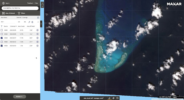
Examples: See Iroquois Reef--this place is under contention because of Chinese ships landing on/near the reef. So, how can we monitor it? One answer: Use DigitalGlobe (Maxar product) to select the image and time that matches your need:
 |
| Iroquois Reef (P/C DigitalGlobe) |
No fishing boats in sight on this Feb 27, 2022 image. But if you look around in the Spratley Islands, fishing vessels aren't hard to find. Here I used Google Earth to spot 7 fairly large ships anchored just west of Jones Reef (click on the image to see it enlarged):
 |
| Jones Reef with ships in view (P/C Google Earth) |
 |
| Brisbane Oct 27, 2021 (P/C DigitalGlobe) |
 |
| Brisbane Mar 6, 2022 (P/C DigitalGlobe) |
 |
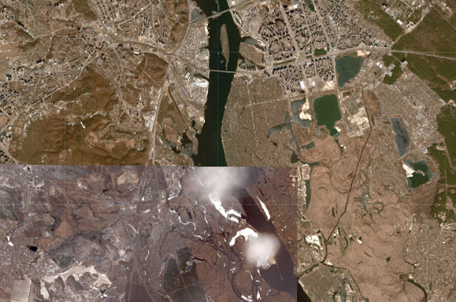
| Kiev as of Feb 26, 2022 (P/C Sentinelhub Playground) |
 |
| Pyramids (P/C Google Earth on web browser) |
 |
| Pyramids (P/C Bing Maps) |
 |
| Pyramids (P/C Mapbox) |
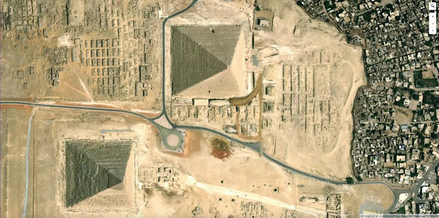
If you look carefully, you can see differences in the buildings that are at the edge of the perimeter. These are really taken at different times, although it's hard to get an exact date from these sources. For specific times and dates, use another service, such as SentinelHub. Here's that same location, but with a date-stamp of 2022-03-09:
 |
| Pyramids (P/C SentinelHub's EO Browser) |
SearchResearch Lessons
FOOTNOTE: This post took a few extra days to write solely because there ARE so many options out there: So many things to check out! If you're just trying to do a bit of SRS on the cheap, now you know where to go. But if you're doing this professionally, be sure to look for providers that specialize in your region of interest. There are companies that do specialty services (e.g. business applications such as counting cars in a shopping mall, or doing agricultural crop health assessments), and there are companies that do speciality regions of the world (e.g., images of the coastline of North America, images over Australia, or imagery of South America). Search BEFORE doing a lot of work on your project!


Wow! Dr. Russell!
ReplyDeleteFantastic and very helpful and interesting. I haven't seen the spreadsheet, however, tried Digital Globe on mobile. It's awesome. I searched home. On mobile it's harder to recognize because the green rectangle is not available.
Love the answer and the footnote. Learning what can be done and what is already there to use, it's amazing. I had no idea. Do you think some of those companies (in case someone needed the information and paid, could solve the SRS Challenge about irrigation that you solved years ago in a new, easier way?
Tried your query adding 2022
DeleteAnd found
Top 9 free sources of satellite data [2021 update] some not on Dr. Russell's list. They add Google Earth
https://www.skywatch.com/blog/free-sources-of-satellite-data
And
What does real-time satellite data really look like
https://www.skywatch.com/blog/real-time-satellite-data
if only there was a provider with overheads from the future…
ReplyDeletethought this might be from the future — but not an overhead view, turns out it is from the past and is too upbeat…
interesting as video:
bird flying ~ 15 sec in
Vantage
floods & fires
ReplyDeletepart of North Danger Reef
other pyramids… of sorts
ReplyDeletescattered
SoCal
overhead - different from Egypt
IL
the green Monk
Cahokia