While running...
... in a nearby open space preserve on the San Francisco peninsula the other day, I came across a somewhat mysterious sign.
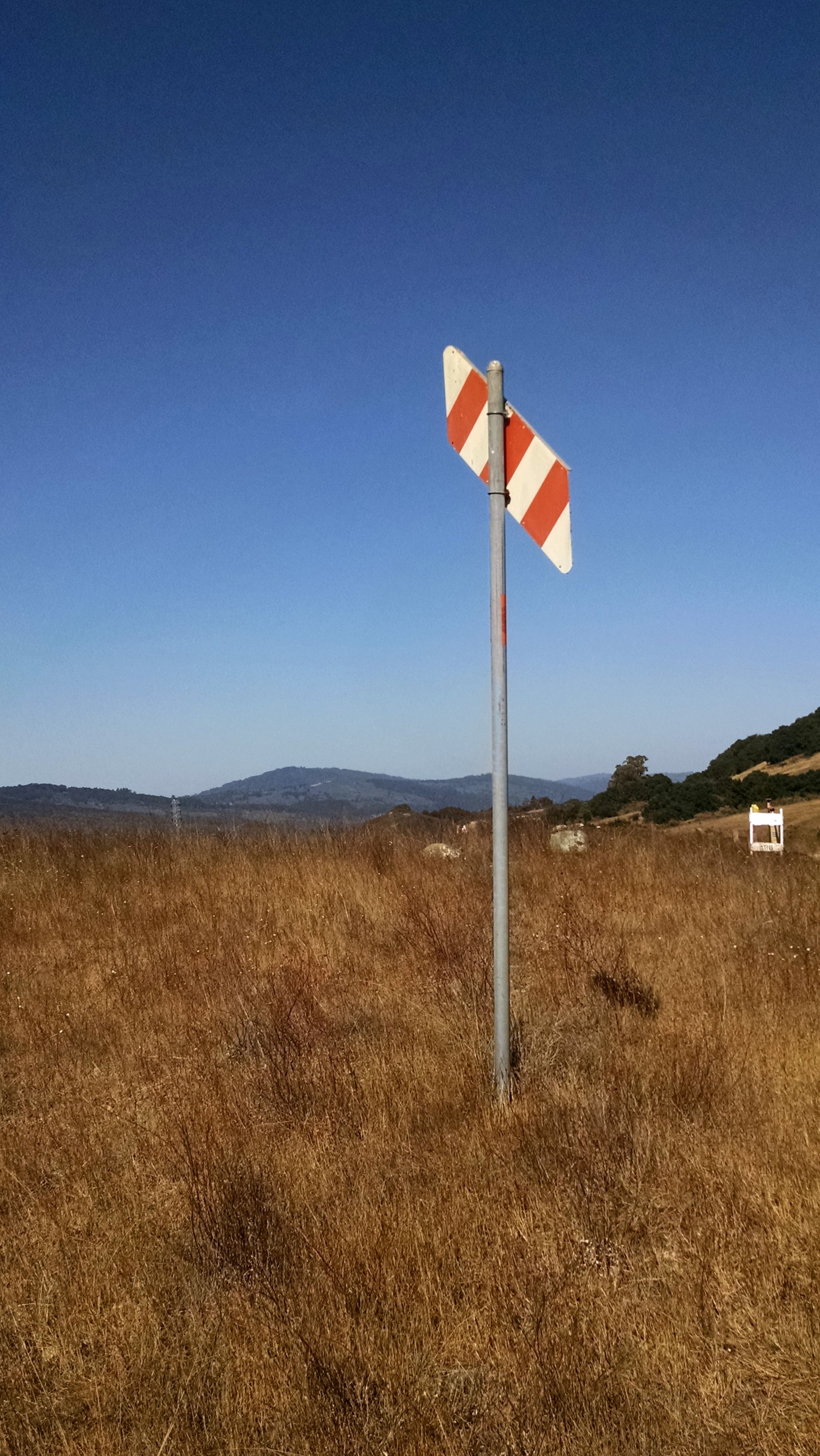
I figured this must mark something pretty impressive, because it's just out in the middle of a field near a nice trail.
Even more strangely, when I turned around and looked south east from this marker, I saw the following hillside:
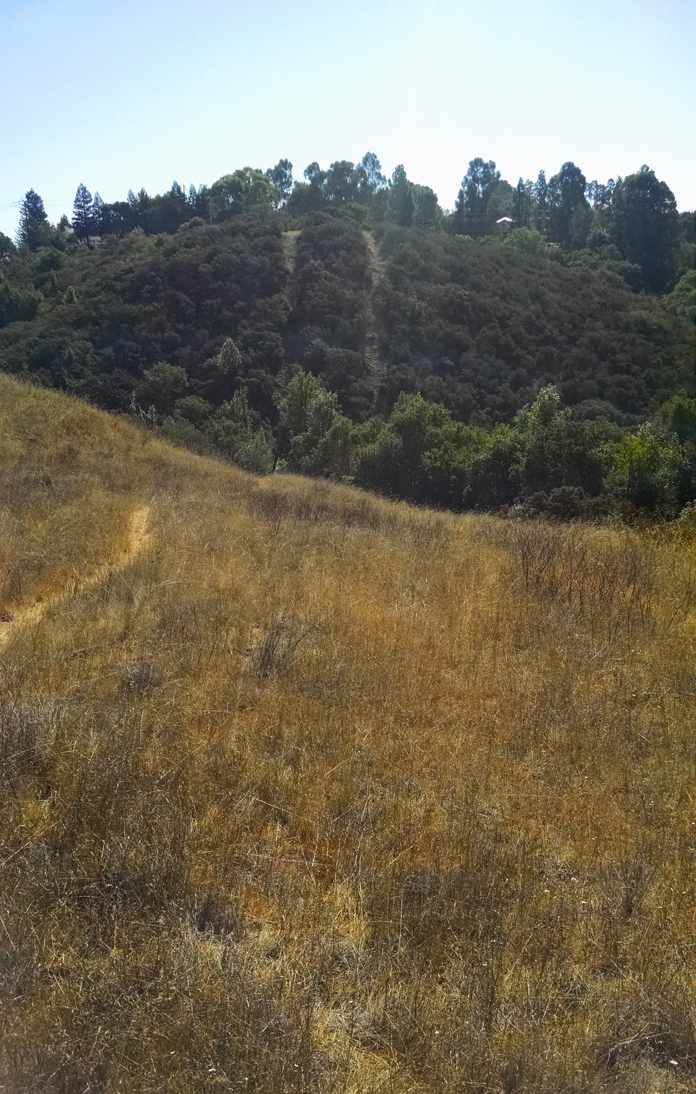
You can see the trail, and then on the hillside across the little valley, I can see two parallel tracks. They look like trails, but when I went over there, I found a fence blocking my path with a "no trespassing" sign. Huh.
Naturally, I'm curious. Can you help me figure out what's going on here?
This week's Challenge is about starting with one piece of information and then working from that to another, and another, and another.
1. What does this sign indicate? Why would someone post this in the middle of an empty field?
2. What's up with the two trails to the south? Why are they there?
3. Can you figure out why that small caution sign is there in the middle right of the first picture above?
Any ideas? I found this to be pretty interesting, in part because I had no idea what these kinds of signs are all about, and it opened up a whole new whole of things I'd never thought about before.
Hope you find this Challenge equally engaging.
When you figure it out, be sure to tell us HOW you found out!
Search on!
— this may have something to do with it, but now I'm covered with poison oak and may have seen a rattlesnake (but no smart pig) - too shakey & itchy to type more…
ReplyDeleteused Jeffery's Exif viewer to get started…
beware the open flame or spark…
edgewood
related backstory
smart pig
friends of edgewood, line 109, Hydrostatic Pressure Testing, sniff hole @ intersection of the Clarkia and Sunset Trails
march bill inserts - similar sign
gtl - edgewood park
hydrostatic testing
park/trail summary
map
part of the impetus
aftermath analysis
record-setting $1.6 billion
the story of edgewood…serpentine grass & chaparral
and - from 2004
flora sampling
why?
open space is disappearing - squeezing the 'plex…
sunnyvale ⌘
Good day, Dr. Russell, fellow SearchResearchers
ReplyDeleteSearched:
[sign 3 red stripes road] in Google Images. There found an image
with name that searched [red white hazard stripes]
Barricade tape, Wikipedia Site mentions the meaning.
[red white hazard stripes california]
PROCEDURES FOR THE IDENTIFICATION AND MANAGEMENT OF LIFE HAZARD ZONES Document says: Remember the slogan: THREE STRIPES, YOU’RE OUT! and it is: The Standard for Identification of a LIFE HAZARD ZONE
[red and white hazard signs]
[red-white-hazard-stripes OSHA]
Checked Exif data for coordinates:[37.461667, -122.282333 ] Clarkia Trail. In Google Maps visited site an saw image with Green/White sign: Safety and First Aid. Also noticed that in the little image in Google result map, there is a pink mark but when I clicked to view in Google Maps that mark disappears. What could that be?
[clarkia trail california] in News: The fire is located 12 miles east of Clarkia in Glover Creek/Woesner Ridge and into west Floodwater.
["clarkia trail" california]
Answers
1. What does this sign indicate? Why would someone post this in the middle of an empty field?
A: Red / white for Fire Prevention and Protection Equipment.
Be back with more.
Is 37°27'41.8"N 122°16'56.4"W [provided with geolocation]
ReplyDeleteBelow West Rocky Way, Woodside CA ( Used Google Earth >Streetview not close to sign) From Google Earth following the double trail the only thing I see before the housing development is power lines running across the top and a power substation further along the top which runs alongside Cañada Road. So I think it's indicating power lines. (not verified).
http://www.friendsofedgewood.org/wp/wp-content/uploads/PGE-Gas-Pipeline-Position-Paper-v2.pdf
2 Looking close in Google Earth mid way up in the trees these trails looks like they have pipes/cables exposed.
3 At this point I am guessing its for kite flyers or small model airplanes warning them of the power lines.
…since we had extra time… ("then working from that to another, and another, and another.")… looks like an intriguing trip… where's the line between investigation & conspiracy? keep an eye out for frequencies & Kenneth…
ReplyDeleteis that a rhombic hexecontahedron update?
a bit of incognito & a touch of stealth
Margot Williams
“2430 E St. NW”
interesting
there's a chill
top 10
Stegastein
risikoatferd
…and just to tie it to today's/yesterday's challenge:
Britpipe in the old days
[Edgewood park and nature preserve]
ReplyDelete[Edgewood park and nature preserve electric fence] In your second photo saw the electric fence and searched with that.
EDGEWOOD PRESERVE
ROUTING ANALYSIS
[pacific gas and electric company intext:"clarkia trail"]
Map with Pipelines
Edgewood Explorer
Gas Pipeline runs near.
ReplyDeleteJeffrey's XIF viewer using cropped image shows us exactly where you are. Now, I still don't know why that sign is there nor what the double pathway is.
I think it is warning sign of the junction on Clarkia @ Sunset. Confirmed by Strava where you noted Clarkia at Sunset Trail Intersection. We note that horses are welcome on nearly all the trails.
Now for the double lines. Not power lines which I can follow from the sub station. What then ?
http://www.friendsofedgewood.org/pge-pipeline-project Shows that the double lines are where the PG&E gas pipeline is located with its access road beside it. Nice maps and explanations.
Cheers
jon tU
good luck…
ReplyDeleteTh
Fr
Started with search-by-image on original image -- nothing interesting.
ReplyDeleteTried cropping to just the orange-white sign -- all results were flags, probably because of blue sky background.
Pulled the lat/lon from the image with exiftool, look in google maps -- nothing obvious
USGS topographic maps often have interesting features marked, so examine that lat/lon with the National Map Viewer, turn on all the overlays -- nothing obvious.
Recalled vague memory that these are pipeline indicators, so search [orange white pipeline warning sign] -- nothing obvious in the first 8 pages, but the iamges are all over the place, so lets try localizing
PG&E are the local gas pipeline people, so try [orange white pipeline warning sign pge] -- that's it, in the second image.
So, let's try that in a web search instead of images -- in the second hit, news.stanford.edu/news/2010/september/gas-pipeline-story-092110.html we see "One is a diagonal sign about eight feet above the ground with orange and white ... gas pipeline, clearly marked with a warning of Gas Pipeline below"
OK, is there really a gas pipeline at that location? Search [gas pipeline national maps] -- we find the National Pipeline Mapping System at https://www.npms.phmsa.dot.gov where we can "choose public map viewer", "choose state", "choose county", then Zoom To (magnifier over green splot) select location by lat/lon, in DMS: 37 27 41.83 N, 122 16 56.41 W -- yes, there's a pipeline (or two or three) there.
"In accordance with PHMSA’s security policy, the scale in which the user may zoom into NPMS data is restricted. The user may zoom into the NPMS data at the map scale of 1:24,000."
So... it's a pipeline warning, the two trails are likely where two different pipelines run, not clear why there's another caution sign but perhaps there has been some work in the area.
Nicely done. Thanks, Nick!
Delete— one piece of info leading to another and so on… and a grand old tree's demise…
ReplyDelete⎈ recent leak in Richmond district of SF (NOT the same signage you saw)
⎈ San Bruno related tale - hard on the flora - Quercus agrifolia included
⎈ Sudden Oak Death
⎈ the Tree Hunter
⎈ The Great Pontfadog Oak in Wales
SEARCH: boundary marker signs
ReplyDeleteRESULT: nothing
SEARCH: field sign "orange and white"
RESULT: nothing
SEARCH: signage "orange and white" AROUND(10) stripped
HIT: https://answers.yahoo.com/question/index?qid=20090401092240AATgPnT
RESULT: Orange and white, usually on an orange post is an underground natural gas line
ACTION: Download photo put into Photos app
RESULT: EXIF reveals taken with Motorola XT1058 @Edgewood Park & Natural Preserve, Woodside, United States
ACTION: Open Google Earth
ACTION: Input 37.46162, -122.2823366666667
ACTION: Scan for conspicuous parallel trails
RESULT: Likely twin pipelines
VISIT: http://parks.smcgov.org/edgewood-park-natural-preserve
SEARCH: site:parks.smcgov.org "edgewood" construction October
HIT: http://parks.smcgov.org/sites/parks.smcgov.org/files/events/100313%20parks%20minutes.pdf
DOC SCAN: Noticed "PG&E 109 pipeline replacement meetings"
DOC SEARCH: "edgewood"
HIT: "Mr. Bill Korbholz, Friends of Edgewood Park and Natural Preserve, expressed concern and opposition to the proposed configuration of the replacement PG&E 109 line in Edgewood Park."
ASSESSMENT: The sign is there as part of pre-construction or in relation to potential retrofitting.
TIME SPENT: About 30 minutes, 10 of it messing around and refining search methods.
FURTHER RESEARCH: Would search for "Bill Korbholz" "edgewood" and continue from there.
since you have been abroad much has occurred in San Mateo county, Redwood City —
ReplyDelete… checked the location again and all seems to be proceeding swimmingly — landscape/trail features&enhancements are in place,
along with the advertising, flare pipe stands and E-Z Access above ground pipeline, with robotic/AI monitoring (25/7.4/362) & next level, info signage - all is good in Edgewood…
be advised - the Clarkia Trail has been upgraded to an eXtreme running/sprinting/jog-4-ur-life trail with a 5♦ rating…
PG&E pipeline#109 construction update
… looks like a very interesting crowd - did you learn anything new?
ReplyDeletetranslations
"@henkvaness @researchclinic @MargotWilliams @leoreitano @RosariaTalarico If these people can't find it, then it doesn't exist!"
61.117287, 10.476933
RebelMouse
Paul Myers UK/BBC
research clinic
history
(from Wikipedia)"Early international collaborations on the ARPANET were rare. European developers were concerned with developing the X.25 networks. Notable exceptions were the Norwegian Seismic Array (NORSAR) in June 1973, followed in 1973 by Sweden with satellite links to the Tanum Earth Station and Peter T. Kirstein's research group in the United Kingdom, initially at theInstitute of Computer Science, University of London and later at University College London.
In December 1974, RFC 675 – Specification of Internet Transmission Control Program, by Vinton Cerf, Yogen Dalal, and Carl Sunshine, used the term internet as a shorthand forinternetworking and later RFCs repeat this use. Access to the ARPANET was expanded in 1981 when the National Science Foundation (NSF) funded the Computer Science Network(CSNET). In 1982, the Internet Protocol Suite (TCP/IP) was standardized, which permitted worldwide proliferation of interconnected networks."