Wednesday, March 30, 2022

SearchResearch Challenge (3/30/22): Where is the oldest solar observatory in the Americas?

We all watch the sun... 


... sometimes with sunscreen, but nearly always at sunrise and sunset.  We notice when the days grow shorter or longer, and as we've seen in earlier SRS Challenges, it's an endless source of fascination for people, shadows, and the time of year.  

Since we've talked about the patterns that the sun makes in the sky, it got me to wondering, when did people first start keeping track and building observatories?  We know that Stonehenge, those marvelous circles of stone and ridges of earth in England, was built between 3000 and 1520 BCE.

What about the New World?  When did similar things start here? 

That's today's Challenge--can you find out? 

1.  When was the first observatory for sun-watching purposes created in the Americas?  Can you find out who made it?  Where is it?  And what happened to those people?  

This Challenge isn't hard, but when I found the answers, I was a bit surprised.  And naturally, once I started learning about these things, this led to further questions as I followed my curiosity a bit.  

I'm curious now: What else did you find interesting to seek out?  What did this Challenge prompt you to go learn about?  

Curious is as curious does.  Where does all this take you?  

Tell us your stories in the comments below. 

Happy observing! 

Search on! 

Wednesday, March 23, 2022

Answer: Finding the connections?

 How is this like that? 

.

Seems to me that noticing how ideas, people, places, and words all link together is a fundamental to creative thought.  

Last week's Challenge was an example of this kind of connective thinking, one that I hope leads you to learning how to find your own fascinating connections.   

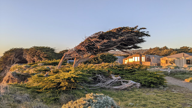
Backstory:  I was walking along a trail that follows the edge of an oceanside bluff in a place that has wind and weather that always comes from the same direction.  In this case, the winds always come out of the west, flows over the bluff, and then blows constantly on the trees and shrubs at the top of the cliff.  As you'd expect, this causes some pretty serious deformations in the way the trees grow.  The tree shown above was especially bent and pruned by the wind, as are most of the trees along this part of the coastline.  

That walk led to today's Search Challenge: 

1. If I want to learn more about such bent and deformed trees, what's the specialized search term that I'd want to use?  (Hint: There is a very specific term to describe such trees--that's what you seek.)  

Where do you start with such a Challenge?  In my case, I suspected that there would be a specialized term about such trees--and as we know, if you have a precise term for something you'd like to find, it makes your search (and your corresponding learning) that much simpler.   

My first search was: 

     [ tree bent over by wind ] 

and after scrubbing through the results (and NOT finding anything useful--just lots of information about how to straighten up bent trees), I tried a more direct route: 

     [ word for tree bent over by wind ] 

and--lo and behold--the first result was exactly what I was looking for.  


Of course, once I learned this, I did a few followup queries to make sure that I understood what krummholz really meant.  As the Wikipedia excerpt suggests, it has a connotation of being a tree at a subarctic or subalpine place.  But as I looked around, it's clear that the term is used more broadly to include all kinds of trees that are bent over, pruned, edited, or otherwise shape-shifted by wind and weather.  

2. What is the name of a musical instrument that sounds a lot like this specialized term?  (Hint: The word for the instrument shares a language of origin and the first 6 letters with the tree-term.  This is one of those "you'll know it when you see it" kinds of Challenges.)  

Now that we know the term krummholz, I did this : 

     [ krummholz musical instrument ] 


I'm not quite sure what I expected, but the spelling suggestion of "krummhorn" is great!  

When you look up krummhorn, it's quickly clear what the connection is: 


A krummhorn (also spelled crumhorn) is a bent wooden instrument.  "Krumm" is the German term for "bent," so it is literally a "bent horn."  Interestingly, from the Wikipedia entry we also learn that this term is still a part of English as heard in the term "crumpet" (a curved cake) and "crumpled" meaning a bent piece of material, as in "he crumpled the piece of paper..."  

"So", my wondering mind thinks, "is the crumhorn made from a bent piece of wood?  If so, how would they drill a curving hole?"  

A quick query solves that question:  

     [ how to make a krummhorn ] 

which leads to a fantastic video of the production of a krummhorn.  Answer:  The wood is initially a straight cylinder, which is drilled through, and then steamed and bent into the final curved shape.  It's worth watching this video to see how the krummhorn comes to be: 


What's remarkable is how quickly the tube is bent from straight to curved--just a few seconds!  

Regular Reader Mathlady had a slightly different approach to the Challenge--her query was [ krummh musical instrument ] which gave her this result: 


Notice that in this case the Google spelling corrector kicked in on the partial word "krummh"--when Google asks (in the red text above) "Did you mean:" that's a spelling correction.  Fortunately, the word krumm is a legitimate German word (meaning "bent"), and all of the results feature "krumm" (as in "krumm horn") the instrument we seek!  

My last query was to YouTube for krummhorn, which led me to this wonderful video showing what a krummhorn is, how it works, and how it sounds in a trio consort of krummhorns.  Worth a watch: 


SearchResearch Lessons 


1.  Pay attention to suggestions and spelling corrections!  When searching, as in horseshoes and hand grenades, close is often good enough.  If you watch the Google spelling corrections and the suggested searches, you can often recognize a better version of what you're searching for--keep a weather eye open to the nearby alternatives!  

2. Once you have an answer, play around a bit and learn some of the surrounding context.  We could have framed this Challenge as simply "what's the bendy tree called?" but then we wouldn't have noticed the connection to these wonderful Medieval instruments (or learned the German word for "curved").  There's no end of fascinating things to learn, and interest-driven learning is the best.  

Stay curious, my friends!  

Search on! 


Wednesday, March 16, 2022

SearchResearch Challenge (3/16/22): Finding the connections?

 Finding connections... 

.

.. is a good part of what I do in my day-to-day work.  As a professional researcher, I often look at data and try to figure out what this data is telling me, and how it connects to other things I know about. In particular, I try to understand how X connects (or influences) Y.  That's sort of science in a nutshell--how do things connect?  

Here's an example of this kind of connective thinking that occurred to me the other day.  

I was walking along a trail that follows the edge of an oceanside bluff in a place that has wind and weather that always comes from the same direction.  In this case, the winds always come out of the west, flows over the bluff, and then blows constantly on the trees and shrubs at the top of the cliff.  As you'd expect, this causes some pretty serious deformations in the way the trees grow.  The tree shown above was especially bent and pruned by the wind, as are most of the trees along this part of the coastline.  

As you can see, it leans away from the wind and rain coming off the bluff (which you can barely see falling away into the sea on the far left).   

While walking past this tree, I wondered today's Search Challenge: 

1. If I want to learn more about such bent and deformed trees, what's the specialized search term that I'd want to use?  (Hint: There is a very specific term to describe such trees--that's what you seek.)  

And, as I was thinking about that term, I realized that it made a connection to a musical instrument, also made of wood, that uses the same bit of language in its name.  The moment I realized this, I understood the connection!  This leads to the connecting Challenge: 

2. What is the name of a musical instrument that sounds a lot like this specialized term?  (Hint: The word for the instrument shares a language of origin and the first 6 letters with the tree-term.  This is one of those "you'll know it when you see it" kinds of Challenges.)  

I don't think this is too hard, but it's fun to find connections between very different parts of one's life (in my case, a connection between botany and music).  

Let us know how you did.  Next week I'll talk about what I did to figure out this connection.  

Search on!  


Friday, March 11, 2022

Answer: What are some good (almost) real-time satellite image sources?

  Seeing the Earth from space... 


... is a truly remarkable ability. It literally changes your perspective.  What's even better, in these days of ever-cheaper costs to fly a satellite, and the increasing capabilities of small satellites, space images are becoming easier (and cheaper) to get. 

The Challenge for last week was to find good aerial or satellite images that are more-or-less in realtime.  As you can appreciate, the big problem is getting your hands on current images--or at least accurately time-stamped images from the not-too-distant past.  Getting near-real-time imagery would be great, but often that's outside the budget of many non-professional searchers. 

So today's Challenge is a kind of collective ask for all people who do SearchResearch: 

1. What are the best resources to get time-stamped satellite images?  How can an ordinary SearchResearcher get their hands on satellite images not very long after (or even during!) a major event?  

When faced with a problem like this, I usually start with my "list of" trick, beginnings with a search like this: 

     [ list of satellite image providers ] 

and sure enough, this gives a set of web pages that have long lists of potential sources (even including 4 ads at the top of the SERP pointing to commercial sources).  One of the more useful results here is "15 Free Providers" with links to several satellite image services.  (And, to tell the truth, I was expecting to find something like this on the results page.)  

Naturally, if you've got a bunch of sources like this, my natural inclination is to organize them on a Google Spreadsheet.  Not only does the sheet put everything I find into a single location, but as I read through the results, I'll find different properties of the image providers that I might want to sort or filter.  

Here's that spreadsheet.  Enjoy it. (And let me know if you find any errors.)  

I started just by collecting the links to many different providers.  Then, for each one, I explored a bit about what they offered, what they're good at, and the considerations to keep in mind.  

I found that the tradeoffs are always the same: cost (you can get nearly anything if you want to pay), resolution, and timestamps.  

That is, it's easy to get free low-res images without a particular time-stamp (such as by using Google Maps, Bing Maps, or Google Earth).  But if you're looking for images from one specific date (especially if it's recent), then you'll need to use one of the providers that gives you fine-grain control of your imagery.   

Examples: See Iroquois Reef--this place is under contention because of Chinese ships landing on/near the reef.  So, how can we monitor it?  One answer: Use DigitalGlobe (Maxar product) to select the image and time that matches your need: 

Iroquois Reef (P/C DigitalGlobe)

No fishing boats in sight on this Feb 27, 2022 image.  But if you look around in the Spratley Islands, fishing vessels aren't hard to find.  Here I used Google Earth to spot 7 fairly large ships anchored just west of Jones Reef (click on the image to see it enlarged):  

Jones Reef with ships in view (P/C Google Earth)

The big difference here is that while the Google Earth is a great satellite image, the only time/date information is that this image comes from Maxar, 2022.  (Google Earth aggregates many sources of satellite imagery, including Maxar.)  But if you go to DigitalGlobe, you can get the specific date of the image.    

Here is another pair of images of the Oxley area of Brisbane, Australia.  You can see the extent of flooding in the brown patches (previously green areas flooded by brown, silty water).  Both of these images are also from Maxar's DigitalGlobe.  

Brisbane Oct 27, 2021 (P/C DigitalGlobe)

Brisbane Mar 6, 2022 (P/C DigitalGlobe)


Another useful provider is the SentinelHub's Playground website.  You can quickly scrub through different parts of the world and select images by date.  Below is an image from Kiev taken on Feb 26, 2022.  (If you do this and look at the images from nearby dates, you'll quickly find out how many days Kiev is covered in clouds! It's hard to get a clear view.)  This is at 10m resolution, not great for seeing much detail, but at least we know what date this image was created.  

Kiev as of Feb 26, 2022 (P/C Sentinelhub Playground) 


However, sometimes you can find public images that are shared as part of a special series or collections.  Example: Soar has a wonderful collection of images, including this great high-res image of downtown Kiev as of Feb 28, 2022 Note that this isn't part of their usual image set (which is at much lower res), but a special collection.

St. Sophia Square, Kiev, Ukraine (Feb 28, 2022--30 cm resolution). P/C Soar.


You can see the differences in the images and resolution by comparing several different sources of the same (well-known) location.  Here are the pyramids as seen by different providers.  

Pyramids (P/C Google Earth on web browser)

Pyramids (P/C Bing Maps) 


Pyramids (P/C Mapbox)

If you look carefully, you can see differences in the buildings that are at the edge of the perimeter.  These are really taken at different times, although it's hard to get an exact date from these sources.  For specific times and dates, use another service, such as SentinelHub.  Here's that same location, but with a date-stamp of 2022-03-09: 

Pyramids (P/C SentinelHub's EO Browser)


Note that images are usually composed of multiple tiles, each of which might have been taken at a different time.  Here's an example where you can see the tile edges of a location near Kiev.  This is fairly typical as not every satellite pass over a given location will get all of the region in a single shot:  

Satellite photo showing tiling


SearchResearch Lessons 


There are many different mapping products with widely varying capabilities.  It's complicated by the fact that single companies sometimes offer multiple products, using some combination of their own images, their own analytics, and data from multiple other satellites giving multiple kinds of images (different analyses and different sensing bands).  

If you're a researcher, this an exciting time--so much opportunity!  

There are lots of companies creating new products, merging data sets, making new kinds of analytics with speed and frequency.  

I haven't even begun to cover the many aerial image companies that are also combining data to get areas with incredibly high resolution (for instance, NearSpaceLabs are flying balloons to get 10 cm data at reasonable cost.  (Probably not over restricted airspace, though, so don't expect anything from Kiev.)  

Bottom line: For reasonably high-res images WITH fairly recent time stamps, try SentinelHub's PlayGround or EO Browser.  Another solution would be Maxar's DigitalGlobe.  For higher-resolution, you can use other services, but be aware that you might have to spend some money to get those images--or hope that one of the providers image collections happens to also have what you seek.  

And, as always, stay tuned because this space is changing very quickly.  

Search on!  


FOOTNOTE:  This post took a few extra days to write solely because there ARE so many options out there: So many things to check out!  If you're just trying to do a bit of SRS on the cheap, now you know where to go.  But if you're doing this professionally, be sure to look for providers that specialize in your region of interest.  There are companies that do specialty services (e.g. business applications such as counting cars in a shopping mall, or doing agricultural crop health assessments), and there are companies that do speciality regions of the world (e.g., images of the coastline of North America, images over Australia, or imagery of South America). Search BEFORE doing a lot of work on your project! 

Wednesday, March 2, 2022

SearchResearch Challenge (3/2/22): What are some good (almost) real-time satellite image sources?

 We live in a complicated time... 


... with all kinds of conflicts, disasters, and changes in the landscape of our world. There's a conflict in Ukraine, recent fires in Colorado, massive flooding in eastern Australia, and conflicts over fishing and islands in the South China Sea.   

As we've seen many times before, having good aerial or satellite images can be key to understanding what's really going on.  Do the news stories align with ground truth?  How can you know?  

And yet, a huge problem is getting your hands on current images--or at least accurately time-stamped images from the not-too-distant past in order to make sense of what's going on.  Getting real-time imagery would be great, but often that's outside the budget of many non-professional searchers. 

So today's Challenge is a kind of collective ask for all people who do SearchResearch: 

1. What are the best resources to get time-stamped satellite images?  How can an ordinary SearchResearcher get their hands on satellite images not very long after (or even during!) a major event?  

And, when you give us your answer, be sure to include any little times you have about using your favorite up-to-date image source.  (I've found that sometimes they can be finicky to use. Most often, the problem is in selecting the details of the kind of image you want: want cloud cover (or not)?  want multi-spectral images (if so which ones)?  what resolution would you prefer?  etc.  Give us your pro tips on using these sources!  

I'll collect all of the comments and include my favorite resources.  (For instance, as much as I love Google Earth and Google Maps, they're not the best places to go for current satellite images.) 

And, if you have the time, let us all know HOW you found your resources.  

All of our collected wisdom next week.  

Search on!