Even more details...
Often, as we do research (especially of the SearchResearch kind), the little details of the Challenge turn out to be important. This is especially the case when you're trying to figure out where a particular picture has been taken.
Learning to "read the details" of a photograph is a key skill for photoanalysis, and that's what the point of this week's Challenge is. Can you figure out where these locations are?
Here's what I did to figure out these 3 locations.

Okay, so THIS one is embarrassing.
If you right-click on this, you can "Reverse Image Search" and find that I've already used this picture in an earlier SRS post! If you read the SRS post "What am I doing?" from August 22, 2012 you'll find that this is the scene across the street from the Van Gogh Museum in downtown Amsterdam!
Ooops.
The method I talked about then was to look at the scene for clues. That's what I was hoping you would do this time. So... ignoring the early post, THIS is what I would do today.
There's an obvious sign on the street that suggests it's near a Hard Rock Cafe near the Leidesplein. (You just have to zoom in a bit on the image.) If you search in Google Maps for Leidesplein, you'll end up in central Amsterdam. If you then search for [Hard Rock Cafe] you'll find the exact location of that rock-and-roll themed restaurant in Amsterdam.
This is the map I see:

The next step would be to search the map for clue. Back when I originally posted this image, you could search for the Randstad offices near there. (See the blue sign for "Randstad" on the right of the image.)
Back in 2012, there were two Randstad offices. One of them matched the office shown in the picture, located in a brick building.
But this is no longer true! NOW what?
Look at the picture. What else can you see?
There's a sign for the "Holland Casino." A quick search on Maps shows us that's near the Hard Rock Cafe, so that doesn't really help.
Almost everything else is covered by trucks, cars, and people.
To solve this SearchResearch Challenge now--in April 2017--you have to do something a bit more clever. (Let's ignore the answer from 2012 for a moment.)
If you look between the yellow truck and the orange container, you can make out part of a sign. It's "stef?s" (where the ? means a character or two that I don't know because it's blocked by the lightpole).
As you know, Google doesn't do partial-word matching.
BUT... that doesn't stop us from using autocomplete in Maps as a kind of partial-word matching tool!
Look at this. Here, starting with the map centered on the Hard Rock Cafe (Amsterdam), I started typing the letters I can see in the image:

What I'm getting (as I type) are all of the business names in the area that start with my query fragment. At this point, it's just "stef"--but as you see, there are a few places that begin like that. These are all possible place (or business) names in the area.
When I click on each hit (such as "Stef's Bakery" in the #1 position), I can quickly rule out the possibilities. Stef's Bakery, for instance, is in a tiny street, nothing like the picture.
I clicked on a bunch and found nothing.
So I went to the next possibility: "stefa" ... like this:
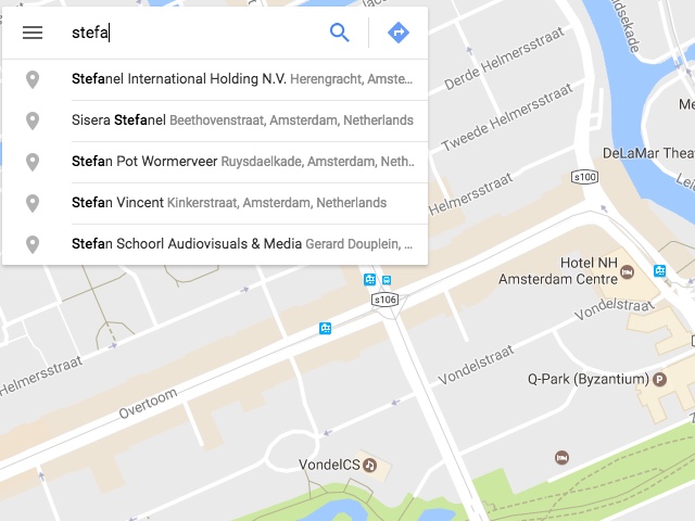
I check each of those.... and.... nothing.
Next one: "stefe"(changing the "a" at the end to an "e"... I'm just working my way through the vowels. I strongly suspect that the next letter after the "f" in "stef" is a vowel.
Look what we have now with the "stefe" partial word search:

And when I click on the first hit here ("Stefels Makelaardij B.V.") I see something really interesting... notice the brick building shown in the Streetview preview just above the name of the company. That looks a lot like our picture above!

When I drag and drop the pegman to that red balloon, it takes me to THIS view of the street:

Amazingly, I see the Hard Rock Cafe sign AND the Holland Casino sign just as in the original image.
If you look carefully (just to the left of the scaffolding), you can see more of the sign (something & Stefels). By looking at the buildings, you can confirm that this is the same place... the picture and the Streetview look very, very similar.
So now, just take a look around using Streetview to try and figure out "what's important about this location."
Once you look behind you, it's clear: This is the location of the Van Gogh Museum in Amsterdam.

And we've learned a new method for finding locations, even when the information is only partial (or out-of-date).
BTW, Google Streetview also has excellent interior Streetview for the Museum. Just zoom in close to the museum, then drag-and-drop pegman into the museum for views like this:


The key to solving this Challenge is to realize that Search-by-Image doesn't work well with the whole image, but cropping the image to the most probably photographed part does work.
What do you think everyone who takes a photo here shoots? Probably the tower.
I cropped my image to just the tower, like this:

If you Search-by-Image for that, you quickly discover that it's the Edmon Low library at Oklahoma State University in Stillwater, OK. (Wikipedia entry for the Edmon Low Library)
What amazes me about this search is that there are thousands of library towers that look pretty much like this one. But there's enough variation among the towers that Search-by-image can tell them apart.

Okay... I played a little trick on you this time.
Of all three of the images in the Challenge, this was the only one that still has its metadata.
Just because the other 2 images were missing the EXIF metadata, you shouldn't assume that this one is missing it as well.
(If you don't know what EXIF metadata is, you can learn about it here at my earlier post about it.)
Uploading this image to Jeffery's Image Metadata Viewer (which recently changed to a new URL: the newly moved Metadata Viewer is here), you can discover that this picture was taken at lat/long 37° 52' 49.2" North, 122° 27' 23.2" West ( 37.880339, -122.456453 )
If you look at the Map for that location, you'll see that I was standing in an open field.

And if you look at the satellite view for that location, you'll see that it's on a hillside, and that there's a chapel (with a cross) directly south of the photo location.

Switching back to Map view, you can see that the very end of Vistazo W St. has a Streeview.
I grabbed that image, and put it side-by-side with the photo to see if they're really the same.

It's clearly the same view (although with different focal lengths on the cameras).
The question was "what's interesting about this particular view?" You can read the answer off the map by zooming out just a bit... Here I've added a couple of sight-lines so you can see the view taken in by the nighttime photo.

If this is correct, then we should be able to see the top of the Golden Gate bridge in the original photo.
Zoom in a bit, and yes, there they are, peaking over the ridge.

It was a beautiful evening, which is why I couldn't resist taking the picture. But SearchResearchers ask questions. And Regular Reader Remmij asked a great question:
Those are all great guesses, but Ramón was able to answer the question by using the EXIF metadata!
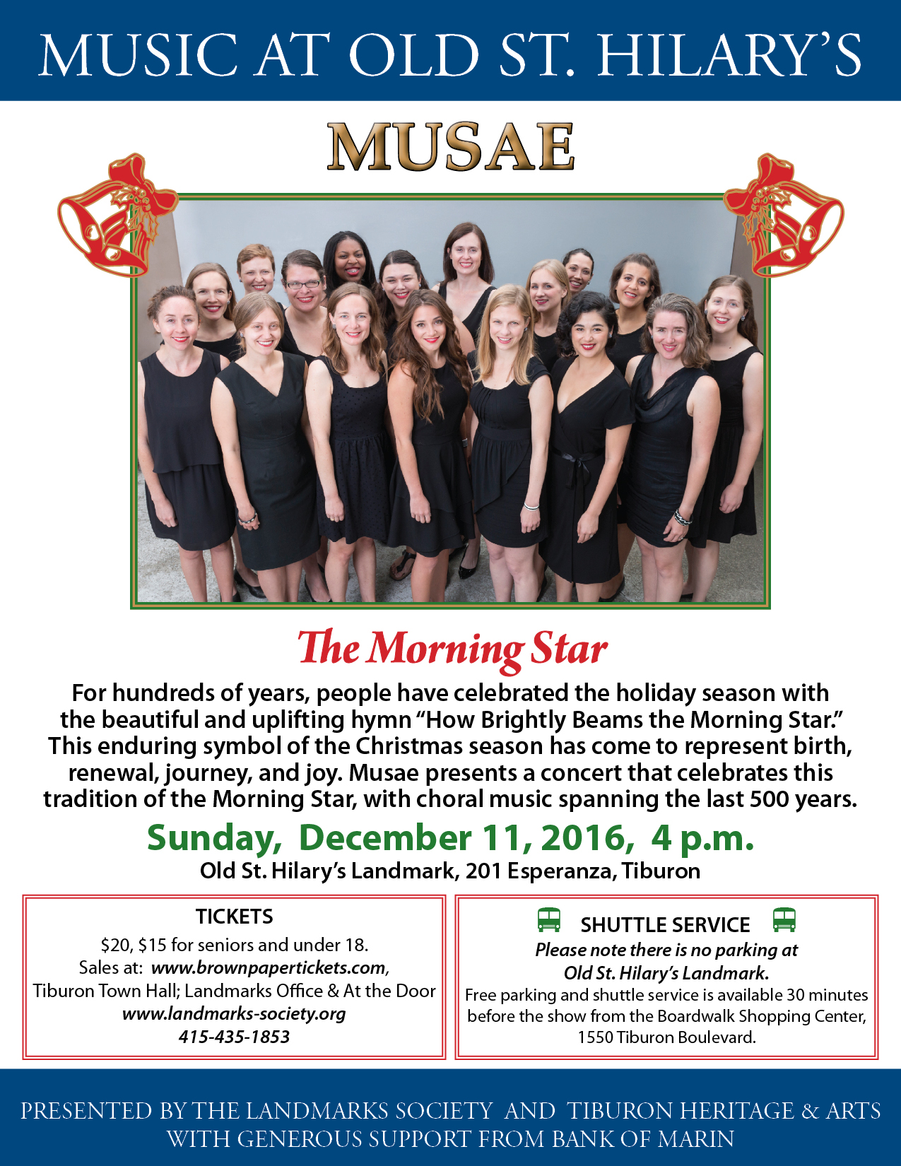
Remember that the EXIF also contains the date and time of the image. It was taken on December 11, 2016 at 5:20PM.
By taking advantage of subject of the photo (the cute little chapel with warmly glowing windows in the lower left), Ramón did a search for:
[Old St. Hilary’s chapel December 2016 events]
and correctly found a concert poster for the a cappella group, Musae. They had a concert at 4PM. The poster also says that there is no on-site parking at St. Hilary's, so I probably parked on Vistazo Street and walked on the trail after the concert.
Which is what I did.
1. Consider the possibility that what you're working with is out-of-date. That was definitely the case with that photo. As we found, it was from 2012, and almost all of the stores had moved away. Luckily, one did not, and we were able to work forward from there.
2. Think about using partial information by checking possible combinations. In the first Challenge, we had some great information (the name of a business, "Randstad") but that WAS out-of-date. We had some location information from the "Hard Rock Cafe" and "Holland Casino," but not enough to pin-point the location. We had to use just PART of a business name. Luckily, by using the Maps auto-completion feature, we were able to try a couple of options (by changing the last letter) and were able to fairly quickly find a combination of letters that led to the exact place.
3. Just because the first 2 don't have EXIF, don't give up! Clues, like images, come from all over the place. Sometimes the data is a little unexpected. You have to keep trying all of the best options first. If they don't work, then go to a more sophisticated method (but don't forget the obvious first).
Hope you had as much fun as I did with this.
Search on!
Often, as we do research (especially of the SearchResearch kind), the little details of the Challenge turn out to be important. This is especially the case when you're trying to figure out where a particular picture has been taken.
Learning to "read the details" of a photograph is a key skill for photoanalysis, and that's what the point of this week's Challenge is. Can you figure out where these locations are?
Here's what I did to figure out these 3 locations.
1. Where is this? (And aside from being a random street, what's important about this location?)

Okay, so THIS one is embarrassing.
If you right-click on this, you can "Reverse Image Search" and find that I've already used this picture in an earlier SRS post! If you read the SRS post "What am I doing?" from August 22, 2012 you'll find that this is the scene across the street from the Van Gogh Museum in downtown Amsterdam!
Ooops.
The method I talked about then was to look at the scene for clues. That's what I was hoping you would do this time. So... ignoring the early post, THIS is what I would do today.
There's an obvious sign on the street that suggests it's near a Hard Rock Cafe near the Leidesplein. (You just have to zoom in a bit on the image.) If you search in Google Maps for Leidesplein, you'll end up in central Amsterdam. If you then search for [Hard Rock Cafe] you'll find the exact location of that rock-and-roll themed restaurant in Amsterdam.
This is the map I see:

The next step would be to search the map for clue. Back when I originally posted this image, you could search for the Randstad offices near there. (See the blue sign for "Randstad" on the right of the image.)
Back in 2012, there were two Randstad offices. One of them matched the office shown in the picture, located in a brick building.
But this is no longer true! NOW what?
Look at the picture. What else can you see?
There's a sign for the "Holland Casino." A quick search on Maps shows us that's near the Hard Rock Cafe, so that doesn't really help.
Almost everything else is covered by trucks, cars, and people.
To solve this SearchResearch Challenge now--in April 2017--you have to do something a bit more clever. (Let's ignore the answer from 2012 for a moment.)
If you look between the yellow truck and the orange container, you can make out part of a sign. It's "stef?s" (where the ? means a character or two that I don't know because it's blocked by the lightpole).
As you know, Google doesn't do partial-word matching.
BUT... that doesn't stop us from using autocomplete in Maps as a kind of partial-word matching tool!
Look at this. Here, starting with the map centered on the Hard Rock Cafe (Amsterdam), I started typing the letters I can see in the image:

What I'm getting (as I type) are all of the business names in the area that start with my query fragment. At this point, it's just "stef"--but as you see, there are a few places that begin like that. These are all possible place (or business) names in the area.
When I click on each hit (such as "Stef's Bakery" in the #1 position), I can quickly rule out the possibilities. Stef's Bakery, for instance, is in a tiny street, nothing like the picture.
I clicked on a bunch and found nothing.
So I went to the next possibility: "stefa" ... like this:

I check each of those.... and.... nothing.
Next one: "stefe"(changing the "a" at the end to an "e"... I'm just working my way through the vowels. I strongly suspect that the next letter after the "f" in "stef" is a vowel.
Look what we have now with the "stefe" partial word search:

And when I click on the first hit here ("Stefels Makelaardij B.V.") I see something really interesting... notice the brick building shown in the Streetview preview just above the name of the company. That looks a lot like our picture above!

When I drag and drop the pegman to that red balloon, it takes me to THIS view of the street:

Amazingly, I see the Hard Rock Cafe sign AND the Holland Casino sign just as in the original image.
If you look carefully (just to the left of the scaffolding), you can see more of the sign (something & Stefels). By looking at the buildings, you can confirm that this is the same place... the picture and the Streetview look very, very similar.
So now, just take a look around using Streetview to try and figure out "what's important about this location."
Once you look behind you, it's clear: This is the location of the Van Gogh Museum in Amsterdam.

And we've learned a new method for finding locations, even when the information is only partial (or out-of-date).
BTW, Google Streetview also has excellent interior Streetview for the Museum. Just zoom in close to the museum, then drag-and-drop pegman into the museum for views like this:

2. Where is THIS? More to the point, what building is this?

The key to solving this Challenge is to realize that Search-by-Image doesn't work well with the whole image, but cropping the image to the most probably photographed part does work.
What do you think everyone who takes a photo here shoots? Probably the tower.
I cropped my image to just the tower, like this:

If you Search-by-Image for that, you quickly discover that it's the Edmon Low library at Oklahoma State University in Stillwater, OK. (Wikipedia entry for the Edmon Low Library)
What amazes me about this search is that there are thousands of library towers that look pretty much like this one. But there's enough variation among the towers that Search-by-image can tell them apart.
3. Finally, where is this... and what's interesting about this particular view?

Okay... I played a little trick on you this time.
Of all three of the images in the Challenge, this was the only one that still has its metadata.
Just because the other 2 images were missing the EXIF metadata, you shouldn't assume that this one is missing it as well.
(If you don't know what EXIF metadata is, you can learn about it here at my earlier post about it.)
Uploading this image to Jeffery's Image Metadata Viewer (which recently changed to a new URL: the newly moved Metadata Viewer is here), you can discover that this picture was taken at lat/long 37° 52' 49.2" North, 122° 27' 23.2" West ( 37.880339, -122.456453 )
If you look at the Map for that location, you'll see that I was standing in an open field.

And if you look at the satellite view for that location, you'll see that it's on a hillside, and that there's a chapel (with a cross) directly south of the photo location.

Switching back to Map view, you can see that the very end of Vistazo W St. has a Streeview.
I grabbed that image, and put it side-by-side with the photo to see if they're really the same.

It's clearly the same view (although with different focal lengths on the cameras).
The question was "what's interesting about this particular view?" You can read the answer off the map by zooming out just a bit... Here I've added a couple of sight-lines so you can see the view taken in by the nighttime photo.

If this is correct, then we should be able to see the top of the Golden Gate bridge in the original photo.
Zoom in a bit, and yes, there they are, peaking over the ridge.

It was a beautiful evening, which is why I couldn't resist taking the picture. But SearchResearchers ask questions. And Regular Reader Remmij asked a great question:
"..… what was Dan doing out there in the dark… trail run? attending a wedding?,a presentation at SFSU? dinner at the Tiburon Tavern? testing the camera on his Nexus for low light capability?"
Those are all great guesses, but Ramón was able to answer the question by using the EXIF metadata!
Remember that the EXIF also contains the date and time of the image. It was taken on December 11, 2016 at 5:20PM.
By taking advantage of subject of the photo (the cute little chapel with warmly glowing windows in the lower left), Ramón did a search for:
[Old St. Hilary’s chapel December 2016 events]
and correctly found a concert poster for the a cappella group, Musae. They had a concert at 4PM. The poster also says that there is no on-site parking at St. Hilary's, so I probably parked on Vistazo Street and walked on the trail after the concert.
Which is what I did.
Search Lessons
1. Consider the possibility that what you're working with is out-of-date. That was definitely the case with that photo. As we found, it was from 2012, and almost all of the stores had moved away. Luckily, one did not, and we were able to work forward from there.
2. Think about using partial information by checking possible combinations. In the first Challenge, we had some great information (the name of a business, "Randstad") but that WAS out-of-date. We had some location information from the "Hard Rock Cafe" and "Holland Casino," but not enough to pin-point the location. We had to use just PART of a business name. Luckily, by using the Maps auto-completion feature, we were able to try a couple of options (by changing the last letter) and were able to fairly quickly find a combination of letters that led to the exact place.
3. Just because the first 2 don't have EXIF, don't give up! Clues, like images, come from all over the place. Sometimes the data is a little unexpected. You have to keep trying all of the best options first. If they don't work, then go to a more sophisticated method (but don't forget the obvious first).
Hope you had as much fun as I did with this.
Search on!
You won't believe this but my first thought when I saw this picture was that it looked like Sausalito looking toward San Francisco, but I didn't have time to look for it.
ReplyDeleteHello Dr. Russell!
ReplyDeleteIn Q2, I think it was luck but Search by Image worked for me without cropping. It said the city and the name of the University.I just needed to select the correct building on similar images and verify.
Q3: I didn't check Exif data due to the reason you mentioned. I found about it only when Remmij mentioned it was in December. I thought the solution involved finding the Chapel without knowing where it is, as Remmij found, finding the missing pieces. As always, lots of amazing lessons and lots of knowledge and fun.
In an out of topic subject. I think Dr. Russell, you will particularly enjoy this link because you like a lot flowers, nature, trees and connections. Hope others find it interesting too. History of Jacarandas in Mexico (in Spanish)
you must be recalling Dan's challenge about the San Diego jacarandas… interesting article, thanks for the point.
Deletehad Google Translate the page to English & noticed a small quirk - it didn't translate the comments… seems odd
one of the comments was even in Japanese…
(like the rhythm of the audio of the Japanese)
no EXIF data here - seems sketchy…;-)
think that is a lava pit near the lower right edge… coming attractions?
I punched your image into Jeffery several times and again just now but it does not show lat lang. I coulda done that one if lat long was there but it never was. Still isn't.
ReplyDeleteWhat am I doing incorrectly ?
jon
Jon, same results for me… using both EXIF viewers I use… Dan must have the 'magic' version.
Delete(maybe platform and/or OS makes a difference?)
Jeffrey's Image Metadata Viewer
others
You are right, Jon! I tried and I don't have EXIF Data. In Remmij extension shows date of the photo. I'll try if exif is shown there.
DeleteYou are right, Remmij we had Jacaranda's SRS Btw, how you did so the San Diego is as a live url but doesn't give options to open in other tab? It only redirects to a new tab with out information. I wonder if Mister Matsumoto worked in San Diego or has a connection.
About lava, yesterday, learned that Indonesia Blue lava is really not the lava the blue one. Very interesting.
sorry – (still missing a couple of my posts here (Otis Redding & Vincent's 164 birthday… sigh)- must be glitchy Tuesday…)
DeleteSan Diego
SD
gremlin - before Kirk
… oh, how 'bout dem Tar Heels?
ReplyDeleteThis comment has been removed by the author.
ReplyDeletesorry – (still missing a couple of my posts here (Otis Redding & Vincent's 164 birthday… sigh)- must be glitchy Tuesday…)
ReplyDeleteSan Diego
SD
gremlin - before Kirk
a form of the Twilight Zone… with gremlin… "Submitted for your approval, a portrait of a frightened man: Mr. Bart Simpson"
Terror at 5 1/2 feet part 1/2 Bart Serling
Terror at 5 1/2 feet part 2/2
Dan, Please explain what is/was going on with your last image. Neither myself, nor remmij, nor Ramon can make Jeffrey divulge the lat/long but somehow you were able to do it. The trick is . . .?
ReplyDeleteCheers, jon puzzled on Vancouver Island
I'm working on it! Turns out that there is a bug (or a new, unannounced behavior) in Blogger that's removing the metadata. I'm trying to understand if this was intentional, or an accident. I'm also looking for a workaround that will let the metadata come through. (FWIW, I would *swear* this worked when I originally posted the Challenge.)
DeleteHello Dr. Russell. Maybe when you changed the first low resolution image with the high resolution, the metadata was removed. Or maybe metadata was just in the low resolution version.
DeleteLooking forward to read what you discover.
Hi again, as you mention it is new because the old SRS Challenges with metadata works perfect Tracking Turkey
DeleteAs you said, Ramón--- the metadata works correctly in that example. So I can't figure out why it's NOT working correctly now. (I have a good guess...)
Deletethe following 3 are re-submits… we'll see – regarding the absence of metadata/EXIF info - privacy move on Blogger/MaGoo's (remember MaBell - whatever happened to her?) part?
ReplyDeletetoo bad Mr. Redding didn't get to do a gig there…
the new chapel
Otis
back story also near Sausalito…
wiki
the Beech
one survivor… Ben S. Cauley, Jr.
Lake Monona
Ben, December 10, 1967
the song, and the bay, lives on… 'Headed for the 'Frisco bay'
sorry – (still missing a couple of my posts here (Otis Redding & Vincent's 164 birthday… sigh, resubmitting 4/05 p.m.)- must be glitchy Tuesday…)
ReplyDeleteSan Diego
SD
gremlin - before Kirk
as Rod might say…
a form of the Twilight Zone… with gremlin… "Submitted for your approval, a portrait of a frightened man: Mr. Bart Simpson"
Terror at 5 1/2 feet part 1/2 Bart Serling
Terror at 5 1/2 feet part 2/2
(FWIW, I would *swear* that I swear during the course of these challenges & attempts to answer in a elastic manner…
and what I post makes sense, until I read it later and it doesn't…while sitting on the dock…)
Dan, are you sure your memory of seeing the metadata isn't from knowing it was there in the original image - I'm assuming you manually stripped the data from the other two images & since you didn't do that with the bay view, you assumed it transferred to the blog post? My recollection of image #3 - before you reposted it - was there was minimal EXIF info then…
FWIW - a comparison of EXIF viewers - tried using one of your older images - from 9/28/2014, Petaluma Temperance Fountain -
ReplyDeleteto see if GPS info was there - and NO - but I did notice that when I just used the Chrome EXIF viewer extension it gave more info, including the date…
when I tried Jeffery's Image Metadata Viewer, there was minimal info, but noticed I could still try the Chrome extension on the image - and now it was missing
the EXIF/metadata it had previously had when it was operating solo… don't know if that helps resolve what is going on with Blogger, but it does seem
to show that different viewers are retrieving different amounts of data - in the past, it seemed that Jeffery's was usually the more comprehensive site…
comparison: Chrome extension on the left - Jeff's on the right w/ the extension showing less data
a side note - ran across this publication and thought it might be of interest to some sRs readers…
ReplyDeleteQuanta
"When I finished my course requirements in graduate school and I started to wonder how I could do research, it turned out that a very famous computer scientist, Jack Edmonds, was visiting the computer science department. I asked him, “How did your greatest results happen? Did they just come to you?” He looked at me, and stared at me, and yelled, “By the sweat of my brow!”"
Jack Edmonds
last try -
ReplyDeleteThursday, March 30, 2017 was Vincent's 164th birthday…
the twitter…
and two of his paintings came back…
#vangoghreturns
bus service
one of the paintings…
“Congregation Leaving the Reformed Church in Nuenen” (1884/85)
"A personal painting, Vincent painted this as a gift for his mother. It shows the church where his father was the minister"
the other painting -
X-Ray - View of the Sea at Scheveningen
a Vinny underpainting/X Ray example from his twitter
X-Ray shows Vinny may have been dreaming of Tiburon/St. Hilary… but then overpainted as a more conventional seascape…
Vincent van Gogh, View of the Sea at Scheveningen, 1882
it was a guy
it starts speaking right away…
Old St. Hilary’s was built as a place of worship for local railroad workers in 1888, 35 years after Vincent was born (March 30, 1853, Zundert, Netherlands)
and two years before he died (July 29, 1890, Auvers-sur-Oise, France).