Can you actually get the time and date from just a shadow? (installment #3)
This is part 3 of the time & date from a shadow Challenge. This is all about using tools, and checking to make sure the tools work the way you think!
-----------
We're back trying to figure out when this satellite photo was taken.
1. What day and time-of-day was this photograph taken?
In our last post, I tried using a lot of photographic resources, but didn't get very far. Turns out that while the Skytree has a LOT of photos, very few are the ones I need!
But I found that by using SunCalc in an interactive mode, I could move the time slider at the top of the page (that's the sun image at the top). You can check it out here. In particular, if you dial in Jan 29, 2020 at 10:42AM, you'll see a modeled shadow that looks just like the photo above!
 |
| Using Suncalc, I can find a time/date that shows the shadow just over the Sumida bridge! I just read the time/date off the panel on the left side. 10:42AM, Jan 29, 2020 |
(And with even more playing around, you'll quickly realize that the shadow is ALSO the same position on Nov 12, at 10:14AM. More on this later.)
But now I'm curious: Is THIS model correct?
I did a search to see if I could find another shadow-casting / modeling online app, and I found a few. The one that appealed to me the most is Shadowmap, which, if you play around with it, can give you a very similar image (note that the underlying base map of Shadowmap doesn't include the Sumida bridge, so I had to guesstimate the position. Luckily, it's pretty close to what SunCalc says...
....although Shadowmap has the time as 11:12AM on Jan 29, 2020.
So... the two models are very, very close...
SunCalc 10:42 AM
Shadowmap 11:12 AM
but 30 minutes difference is annoying. Which one is closer to reality? How can I check?
I know. I can go out and measure a real building, take a photo of a real shadow, and then see what the predictions are!
Early Sunday morning, I went off to a nearby building and took a photo of its shadow at 9:03AM on Oct 17, 2021. Here's what I found--the shadow of the building goes out into the street almost to the center--it's about 1m short of the center.
Here's what Shadowmap predicts as the building shadow for this time (the green triangle shows where I'm standing, looking down the street to the south). As you can see, the Shadowmap shows the shadow going about halfway out into the street.
This is pretty great! The model aligns pretty closely with the real image!
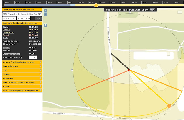
Then I turned to SunCalc and asked the same question, what's the prediction? Here's what SunCalc shows as the shadow prediction for 9:03AM.
But by playing around with the time slider, I found that the shadow hits exactly that spot in the middle of the street at 8:42AM, which is 30 minutes off the Shadowmap prediction. There's that 30 minute difference again!
Let's recap what we know.
First, we know we can find online shadow modeling tools that can help figure out what DATE a particular shadow falls on a given place. By tweaking the dials, we can even figure out exactly what TIME that shadow falls on that place.
In our case, we wanted to know when the Skytree shadow fell just above the Sumida bridge. If we use the Shadowmap tool, we can quickly figure out that it's there at 11:12AM on Jan 29, 2020. By playing around a bit more, we can ALSO find that it fell on that same spot at Nov 12, 2020 at 10:14AM. (You can do the same thing with Suncalc, just add 30 mins.)
That's amazing, but why is it true?
Here's why:
Then, I plotted the curve of the shadow during the day for Nov 12 and Jan 29. As you can see, on both those days, the shadow passes over the middle of the Sumida bridge, just at slightly different times.
If you plot the shadow curves for other days between Nov 12 and Jan 29 (say, Dec 21), those curves will be well to the north of Sumida bridge. After Jan 29, the curves will be well to the south of the bridge.
That makes complete sense to me now. Shadows grow longer during the winter until the winter solstice (Dec 21) and that will put them north of the Sumida bridge. After Dec 21st, they start growing shorter again, until midsummer (at the bottom of the analemma).
The bottom line answer? There are TWO days in the year when that photo could have been taken:
Jan 29 11:12 AM
Nov 12 10:44 AM
Whew! That took a bit of figuring. Thank heavens for online shadow calculators!
But I STILL don't know why the closed form solution (all those math equations) didn't work out. Time to break out a pad of paper, a pencil, and do a little trig.
Stay tuned for the exciting conclusion to our 4 part Search Challenge!
I'll try to push this out on Friday (Oct 22).
Will write up a NEW SRS Challenge tomorrow (Thursday, Oct 21, 2021).
As always, I'm Searching On!


Thanks, Dr. Russell!
ReplyDeleteAfter reading your answer, searched for [analemma online], and found this tool.
https://www.sunearthtools.com/dp/tools/pos_sun.php
Did you tried this one? I tried. However, I can't use the search option to change coordinates