A blog about search, search skills, teaching search, learning how to search, learning how to use Google effectively, learning how to do research. It also covers a good deal of sensemaking and information foraging.
Is it fake? ... is a question that comes up fairly frequently when you're reading online content. We see news stories, social media posts, or images that flash by and make us wonder "Can that possibly be real?" This week's Challenge is to explore a couple of ways to check if something is real or not. This came up for me this past week when a friend posted the following image on his/her Facebook page and wondered how CalTrans was going to get all of that mud and debris off of I-5.
I'm originally from LA, and there HAVE been recent mud slides in the LA area on Interstate 5 (I-5) at a place called the Grapevine (so-called because it's a very twisty freeway through a narrow mountain pass). I've driven that section of road a lot in my life, and this just doesn't look like the Grapevine. So I wondered--is this photo real? This is what started me thinking: What methods CAN we use to tell if something is true and correct? What would you do? 1. Is that image above really from the recent (October 16, 2015) mudslides on the Grapevine (I-5) near Los Angeles? 2. How about this next photo? Is this real?
3. And what about this one? It looks so simple, but which of these two pictures of a piece of cake is the original? (The top cake pic, or the bottom cake pic?)
As always, please explain your reasoning and methods. HOW did you figure out if it was true... or a fake? Next week we'll continue this theme of "how to find fakes" with another kind of data! Let me know how you like these Challenges. I hope you find them as fun (and useful) as I do. Answers (and how I figured it out) next Monday, November 2, 2015. Search on!
I'm going back to Cape Breton one day... ... largely because I'm not sure I've been to a friendlier place. I had lots of conversations with people I met there--just chatting about life in Nova Scotia and what it's like to live there.
But this week's Challenge wasn't about the conversations, it was about a couple of slightly obscure cultural details. I turned these into Search Challenges because I often find that questions like these are difficult to answer, usually because you don't know how to start. I mean, where do you start with this first Challenge question?
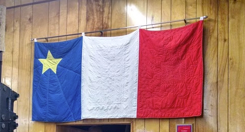
1. I kept seeing telephone poles that look like this. Why? What's up with this design?What does it signify?(And... for the curious folks, why does this make me think of Louisiana?)
To answer this question I just did the obvious first search, using terms that described what I saw. (Note that I didn't include the term "telephone pole" because I wanted to start broadly, and I wasn't sure if they called the pole a "telephone pole" or something else--better to start broadly and then narrow down).
[ nova scotia gold star blue red white stripes ]
Luckily, this let me to the Wikipedia list of Canadian flags, which includes a description (and image) of the Flag of Acadia, which looks exactly like this telephone pole. (It's worth knowing that I saw this flag a LOT in the St. Peter's / L'Ardoise region of Nova Scotia.
And, for confirmation, I found this flag on the inside of the building behind the telephone (in the image above).
Here's the location of the telephone pole in Cape Breton:
And the StreetView of the Community Center, with the pole obvious in the foreground:
As for the connection between this part of Canada and Louisiana, I did the obvious search:
The name of the parish is derived from the former French colony of Acadia in Canada (which consisted of the modern provinces of Nova Scotia, Prince Edward Island, New Brunswick, and much of Maine) many of whose French-speaking inhabitants were deported to France and then migrated to Louisiana in the Great Upheaval (see Cajuns).
I'll let you dig into the details here, but in short, the Acadians were forcibly expelled from the present day Canadian Maritime provinces of Nova Scotia, New Brunswick, and Prince Edward Island —an area also known as Acadie. This happened over 10 years (1755–1764) during the French and Indian War as part of the British military campaign against New France. The British first deported Acadians to the Thirteen Colonies (remember, this is pre-US), and after 1758 transported nearly all of the Acadians to the colonies, Britain, and France. Afterwards, many of them relocated to Louisiana, where the Cajuns trace their roots to the influx of Acadian settlers after the Great Expulsion from Nova Scotia. Since moving to Louisiana the Cajuns have developed their own dialect, Cajun French, and you can still hear the effects today.
As I was driving around part of Cape Breton I turned on the car radio to the local FM station and heard this song. My French is terrible, but I understood enough to get the gist of the song:
Which includes the lyrics:
Chorus: Acadie à la Lousiane; Un grand voyage pour notre monde Pour trouver la liberté Et un beau pays
(Translation: Acadia to Louisiana, a long voyage for our people; to find liberty and a beautiful land.)
2. More than once I heard a local say "..I'm going down to the north..." This struck me as funny because I thought the convention was that north was up. What could a Cape Bretoner mean by this phrase, "I'm going down to the north..."?
When searching for a phrase, I usually start by just quoting it, like this: [ "going down to the north" ] and seeing what I find. In this case, I found lots of things, but none of which were especially useful. My only strategy at this point was to shift to Google Books and start adding in additional terms that I was hoping would limit the results to what I needed. Here's what I tried: [ "going down to the north" Cape Breton ] [ "going down to the north" Newfoundland ] [ "going down to the north" Canada ] [ "going down to the north" expression ] None of these really worked well. But I kept at it, and then finally I tried: [ "going down to the north" maritimes ] I struck gold with that last one, finding that "...in some parts of the Western Isles of Scotland, it is not uncommon to hear islanders talking about going “down” to the north and “up” to the south." That's relevant because Cape Breton is ALSO populated with a lot of Scots who migrated to the area during the 1800s, so they well could have brought along this standard usage. But that's a bit tangential. Could I find something more direct? When doing repeated searches like this, I will often back off a little on the use of quotes. So my next search was: [ down north Cape Breton ] and--lo & behold--I found several pages that discuss the Cape Breton idiom of "doing down north" with the explanation (from the Canadian site):
"Cape Bretoners talk about Down North – diametrically contrary to most people who go “down south” and “up north.”... Let’s overlook the finer points of the compass! Let’s think wind. In the age of sail, if you wanted to sail Lake Bras d’Or from Baddeck northeast to Sydney, for the majority of your journey you would make use of the prevailing wind which blows most commonly from the southwest. Thus you would be sailing “down wind” and therefore (sort of) “down north”. Logically, therefore, on your return trip you would be sailing “up” to Baddeck against the prevailing wind.."
In this way I also found the book, Down North and Up Along, which describes going "down north" as applying to any journey northward from the southernmost point of Nova Scotia.
3. I visited a few small fishing villages and noticed that they have a particular kind of fishing boat. I wondered if this was particular to Cape Breton, or if it's more broadly distributed. So... what's a typical Cape Breton fishing boat design?
I started this Challenge by searching just for: [ Cape Breton fishing boats ] but found that the results were overwhelmed by boats for sale, or offers for fishing charters. Clearly, I needed to be more specific. I shifted my search to: [ Cape Breton fishing boat design ] and found lots of great results. Including this nice article at the Canadian Museum of History about Nova Scotia boat design. This tells us that Cape Breton fishing boats "...have a curved top cuddy and graceful, single shear." And that "...A distinct feature of wooden Nova Scotian boats was the hollow or built-down skeg; elsewhere builders made a solid wood deadwood. It was a lighter more buoyant hull and always a feature of "Novi" boats, as they were known throughout Maine." To understand this, you have to know that a "cuddy" is the cabin on the boats, and that a "skeg" is a fixed fin at the bottom of the boat. (Like a small stabilizing fin running along the bottom of the keel.) An Image search also shows some distinctive Cape Breton boats. Notice the nearly vertical bow, and the deck in the back. These aren't big boats, but the design is clearly Cape Breton.
Search Lessons
1. Pay attention to the things you see in the world. I don't know about you, but painted telephone poles are an unusual thing to see, and when you see a bunch... well, you should start asking questions. Why? 2. A great way to find a song you heard on the radio is to search for a distinctive lyric... on YouTube. I'm always impressed at how well this works. In this case, I found that song I heard, in Cajun French, on YouTube. 3. Sometimes you just have to do a bunch of searches. When looking for the "down north" explanation, I probably did 12 searches before I found one that got me somewhere. I was able to do this quickly, just doing a broad survey of available results. A key thing to remember (especially if you're a student): Sticking with it sometimes takes a little time. But it's completely worth it. 4. Try going to a less restrictive search when things aren't working out. As you saw in the above example, to really get a good result, I had to NOT use double quotes, even though I initially thought they were necessary. Remember to try backing off (removing double quotes, or removing search terms that aren't as helpful as you believe) as a strategy. 5. Contrariwise, sometimes you have to ADD in a term to exclude results that are getting in the way. That was the case when I had to add the term "design" to find information about Cape Breton fishing boats; it was the only way to actually get to results that were useful. Search on!
Cape Breton... ... is a beautiful place on the northeastern end of Nova Scotia. I was visiting there last week, driving around enjoying the local music and the fall colors.
But as usual, there were things there that puzzled me--can you help me understand what I was seeing and hearing?
1. I kept seeing telephone poles that look like this. Why? What's up with this design?What does it signify?(And... for the curious folks, why does this make me think of Louisiana?)
2. More than once I heard a local say "..I'm going down to the north..." This struck me as funny because I thought the convention was that north was up. What could a Cape Bretoner mean by this phrase, "I'm going down to the north..."?
3. I visited a few small fishing villages and noticed that they have a particular kind of fishing boat. I wondered if this was particular to Cape Breton, or if it's more broadly distributed. So... what's a typical Cape Breton fishing boat design?
These Challenges can be a little tricky, so I'm really curious about what you do to answer these Challenges. Be sure to let us know HOW you solved these! Search on!
Non-watery fountains? This week's Challenge was fairly simple, but could be as open-ended as you want. It came about when I saw some non-water-based fountains, and was struck by how crazy they could be. In particular, I found one fountain that deeply surprised me--it was this first one...
1. Can you find a (man-made) fountain that uses a toxic metal as its "water"? How made it? Where is it? And why on earth would someone make such a crazy thing? (I was rather surprised when I found this one; I suspect you will be as well.)
This Challenge wasn't all that hard the query: [ toxic metal fountain ] quickly leads one to several articles about Alexander Calder's 1937 fountain made of mercury. You can quickly learn that this fountain, made of flowing liquid mercury, was commissioned by the Spanish Republican government for the 1937 World Exhibition in Paris. The artwork is a memorial to the siege of Almadén (which then supplied most of the world's mercury) by General Franco's troops. The mercury fountain, now at the Fundació Joan Miró in Barcelona, is now displayed behind glass for safety reasons. Here's a short video of the fountain in operation:
At least one person noticed that I used to work at the IBM Almaden Research Center in San José, California. The lab is named Almaden after the region where it's located, New Almaden, CA, which was in turn named after Almadén, Spain. New Almaden was well-known for its large mercury mining operations, which supplied mercury for gold mining operations in Gold Rush-era California (late 1840's).
2. (extra credit) What would a strategy be for finding other fountains that use other "non-water" substances as their flowing / squirting / splashing element? How would you find other things in this "non-water" category?
This was a bit more tricky, and I still haven't found the perfect strategy, but here's what I did. I started with queries that did various pattern-matches: [ "a * fountain" ] but that wasn't so productive. There are too many low-quality hits. Then I tried various versions of the AROUND operator, such as: [ "flowing" AROUND(3) fountain ] and that didn't work well either. Too many poetical uses of those terms near each other. I realized that perhaps a better solution would be to try and use language that would be in an article that talked about non-water fountains. So I went back to the mercury fountain article (from above) and looked at the text carefully. In that article I noticed that the writer pointed out that this fountain used "...mercury instead of water..." So I tried that next: [ "a * fountain" "instead of water" ] and an additional variation: [ "a * fountain" "rather than water" OR "instead of water" ] I used the "a * fountain" to find articles about fountains that were of a particular kind, then added in the expressions that would most likely be used in articles that specifically mentioned that it was different than a water fountain. This approach worked pretty well. I found the mercury fountain (of course), but also mentions of hypothetical "codeine fountains" and ideas about "oil fountains" as well as "soda fountains," fountains of wine, vodka, chocolate, run, milk, lemonade, and--surprisingly--sand. Here's one kind of sand fountain, where the sand is pumped up from below:
But also a kind of sand fountain I hadn't thought about before... an underwater fountain of sand cascading down inside of an aquarium:
Since this strategy was working well, I thought I'd try this same query in Google Books, hoping to find some really novel kinds of fountains that were well-described there. For Books, I did the search: [ fountains -"fountain of youth" "fountain of *" "flowing *" ] I had to minus-out the phrase "fountain of youth" because I was getting too many off-topic hits. Surprisingly, this strategy worked really quite well: I was able to find mentions of a "fountain of molten copper" in a concordance to the Qur'an, and fountains of blood, pitch, and bitumen described in an 18th century book, "The Universal Library, Or, A Compleat Summary of Science."
Search Lessons:
The first Challenge was pretty straight forward. It's good to have these every so often--I mean, who knew that someone would be crazy enough to make a mercury fountain?? But the deeper lesson in the second Challenge is this: 1. Sometimes you want to use characteristic language in your search. In this case, the phrases "rather than water" or "instead of water" are going to typically be found in such descriptions because the article is describing an exception to the ordinary. As always, the general idea is that you want to search for the language that will be in the web page you seek. Remember this when you're stuck on a really hard search task! Seach on!
And of course... remember there are natural fountains as well. In this case, a gusher of oil from Baku...
And at Pu`u` `O`o vent on Kilauea Volcano, Hawai'i.
This past week I saw a small fountain of molten chocolate at a hotel reception. You know, the kind you hold your skewered piece of fruit beneath, and then, as you try to eat it, the chocolate drips everywhere. If you're not careful, it will end up on your clothes and you'll be wearing an outer shell of solidified cocoa essence. But I also found out that fountains need not be just devices for shooting water (or chocolate) into the air. I've seen fountains of caramel (a VERY sticky mess), and even champagne. This week's Challenge is fairly simple, but can be as open-ended as you want.
1. Can you find a (man-made) fountain that uses a toxic metal as its "water"? How made it? Where is it? And why on earth would someone make such a crazy thing? (I was rather surprised when I found this one; I suspect you will be as well.)
2. (extra credit) What would a strategy be for finding other fountains that use other "non-water" substances as their flowing / squirting / splashing element? How would you find other things in this "non-water" category?
Let us know what you find, and HOW you found it! Search on!
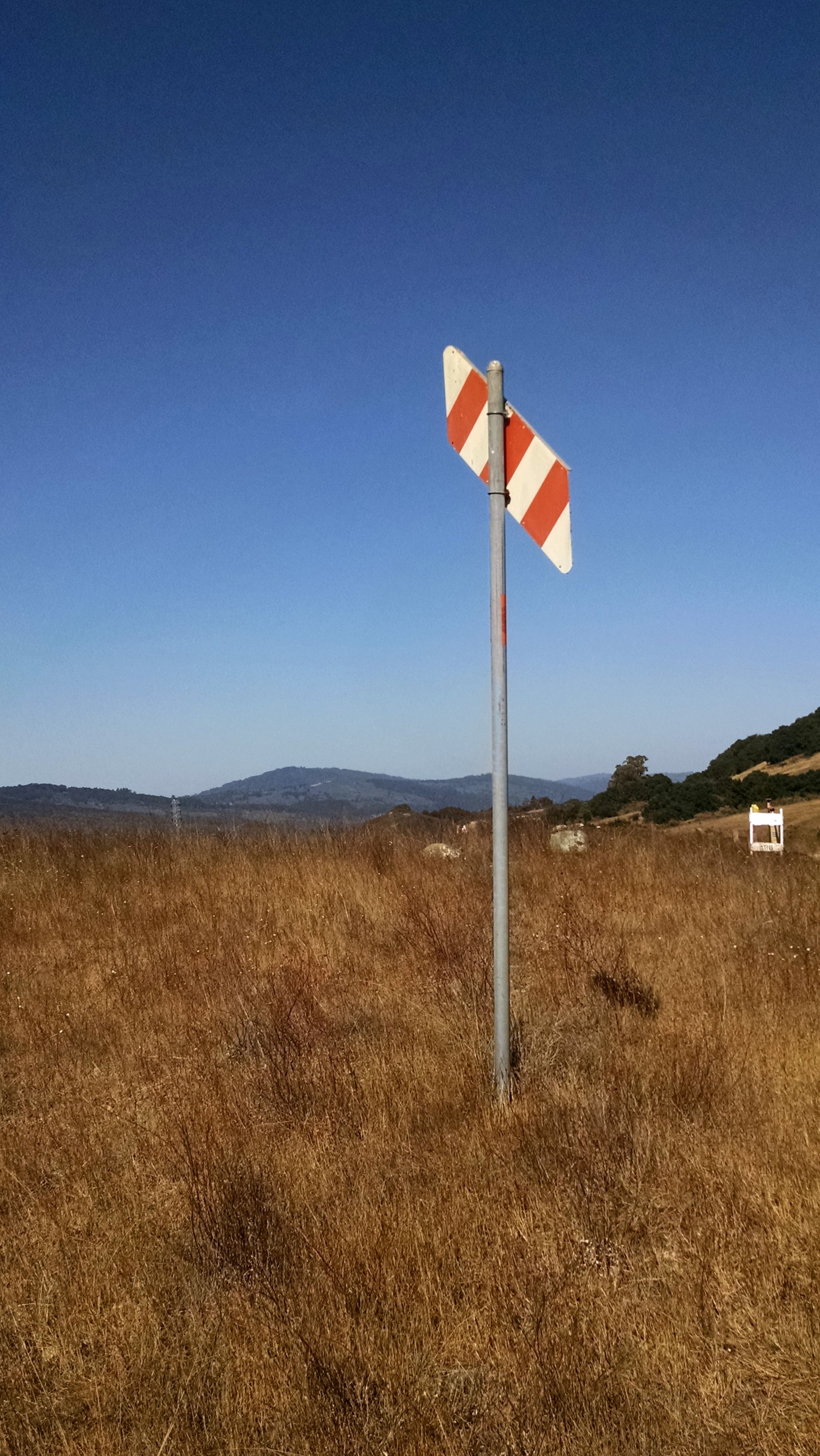
Mysterious signs... ... are everplace in our lives; this just happens to be one that I got curious about. And as it goes with human cognition, once I saw this sign while running, now I'm seeing it just about everywhere I go. More generally, once you've solved a Search Challenge like this, you'll start to see LOTS of signs in the world that you do not recognize. One of the skills to learn in this Challenge is how to identify those previously unknown signs and symbols. Let's start with the sign...
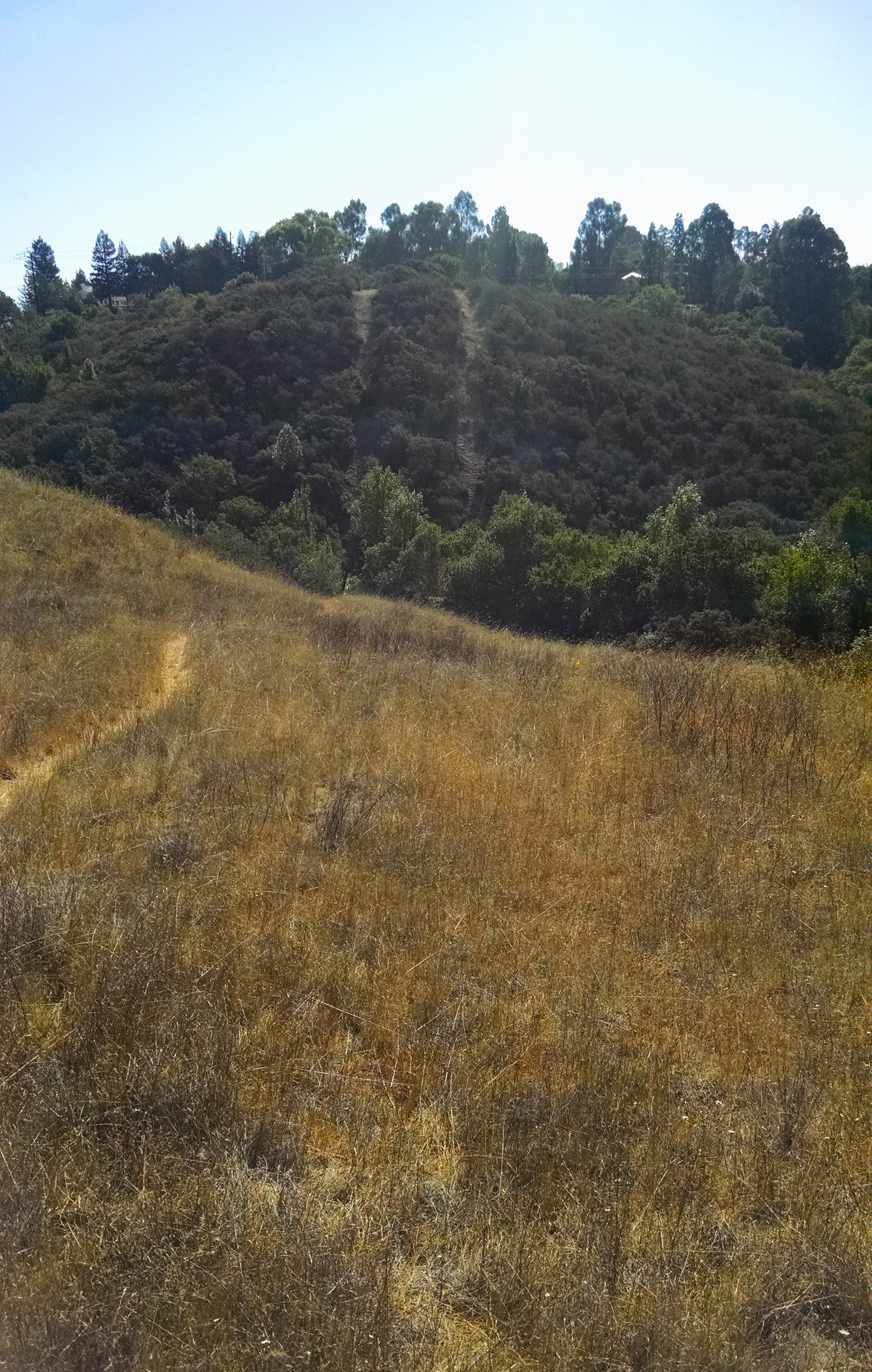
As I said, it's just out in the middle of a field near a nice trail. Then, looking south east from this marker, I saw the following hillside:
1. What does this sign indicate? Why would someone post this in the middle of an empty field?
2. What's up with the two trails to the south? Why are they there?
3. Can you figure out why that small caution sign is there in the middle right of the first picture above?
What's the sign indicate? To solve this, I right clicked on the image (or Control+click) to get the URL for the image. I want to get the EXIF metadata from this image, and my first search after copying the image URL is for: [ exif metadata viewer ] (Remember this from an earlier SRS post?) The first one on my results list is Jeffrey's EXIF viewer. When I drop the URL into the box, I see this:
and if you scroll down far enough, the app shows the map location. But here is also the "Location guess from the coordinates" (Clarkia Trail, Redwood City) and the lat/long: 37.461619, -122.282336. I just drop those into Google Maps and see:
Now click on the "Earth" view button (lower left) to see what this place really looks like:
The red bubble is the location of the camera when I took the picture. If you zoom in, you can see the shadows of the sign... (number 1), and of another sign right beside it (number 2).
Now... what's going on there? What could those signs indicate? My first query was: [ Clarkia Sunset trail signs ] which gives a nice set of results, the 5th of which is:
This looks interesting--maybe it's what we're looking for in Challenge question #3! This article tells us that:
"Pacific Gas and Electric has begun hydrostatic pressure testing on the pipeline located in Edgewood County Park and Natural Preserve and will continue until mid-November, according to San Mateo County Parks Department officials.
Work will take place in three locations along the Sunset, Edgewood and Serpentine trails and at the Clarkia trail junction. The park’s Sunset Trailhead will serve as the access point for project crew and equipment. Pipeline testing is expected to be completed in mid-November. Trails will be open during the project. However, periodic trail closures will occur when equipment, including PG&E and contractor trucks, must be moved. Signs will be posted on trails when this occurs, according to the Parks Department."
From this we get two big clues about the Challenge: First, that the sign in question might well indicate the presence of a gas pipeline, and second, that they will be posting signs when this happens. Note that the date of the posting is August 27, 2015--not that long before I took the photo. Can we find a map of the gas pipelines? [ PG&E gas pipeline map ] takes us quickly to their interactive gas pipeline map. Here, I've zoomed into the Edgewood Park area. Take a look:
FWIW, this is as close as the PG&E map will let me zoom. But you can see that there are 2 pipelines going right through the intersection of the Clarkia and Sunset trails. So now we know that there are gas pipelines there, and that work is currently going on to test them. Let's double check to see if that diagonal orange/white sign actually means what we think: image search: [ orange white stripe sign gas pipeline ] leads us to a page that comments on these markers. "The markers, 10-foot poles with an orange and white striped “paddle,” are placed in agricultural areas in particular, and indicate the approximate location of the underground pipeline, serving as a reminder for people to be careful when working nearby. The paddle markers are aimed at providing a more visible line of sight indicator for both landowners and PG&E. The paddle part points downward to the location of the pipeline." (These markers are important. More than one disaster has happened because a construction crew dug up a high-pressure gas transmission line.) By doing a simple follow-up search, we can learn a lot about the pipeline through Edgewood Park. [ PG&E gas pipeline Edgewood Park ] We can learn the numbers, and again, from a Friends Of Edgewood Newsletter:
"PG&E is required by the California Public Utilities Commission (CPUC) to perform occasional safety testing on their pipelines. In the case of Line 109, the older of the two lines that run through Edgewood, this testing consists of removing gas from a segment of the line, then filling it with clean hydrant water, pressurizing it to 150% of the normal gas pressure, and assessing its integrity. This procedure is called hydrostatic pressure testing, or simply hydrotesting. In order to do this test, PG&E needs to access the pipeline by digging at 3 different locations inside the park (and at a 4th location just outside the park in Woodside).
2 of the digs are 6’x6’ “sniff” holes that we expect will create minimal disturbance, but the third dig is a much larger “bell” hole that will cause a greater impact. Referring to http://photos.foew.org, the locations are:
First sniff hole. PG&E refers to this location as Location C. It is at the intersection of the Clarkia and Sunset Trails in map quadrant L-11...."
(Emphasis mine.) Their annotated map is at the bottom of this page:
From the Friends Of Edgewood Newsletter.
Now, what about the 2 trails? By looking at the Earth view up close, you can see that these are the tracks of pipelines 109 and 132. Just out of curiosity, I looked up [ PG&E gas pipeline 132 ] and discovered a PG&E map showing where it runs, along with some color coding to indicate if it's been tested recently, or if it's under review. Somewhat disconcertingly, both of these pipelines run within a couple of blocks of my house! (And worse, they're a couple of places marked in orange, meaning "Pipeline segments in high consequence area under review. Good to know they're testing these pipes!)
But I digress. We've found the answers. The sign is a marker for a high-pressure gas pipeline owned by PG&E. The two trails are the access roads for pipelines 109 and 132. And the caution signs on the trails are to mark the presence of sniff holes so the testing can proceed.
Search Lessons:
1. EXIF metadata is your friend. Especially for photos that are in the middle-of-nowhere, grabbing the metadata (such as through Jeffrey's metadata viewer) will get you started. Once you have the lat-long you can... 2. Make use of places and names found on the maps. In this case, we used the name of the park (Edgewood) and the trails (Clarkia and Sunset) to find other articles about work going on in that location. Note that we also checked the date of publication and when the work was going on. (It would have been less helpful if the newsletter had been from 2 years ago, but we were lucky in that it was current.) 3. Image search for a marker is easy, especially if you know what kind of thing it's marking, OR the company name. Interestingly, search-by-image was difficult to do with this image. I tried various clipping / cropping and nothing really worked well. But searching with a very descriptive query, [ orange white stripe sign gas pipeline ], actually worked very well. This was a great Challenge. Hope you enjoyed it as much as I did! Search on! P.S. And just as a bit of ground truth, here's a picture of the OTHER sign (sign #2 in the above Google Earth image). We were right!
While running... ... in a nearby open space preserve on the San Francisco peninsula the other day, I came across a somewhat mysterious sign.
I figured this must mark something pretty impressive, because it's just out in the middle of a field near a nice trail. Even more strangely, when I turned around and looked south east from this marker, I saw the following hillside:
You can see the trail, and then on the hillside across the little valley, I can see two parallel tracks. They look like trails, but when I went over there, I found a fence blocking my path with a "no trespassing" sign. Huh. Naturally, I'm curious. Can you help me figure out what's going on here? This week's Challenge is about starting with one piece of information and then working from that to another, and another, and another.
1. What does this sign indicate? Why would someone post this in the middle of an empty field?
2. What's up with the two trails to the south? Why are they there?
3. Can you figure out why that small caution sign is there in the middle right of the first picture above?
Any ideas? I found this to be pretty interesting, in part because I had no idea what these kinds of signs are all about, and it opened up a whole new whole of things I'd never thought about before. Hope you find this Challenge equally engaging. When you figure it out, be sure to tell us HOW you found out! Search on!