This kind of question is difficult to answer...

The Challenge was: "Why is the Carquinez Strait so undeveloped on the south side of the channel?"
As evidence, I made this map to highlight the area that is still most open range lands.

I noticed that while there's a lot of development (houses, shopping centers, etc.) on the north side of the strait, there's very little on the south side.
Here, a couple of place names leap to the fore: "Port Costa" "Crockett Hills" (a regional park), and "Carquinez Straits" (another regional park), "Martinez." If you zoom in a bit more, you'll also see "Bull Valley" and "Eckley" as other place names of interest.
On this plat you can see a note marking "Ramon Estudillo's home" in the upper left, as well as "Big Bull Valley" and "Little Bull Valley." These names might come in handy later, so I write them down on my notes.
 Contra Costa Assessor's map of parcel 368-100-002, just south of the town of Port Costa.
And of course, by 1916, the Rancho was largely up for sale.
 From San Luis Obispo Daily Telegram, Dec 16, 1916
And if you keep searching, you'll find the sales, transfers, and gifts that were made over the years. 200 acres here, 159 there--but always as unimproved land on the margin of the main rancho.

As you can see, they have very different views on what's going on the old Rancho. The Crockett Hills Regional Park is the same, but the De Martini Ranch isn't marked on the OSM plan. And, as you can see, the bulk of the Rancho is either Di Martini ranchland, or preserves.

I noticed that while there's a lot of development (houses, shopping centers, etc.) on the north side of the strait, there's very little on the south side.
So... why is there such a big gap between Crockett and Martinez, a large region of undeveloped land. Let me repeat this week's Challenge:
1. Can you figure out what's going on in this stretch of otherwise unused coastline? Is it really the "Lost Coast" of the North Bay? Why so... empty? What didn't happened here?
As I mentioned, getting simple answers to questions like this can be difficult. This is the dog that didn't bark--the missing piece, a non-event, a gap in what otherwise seems like a normal path of progress.
To answer this, we're going to have to create some counterfactual rationale--that's the kind of question you get when you suppose that something didn't happen, and ask why it didn't. So, what prevented the south side of the strait from being more developed? (Or, ask Sherlock Holmes might have said as a counterfactual question, "Why didn't the dog bark?," sometimes referred to as the "curious incident of the dog in the night time.")
My first thought was to try and see some archival images and maps to see what we might see. Of course, I turned to Google Earth and its collection of archival images. Here are 3 images of the area that I've marked up with a dashed line to indicate where development DID occur.
 |
| Google Earth - 1939 |
 |
| Google Earth 1993 |
 |
| Google Earth 2021 |
With these three maps I was checking to see if perhaps there was some underlying geological reason that would make this area un-developable... but I don't see anything. What's striking about this dashed line is how much it looks like the random rectangles you see in city-use planning diagrams. There's a blob sticking into the Rancho in the lower right, and the edge isn't one long straight line... it's pretty ziggy-zaggy.
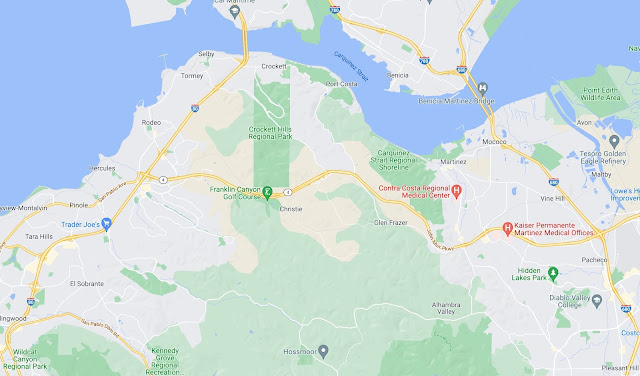
Here's a Google Maps version of the same area today shown as a traditional map. Here what I'm looking for are place names that I can use to do searches of archival content.

Here, a couple of place names leap to the fore: "Port Costa" "Crockett Hills" (a regional park), and "Carquinez Straits" (another regional park), "Martinez." If you zoom in a bit more, you'll also see "Bull Valley" and "Eckley" as other place names of interest.
For each of these place names, I did a small deep dive, usually starting with a query like this:
[ history Port Costa ]
[ history Eckley ]
[ history Martinez ]
My goal in doing these dives is to learn as much about the place (history, dates, people, place names) as possible. I keep a little running set of notes as I do this just to keep them all straight. (Truthfully, I do this on a piece of paper. It's fast, easy, and I can easily makes edits and links to other things as they come up.)
To tell the truth, I spent a few very pleasant hours doing this, following interesting stories as they came up, but mostly learning that this triangle of land never seemed to have much development on it.
My first dive was to figure out who owns this part of California. My dive research told me that this area was called Rancho Cañada del Hambre y las Bolsas. (I found this out after seeing several maps from the late 1800s with that as the place name... see below.) The ranch was a 13,354-acre (54.04 km2) Mexican land grant that was given in 1842 by Governor Juan Alvarado to Teodora Soto. The grant consisted of "Cañada del Hambre" which means "Valley of Hunger" in Spanish, and "Las Bolsas del Hambre" which refers to "pockets" of land.
The rancho extended from present day Crockett to Martinez and south to Lafayette.
Here's a section of the plat from 1866 that I found at the Online Archive of California by searching for:
[ plat Rancho Canada del Hambre ]
(Why the word "plat"? Because I know that term means a kind of large-scale map often used in land surveying and land-use planning. It's specialized language.)
 |
| Plat of the rancho, 1866. |
On this plat you can see a note marking "Ramon Estudillo's home" in the upper left, as well as "Big Bull Valley" and "Little Bull Valley." These names might come in handy later, so I write them down on my notes.
But I kept looking for more vintage maps, searching through the results of my search:
[ maps Contra Costa county ]
By just clicking through the images, I was able to find several over the years.
Here's one I found on Wikipedia: as you can see, 30 years later, some development has taken place along the north (the towns of Crockett, Aldona, and Port Costa), and most significantly, to the east (Martinez).
 |
| Rancho Cañada del Hambre (1894) per Wikipedia, USGS Karquinez Quad. |
And below is another survey from 1898, just a few years later showing even more development, especially in Benicia and Port Costa. There are also sections marked off.
 |
| Rancho Cañada del Hambre (1898) Theodore Wagner and company. Here you can see major divisions of the land, in some cases showing who bought them, such as "McNear" in the lower right. |
The first thing I noticed after I found these maps was the immense similarity to my original chart (second figure from the top). What are the chances? I didn't know about this Rancho when I drew that diagram... I was just highlighting the blank spot on the map.
Of course, I did a search for the history of Ranch Cañada del Hambre, and found a Wikipedia article, this told me that the grant for the rancho made to Teodora Soto was "sobrante," (that is, a remainder after the Rancho El Pinole on the west and the Rancho Las Juntas on the east were sold). It was estimated that the sobrante would contain three square leagues of land. (If you ask Google [ 3 square leagues of land in acres ] you'll find that it's 22,000 acres, Teodora Soto was married to Desiderio Briones. (Now that's interesting... Why? Because the grant was made to a woman, which wasn't much done at the time, AND we've seen that name, Briones, before. Desiderio was the nephew of Juana Briones, who owned land in San Francisco at this time. See SRS from March 8, 2018-- "How did this group of houses get to be here?" Two powerful Californio women who end up related to each other?)
In any case, after the Mexican-American War, the 1848 Treaty of Guadalupe Hidalgo provided that the Mexican land grants would be honored. As required by the Land Act of 1851, a claim for Rancho Cañada del Hambre y Las Bolsas was filed with the Public Land Commission in 1852, and the grant was patented to Teodora Soto in 1866.
I spent many happy hours looking up who owned which parcel of land, and where it went... but we're REALLY interested in why it's undeveloped today.
I was curious if this land was EVER developed, so I started searching for maps of Contra Costa county. I did the usual library searches (the Library of Congress has a great map collection of the area), but oddly, I found that the best source of maps during the time-span of 1900 - 2000 was.. Etsy and eBay!!
Yes, there are LOTS of maps of Contra Costa County from all during that century. Here are just a few of the many I found using the eBay search:
[ Contra Costa county map 1970 ] -- or whatever year you'd like
| A map from eBay, published by Chevron in 1970. It shows a large, still undeveloped section of Contra Costa county south of Crockett and Port Costa, west of Martinez, and east of Rodeo. |
 |
| Another map of the area from 1990, published by Gousha, again showing a blank space. Sorry this is so low res--it's the best I could find--but it's convincingly empty. You can clearly see Port Costa at the top. It's a small village, and if it shows up on the map, then other villages in the blank space would have ALSO appeared... and they don't. |
In any case, all of these maps show the old Rancho as agricultural lands. Clearly, the Rancho was divided up, and kept as farms or ranches over the years.
Another approach would be to search for land use maps. "Land use" is often used to describe how land is zoned and how the city or county or state plans to use that area. A search for:
[ land use map Contra Costa county ]
leads to this current map from the county government, showing the zoning / plans for land use in the county:
 |
| Current (2021) land use map of north Contra Costa county. Here, blue is public/semi-public lands (such as highway right-of-way), while green is parkland/preserves. The pea-soup green is marked as "agricultural" land. P/C Contra Costa County. |
Perhaps part of the answer can be seen in who owns these parcels now.
The easiest way to learn that information is via the county assessor's office. (Why the assessor? They have all the information needed to assess the taxes on a piece of land. And usually, in the US at least, they also offer a web-site with a GIS system to find out about each parcel.)
A search for:
[ Contra Costa county assessor ]
leads quickly to the Assessor's website, and it's a single click to get to the GIS tool that lets you lookup ownership of land parcels.
Here's an example:

If you poke around in the Assessor's map, you'll find that all of the parcels are all labeled as agricultural land, reserved in a "Land Bank" (set aside by the local government), parklands, or are federally owned (especially along the waterfront). So the Assessor's map (who you would plausibly has ground truth) algns with the land use map above.
But how did it get to be this way?
If we look back into the newspapers of the day, you'll find the record of many sales published in the local press. (Back in the day, land transactions had to be published to become part of the public record.) If you search in Newspapers.com (or your favorite digital news archive, which for me is the California Digital Newspaper Collection).
If you do the obvious searches (e.g., [ Rancho Canada del Hambre ] or [ Rancho Briones ]), you'll find a LOT of land transactions. Here's one such sale (part of my deep dive taught me that Rancho del Pinole was just to the SW of Rancho Canada del Hambre):
 |
| Contra Costa Gazette, May 24, 1907 |
But some of these notices also tell us who owned what, and when, and how much they owned. In the San Francisco Call of March 20, 1907, I found this notice of someone applying for a mortgage:
 |
| George McNear mortgaged 3866 acres (his part of the Rancho) to raise some quick cash. |
And of course, by 1916, the Rancho was largely up for sale.

And if you keep searching, you'll find the sales, transfers, and gifts that were made over the years. 200 acres here, 159 there--but always as unimproved land on the margin of the main rancho.
There are two other resources I turn to for this kind of geographical information in an attempt to complete the story: Wikimapia and OpenStreetMap. Both are collaborative efforts to crowdsource all kinds of geodata, and since they're slightly different, you can sometimes find gold in the different views. Here's the Wikimapia view:
 |
| You can see that in Wikimapia's view, the rancho is either parkland, ag land, or John A De Martini land, still held as a ranch. |
By contrast, here's the OpenStreetMap's perspective:

Bottom Line: How did this all stay so undeveloped?
There isn't a single neat, short answer, there usually isn't for counterfactual questions. But the case is pretty clear that this area has always been seen (and valued) as agricultural land, even as it was being broken up and sold off in smaller fragments. Remember that in the late 1800's and early 1900's, this ranchland was also intensively farmed for wheat... which was then shipped out through Port Costa until the bridges made it easier and cheaper to use railcars.
Basically, the story seems to be this: Over the years, several families had large tracts of land that they slowly sold off, but almost always for ranching or farming uses. From the 1970s until today, some of those sales and gifts were to the county for the purpose of preserving open space. That's ultimately how the Crockett Preserve and the Carquinez Straits Regional Shoreline came to be.
This post is already pretty long: So I'll write up the SRS lessons tomorrow. Stay tuned!
Search on!
Great project, Dan. I still wonder what was missing (for the Spaniards) that it was named Rancho Cañada del Hambre y las Bolsas. This is a dandy Search. Worth an article in a learned Journal or SF newspaper. j
ReplyDeleteDBpedia - Valley of Hunger
Deletepossible?
"The original portion of the rancho, “Cañada del Hambre,” was probably named by early Spanish explorers and is translated “Valley of Hunger.” The reference was to the many canyons in the area through which the near-starving explorers passed."
I can only remember the citizens of Port Costa (my Parents included) fought long & hard to keep our hills (our back yards) from being developed by Arabs (they called these developers)... thus our hills became property of Carquinez Regional Park sometime in the 1970's - 80's. I never heard rumors of these hills ever being deveoped, but my Grandfather Engineer Earl Fosgate & his younger brother Samuel planted young Eucalyptus trees that no body wanted that came off of their train. We love those trees & the Bay trees - Our Hills Are Majestic & Quiet With Lakes & Crystal Caves They Once Mined. It's A Land Away From The Hustle & Bustle Of Contra Costa County & The San Francisco Bay Area. THANK GOD, OUR TOWNSFOLK & GRANDPA EARL!!!
ReplyDelete