A blog about search, search skills, teaching search, learning how to search, learning how to use Google effectively, learning how to do research. It also covers a good deal of sensemaking and information foraging.
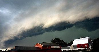
Yesterday's search challenges: 1. (easy) What kind of a cloud is this? (And what's theother name that they're often called?) There are many ways to answer this ranging from the ridiculous to the sublime. First, the ridiculous method. A. Images are often given descriptive file names that can be useful. For instance, if you right click (PC) or control-click on the above image and select "Save image as" you'll see the original file name given by the author (in this case, me, when I saved the image file while writing the original post) as the suggested filename. Now THAT's a big hint! It's probably a roll-cloud. (Although of course you'd do the obvious search to confirm that.)
B. Ordinary keyword search. As I've said before, often the best strategy is to just describe what you see and search for that. In this case, a simple descriptive search for: [ long cloud ] in Image search gives you this:
which also leads quick to identifying this as a roll cloud. (You even see our lead photograph as the 3rd hit in the image search.) C. Search-by-Image. Using that right-click/control-click trick (see A above) you can save the image to your local disk, then use search-by-image to upload the image file and search for it that way. See my 1MM video post about this. By this point, you should know it's a roll cloud, also-known-as a morning glory cloud in Australia. And by this point you've probably already read the Wikipedia article on arcus clouds and know that a roll cloud is a specific type of arcus cloud. 2. (medium) If I only have 2 weeks for my vacation, where do you recommend I travel so I'll have a high chance of seeing them? When should I go there? If you've read around on this topic, you've probably seen multiple references to roll clouds occurring frequently in Queensland Australia. That's a big hint to you that there's something going on in that part of the world. A quick search for: [ Queensland roll cloud ] yields a rich set of hits, all pointing to the Gulf of Carpentaria as the breeding ground for roll clouds / morning glory clouds near the village of Burketown. The roll clouds happen regularly enough that glider pilots from around the world come there to fly up around these spectacular clouds. That suggests a trip to Burketown, although given how remote it is, I'm going to want to REALLY see these clouds. 3. (harder) Can you find out if these cloud formations are happening now? Prove it with some current imagery! (Meaning, pictures from this week.)
When searching for something that's time limited, the search date filter is your tool of choice. Now, what's a little surprising (to me) is that when I checked Images, the results were not so great. Sure, there were lots of images in that date range, but they were mostly people making posts about roll clouds. So it's true, but not helpful. Instead, the go-to source for this kind of thing seems to be Video! When I did my date-restricted search on Google Video, I found a lot of great examples taken in the past week.
Interestingly enough, several of these videos (from this week) are from Canada. Our neighbors are having some spectacular summer weather. Maybe I should be heading to Saskatchewan! Search lessons: 1. Try the simple things first. Picking up a hint from the filename seems too simple, but I find that it works a surprising number of times. (Except, of course, when the image filename is something like IMG003409.JPG) Likewise, the simplest possible descriptive search terms, [long cloud], is surprisingly effective. 2. Whenever you see repeated place names, take note. If you're seeing a place like "Queensland" mentioned over and over again, you might consider doing a search with that as an additional query term. The query [ roll cloud Queensland ] is remarkably good. 3. To find current events, a time filter on Video results is a great sampler. With video cameras basically blanketing the earth, this has become an impressive repository of the current state of everything darn near everywhere. And if YOU see a roll cloud in the sky, take a picture and send it in! Search on!
In case you missed it, Google Earth now has a "clouds free" view of our planet. The satellite imagery is usually created like a quilt; it's made by stitching together imagery of different parts of the world. In this case, Google has used USGS's and NASA’s Landsat 7 satellite—sometimes dozens of photos of a single spot in the world—and pulled together the images to prduce a clear view of every place, even in tropical regions that are always at least partly cloudy. The result is a single, beautiful 800,000 megapixel image of the world, which can be seen in both Google Earth and Maps when you're zoomed out to the global view. This image is so big, if you wanted to print it at a standard resolution of 300 dots per inch you’d need a piece of paper the size of a city block! Awfully pretty, and I thought you might enjoy seeing it. Note that we haven't removed clouds from ALL images at ALL scales--just at the largest one (and little by little, we're improving the other views as well). To get your own, go to Google Earth and zoom out.
in early spring, pollen starts to show up in the gutters.
In between the bursts of rain, early flowering trees—where I live it’s the plums, almonds, and acacia—all start producing pollen in abundance. It all washes down from the stamens, over petals and into the drains, leaving long strands of cadmium yellow along the rainwater’s edge. Fecundity’s promise, denied and discarded, but leaving brilliant streaky color along the way to sea.
In the San Francisco Bay area, those rains visit only between November and March, just five months of the year. Maybe because they’re so rare, they seem to bring wonderful moments of pure delight.
As I walked down the street just after a long rain, the sun emerged for a moment drenching the wet surfaces in warmth and light; a momentary pause in the rain that filled with brilliant sunlight. I turned around, looking away from the sun, hoping to catch a rainbow in the droplets reflections, but missed seeing anything. I kept walking. As I passed a tall pine tree, one drop fell off the tree limb into the sunlight, an aerial jewel. Then another, and another… until an entire shimmering cascade came off the long needles and into the shaft of light with a hush of quiet velvet sound. No rainbows in the moment, but there’s a curtain of falling crystals to see.
It was just an avalanche of raindrops; it happens constantly, nothing special in particular. But in that moment, in that quintessence of a fragment of time, I missed the rainbow, but saw diamonds in mid-flight, surging to the ground.
Earlier that morning I’d gone for a run at the Stanford Dish, it’s an open area featuring a gigantic radio-telescope, a landmark in Silicon Valley. But for locals, this is one of those standard runs you do often, just because you know exactly how far it is, what the trail is and what to expect. It’s not an exploration so much as it is a familiar ritual.
In rainy weather, though, it can be surprising. The Dish is in a hilly region of Palo Alto, with spectacular, open views in all directions. When it’s clear, you can see from San Francisco to San Jose (thirty miles to the north, thirty miles to the south) up and down the bay. To the west, the Santa Cruz mountains form a woodsy barrier wall. And when it rains, the clouds seem to always be especially dramatic from this hilltop.
Naturally, being a curious guy, I was thinking about that as I ran on the crestline trail. It’s where the views are best, and where the view of rain, clouds and sky are always most impressive. Why is it so consistently impressive? Is it just the openness of the viewshed?
On this run, this time, I noticed two patches of rain off in the distance. One was to the north, roughly over San Mateo, where there’s a gap in the western coastal mountains that lets the fog through in the summertime. The other rainy patch was to the south, roughly over Los Gatos, where there’s another gap in the mountains. An insight begins to dawn… Those two patches of rain are coming from the sea to the west, and are coming through the gaps in the mountains.
Of course! The reason the clouds are always so spectacular is that the Dish happens to sit between two major mixing points between the marine layer of air (coming through the gaps) and the air that sits in the bay (or in the summertime, that’s coming from the east, off the Central Valley).
In essence, this is the eddy between the mixers. Swirls, bumps, and lumps in the clouds happen preferentially here. Shafts of light that come through the breaks happen here as well, for just that reason—it’s an accident of geology.
The San Mateo gap is well-known. It’s what lets the summer fog over the mountains, often causing SFO to shut down. The gap at Los Gatos is also well-known—it’s where Highway 17 takes the low pass over the mountains to reach Santa Cruz.
When I get home I do the obvious thing and search for a rainfall density map of the Bay area, looking for confirmation that my gap theory is actually true. And after searching for a while (the key insight was to realize I needed a “precipitation” map, not a “rainfall” map), I found just the diagram I sought. And it’s true. Extending eastward from both mountain gaps are regions of increased rainfall. Los Gatos averages about 33% higher rainfall than the Dish, with similar numbers for San Mateo. Even better, the map shows a plume-like structure to the rain distribution: it’s the gaps causing the focusing of precipitation.
And now, naturally, being a curious guy, I wonder if there is a difference in the types of pollen you’d find in the gutters and waterways of Los Altos (to the south) and San Mateo (in the north) as compared to the location of the Dish. I suspect so.
That search continues. I will tell you that in the process of searching for differential pollen patterns in the Bay area, I learned a new word: palynology—the study of pollen… and its distribution. The word dates from 1944, and was coined in the Pollen Analysis Circular (a small journal that published from 1943 to 1954 and then merged with the larger publication, Micropaleontologist).
The question is, can I link geological features to pollenfall patterns? What kind of research would I have to do to get the answer? That’s the joy of finding stuff out—the chance to look at the world, do a bit of deep looking and digging in the literature, pulling together ideas, linking them together to learn something brand new.
I love doing research both professionally and at a small, personal scale. And I now know why running the Dish on a rainy day is almost always rewarding—it’s fertile ground for observing the world and launching into small personal research quests.
The next step is just connecting literatures between geography, meteorology, and palynology—a cross pollenization of academic disciplines, if you will.
... is one of those personality traits that some people find endearing while annoying others. Personally, I'm a curious person, so I find a curious person to be engaging and fun.
This week's Challenges are drawn from things I saw that made me say why is THAT the way it is?
Let's unpack these Challenges and see how curiosity helps us find some understanding:
1. Here's a pic I took the other day in my back yard. I live not too far from San Francisco International airport, so it's common to see contrails in the sky. But this one seems unusual to me. For lack of a better term, it's unusually poofy with lots of blobs along its length. What's going on with these poofs on the contrail? Does this happen often? Is there a name for this phenomenon?
This one of those fairly common moments in SearchResearch: what do you search for here? That is, what search terms are most likely to tell you what you need to know?
In cases like this, you have to count on learning as you search--picking up terminology that you can then use for your actual search.
I started with:
[ contrail puffy ]
led me to an article by the Royal Meterological Society (UK) called Contrail lobes or mamma? The importance of correct terminology, which seems singularly appropriate as I'm casting about for better search terms. This article talks specifically about the lobes that sometimes form on contrails.
As this article points out, the terminology is varied:
The lobular cloud regions in contrails have been variously called ‘drop‐like formations’ and ‘pendulous lumps’ (Ludlam and Scorer, 1953), ‘blobs’ (Scorer and Davenport, 1970), ‘pendant swellings like inverted mushrooms’ (World Meteorological Organization, 1975, p. 66), ‘pendules or fingers’ (Schaefer and Day, 1981, p. 138), ‘puffs’ (Lewellen and Lewellen, 2001), ‘clumps of condensate’ (Rossow and Brown, 2010), ‘smoke rings’ (Unterstrasser et al.,2014), and ‘tear‐drop structures’ (Paoli and Shariff, 2016). They have also been called ‘mammatus’ (Ludlam and Scorer, 1953; Schultz et al.,2006; Unterstrasser et al.,2014), ‘akin to mammato‐cumulus’ (Day and Schaefer, 1998), and ‘mamma structures’ (Paoli and Shariff, 2016).
This discrepancy in terminology in the literature (as well as public‐facing websites discussing contrails and meteorology) raises an important question as to what should be the appropriate scientific name for these features...
What should I use for my next search? Well, many of these terms are fairly common ("drop-like formations" can describe icicles as well as clouds). The big question for meteorologists is Why does a smooth cloud develop these lobes? In meterologist terms, What causes a mammatus formation in a contrail?
But since the term mammatus is fairly rare I tried:
[ mammatus contrail cause ]
And that led to a bunch of articles, all of which are fairly technical. Seeing so many tech-focused articles makes me think that we should look in Google Scholar (which gives us 52 hits for this query). But they're pretty good hits.
One paper in particular seems right up our alley: The Mysteries of Mammatus Clouds: Observations and Formation Mechanisms, by Schultz, D. M., Kanak, K. M., Straka, J. M., Trapp, R. J., Gordon, B. A., Zrnić, D. S., ... & Lilly, D. K. Journal of the Atmospheric Sciences, 63(10), 2409-2435. (2006).
Fortunately, this is an open access paper, so we can read it carefully.
As the authors write, sadly for us:
Because they are not directly related to significant weather events on the ground and they do not apparently hold insights into forecasting severe convective storms, mammatus generally have been viewed as no more than a curiosity in the atmosphere. Consequently, published research on mammatus is rather limited, and what literature exists is either highly speculative or severely constrained by the limited nature of the observations.
Well... rats! But I'm curious enough to read through the rest of the paper.
Pressing on, though, we read that in the "Mechanisms" section of the paper there are several different thoughts about why a cloud (such as a contrail) might form mammatus shapes. If we ignore the proposals for mammatus formation in anvil-shaped clouds (thunderheads and the like that don't apply to long, linear contrails), we see there are 3 different suggestions:
1. local inhomogenities: that is, slight differences in the way the air is moving, causing a linear cloud (contrail) to be pushed into lobes. There's some evidence from Doppler radar studies for this, showing that the air really is moving at different speeds in the lobe vs. outside the lobe. This could be just due to local differences in winds from the sides, spreading out the contrail a bit.
2. "gravity waves" in the atmosphere: This sounds more sophisticated than the reality--"gravity waves" are really just pressure waves. The idea is that as the plane moves through the air, it generates a series of waves (think of little shock waves) that persist for some time after it passes. As the homogeneous contrail cloud is formed, it encounters pressure waves of air left in the wake of the plane, forming regular pulses in the contrail.
3. Kelvin–Helmholtz instability: This happens when a stratified fluid (the air) has strong vertical wind shear (air currents at an angle to the direction of the contrail formation). In at least one case, wave-induced vertical motions inside clouds seem to be associated with mammatus clouds at the cloud base, perhaps the most convincing evidence published to date that K-H instability causes mammatus clouds. Would this work on contrails? A quick search for
Overall, there are several different mechanisms that could create the pulses (or lobes) that we see on contrails. They're all somehow related to local "inhomogeneous" conditions in the contrail, each causing a volume of air to disperse differently than the one next to it... and that leads to a regular pattern of lobes along the old contrail. I'm willing to bet that the pressure waves are caused by the plane itself. (But I admit that this is a guess based on the papers I read.)
Note that older planes can also create contrails, although they're usually at lower altitudes and are mostly vapor, rather than ice crystals as we see in jet contrails. Vapor droplets happen when the air is humid and there's a sudden pressure drop, as sometimes happens over winds and at the tips of propellor blades.
Contrails created by the propellors of B17 bombers during World War 2. Note the mammatus structure of the earlier contrails in the image. It's not just a jet-age phenomenon.
As you might expect, there are many different kinds of contrails, different conditions and probably different explanations for the lobes in the contrails. As I was reading the above papers, in the reference list I noticed a reference to time-lapse study of contrails... so I naturally look for videos:
[ time lapse contrail ]
and find all kinds of videos, including this one from Encyclopedia Britannica:
which has this image at 0:15:
It's just at this point you can see the puffy / blobby / mammatus structure starting to form. What clearly starts as a fairly smooth and undifferentiated cloud fairly quickly organizes itself into lobes.
Regular Reader Jon (the Unknown) points us to Crow Vortex instability (or the Wikipedia article) as another mechanism for making pulses in contrails. It happens when the wingtip vortices interact with the engine contrails, producing visible distortions in the shape of the engine contrails.
At 2:26 in this video you can see a striking image of two helically rotating vortices:
While Crow vortex effects are beautiful, they probably didn't cause my original picture, which seems very one-sided.
I'm not sure I was able to quite answer the Challenge question ("what causes.."), but I think we got to the limit of scientific knowledge.
2. Here's another photo I took while hiking on a trail next to a channel in the greater Los Angeles area. I'll spare you from having to extract the lat/long from the photo (it's 34.1628333,-117.9922528). It's not the most exciting trail in the world--it follows along a fairly barren path next to this concrete channel for quite a ways before getting to Monrovia Canyon Park (which is quite nice).
As you can see, for most of its length, the concrete channel has plain square walls. Here, though, there's a kind of angled buttress on one side of one corner of the place where the ramp enters the channel. Why is it there? Why would someone feel the need to build this special buttress?
To get an idea of what I was looking at here, I first checked Google Maps. There, I saw that this channel was connected to the "Sawpit debris basin" via a concrete channel in "Sawpit Canyon."
Click on image to see at full size. This is taken from Google Maps at 34.1628333,-117.9922528
Debris basins are facilities designed to capture sediment, gravel, boulders, and vegetative debris that are washed out of the canyons during storms but allow water to flow into the downstream storm drain system, thereby reducing flood risk for communities downstream of the facility. They are typically located at the mouths of canyons and are key components of the Los Angeles County Flood Control District's flood risk management system.
In unburned watersheds, debris basins are cleaned out once they are 25 percent full. The number of years it takes to reach that level varies. In burned watersheds, where the potential for mudflows is higher, debris basins are cleaned out once they are 5 percent full. A watershed that has had more than 20 percent of its area burned within the previous 5 years is considered a burned watershed. For some debris basins in burned watersheds, this may lead to multiple cleanouts within a year.
If you look just a bit upstream from our spot on the channel, you'll see Sawpit debris basin, behind what looks like a dam. But if you look for:
[ list of dams in Los Angeles county ]
you'll find the official LA county list of dams and reserviors, and Sawpit isn't listed there. Hmm.
When I see something like this, I get curious--so I will try different kinds of maps. If you check out Open Street Maps, you'll see this:
You can see what looks a LOT like a dam right where the Google Map shows "Sawpit debris basin." Compare this to the Bing map of the same area:
Look at that! Right where the OpenStreetMap indicates a dam, there's a lake.. and even farther north, there's another lake!
This shows the Sawpit Sediment Placement Site (SPS), the Sawpit debris basin, and the Sawpit dam way up at the north. The northern Sawpit dam is no longer in use (which is why it's not on the list of LA dams), but what looks like a dam (and is marked as a dam in this map), is actually a debris basin.
Basically, a debris basin is a kind of dam often used in areas where there is extensive flash flooding. This mountain range (the Santa Gabriels mountains) are notorious for this. (See John McPhees' book, Control of Nature for more details on this.)
When the rains come and the ground gets soaked, any more rain instantly runs off, bringing a massive amount of boulders, rocks, trees and brush. A debris basin catches most of this junk and has to be cleaned out every once in a while.
A sediment placement site is where the excess water runs (below the debris basin) to let sediment slowly settle out, rather than filling the channel.
Why am I telling you all this?
Because the channel in the first photo shows a kind of ramp leading up from the channel to the surface streets. That exposed gap in the channel wall means that anything coming down the channel will preferentially strike that corner. A corner like that is pretty delicate--it will need a bumper or some kind of protection to keep it from rocky harm.
And why does that matter?
Because this channel buttress is right after the debris basin and before the sediment placement site. When this channel fills up, that particular corner is going to be in for a lot of abuse by rocks and logs and everything that's coming down the spillway from the debris basin.
So while I wasn't able to find out anything definitive about this structure (none of the obvious queries worked!), it seems pretty clear that it's built to handle the stresses of massive water + debris flows coming down from above.
Interestingly enough, the current fire (still in flames as I write this!) is the Bobcat fire, which has burned all of the upstream brush and woodlands. This winter will be a real test for the channel and the buttress.
SearchResearch Lessons
As I said, there are all kinds of ways to think about these SRS Challenges. You could extrapolate the questions: Why aren't all contrails poofy like this? Or, Why does Los Angeles have all of these strange channels that obviously don't have water in them?Assuming that this channel sometimes does carry water, where does that water go? Or you could expand your range of searches to include items that are nearby or potentially relevant. Count on your curiosity to lead you to those new topics.
In these two SRS cases we're left with not-quite-complete answers to the Challenge questions. We have some hypotheses about why some contrails grow lobes, but not a definitive answer.
In the case of the channel buttress, we're left with a good guess based on what we found nearby... but I was hoping for an engineering report or a blueprint to say what it was, how it was designed, and why it's only at that location.
But in both cases my curiosity drove a lot of discovery, and I learned enough about contrails, mammatus clouds, and low non-homogenous clouds to be fairly sure that I understand the lobes. Likewise, I learned about debris basins and the way large amounts of debris flow down channels to be pretty sure that this is what's going on--it's there to protect the relatively weak and exposed corner. Not conclusive... yet... but pretty high probability.
What did we learn from these Challenges?
1. Not all Challenges have neat answers! We've seen this before, but it's worth remembering. I spent about 12 hours trying to answer these Challenges (especially the channel-buttress and debris basin question), but never really got to a conclusive answer. At this point, if I was getting paid for this, I'd call up the LA County Flood Control district and talk to someone. (But I'm out of time for the week.)
2. Look at different maps to get different information. You'd think that all of the maps would have pretty much the same data on them, but that's not quite right. The Bing maps shows exactly where the debris basin is, while the Google map shows different details more clearly. In general, look at more than one map to get a broad perspective on your research. This point generalizes to the contrail challenge as well...
3. Let your curiosity guide you, especially down adjacent topics, but learn as you go. Curiosity is a delicate thing: it can be incredibly productive IF you keep track of the amount of time you're spending following a topic. But you have to be willing to cut the curiosity tangent off when it starts to be unproductive. (That's why I always leave a visible window (or sticky note) with the original research goal on it.) Every 5 minutes or so I see that goal and ask myself, "Is this getting me closer to answering the goal?" If not, I cut off that tangent and go back to my primary task. (Note that it's perfectly okay to change your goal, but if you do that, then change the note!)
4. Take discovery notes along the way.In particular, as you pursue these side tracks in your search, take notes as you go. Write down the special names and terminology, maybe even dates and organizations that might prove valuable in the future. I find that this is a great way to get back to something I ran across once, but then found useful many minutes later. My memory is good, but it needs the metacognitive assistance of notes that capture the good stuff along the way. This skill (recognize the good information) is something that will improve with time. Be aware of it as you do your own search challenges.
Hope you enjoyed this Challenge. I certainly did! (And now I've got a few spare minutes, so I'll keep checking other notes that I didn't have time to follow-up before. I might post an update if I get really great, clear answers!
Search on!
P.S. These topics itch my curiosity something fierce. As I learn more, especially about the effects of the Bobcat fire on the channel, I'll be sure to keep you updated!
This is a remarkable photograph of an unusual atmospheric phenomenon. When I saw this photo in an article I was reading, I couldn't believe it. Was this real? Or was it some kind of manipulated photograph that was supposed to create a feeling of fear and dread--could it be the backdrop for a beach scene in a zombie movie? After a little bit of searching around, I found that not only is this a real photo, but these kinds of clouds form on a regular basis in a few places around the world. Supposedly, these clouds go in both directions as far as the eye can see. And there's one place in the southern hemisphere where they take shape on a regular basis. I'm completely captivated by these gigantic, otherworldly clouds. Suppose I want to go see them for myself? That leads to today's search challenges:
1. (easy) What kind of a cloud is this? (And what's the other name that they're often called?)
2. (medium) If I only have 2 weeks for my vacation, where do you recommend I travel so I'll have a high chance of seeing them? When should I go there?
3. (harder) Can you find out if these cloud formations are happening now? Prove it with some current imagery! (Meaning, pictures from this week.)
As always, be sure to tell us how long it took you to find the answers--AND how you found them. Teach us your search strategy! Search on!
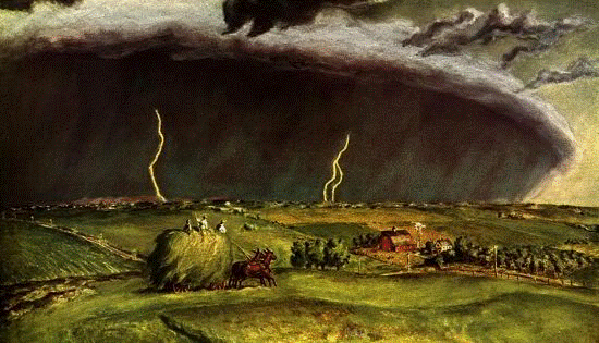
"The Line Storm," by John Steuart Curry, 1897-1946. (Image from NOAA)
I should have known that many SearchResearch readers would
know about derechos. I’m impressed that there are so many
searchers living in Maryland and places affected by the storm.
Short answers: This particular big storm was a derecho, first published in 1878, Iowa
Weather Bulletin Volume 1 Number 1, Dr. Gustavus Hinrichs, Iowa City, Iowa 1878.
When I did the search, I started with:
[2012 Maryland wind storm]
The first hit was a Wikipedia article on the June 2012 wind
storm in Maryland. http://en.wikipedia.org/wiki/June_2012_North_American_derecho
I quickly learned this kind of wind storm is called a
'derecho' which is a fast-moving linear storm system with extremely high
winds. Unlike a tornado or hurricane, it
doesn’t rotate, but flows rapidly eastward causing damage as it goes.
I looked up “derecho”
in Wikipedia and found a nice summary article there about derechos in
general. To double check my work, it was
simple to search for
CAPTION: Warnings
from the NWS on June 29–30. Red are tornado warnings, yellow are severe
thunderstorm warnings, green are flash flood warnings, and purple are special
marine warnings.
In the Wikipedia article I found that derechos are seen as
long linear clouds, “shelf clouds,” that show the advancing front.
Shelf cloud image from Wikimedia
Derecho comes from the Spanish word in adjective or adverb
forms for "straight" (adv, adj. "direct"), in contrast with
a tornado which is a "twisted" wind.
Wikipedia tells us that the term was first used in the American Meteorological Journal in 1888
by Gustavus Detlef Hinrichs when describing the phenomenon of a derecho that
crossed Iowa in July, 1877.
Several people went to Google Books, and did a search
for
["The American Meteorology Journal" ]
and limiting their search to 1888. It’s simple to find the book, search inside
the book for the term “derecho” and find it on page 307. This is a great approach, and often works for archival research papers like this.
In that article he mentions an earlier publication, in the
“Special Bulletin, No. 1, a quarto sheet, printed in two colors, map red, storm
details in black—by use of the electric pen.”
Curious about this, I looked up the Wikipedia article about Gustavus Hinrichs and discovered that he was actually
a chemist, best known for his discoveries about periodic laws in the
relationships between elements.This
work was important in leading up to the Periodic Table of Elements (although he
didn’t do the work of Mendelev—Hinrichs’ periodic table was in the shape of a
spiral).
But he had a longstanding interest in weather, and was also the founder of the first state
weather and crop service while a professor at University of Iowa.
Hinrichs' house in Iowa City (image from NOAA
Hinrichs’ first weather station was at his home in Iowa City
at the corner of Capitol and Market streets.
Flags on top of his house were barometer readings, and thought of as
weather predictions by the locals.
The Wikipedia article led me to an article at NOAA (the
government weather service). And the
NOAA article also has a link to a PDF of his report from 1878… What's odd about that report is that it looks like it's a handwritten document. So then how was it distributed? This was well before photocopiers, and while it's possible he wrote it out as an engraving, it would have been really hard to do so.
So how was it made?
Later in NOAA site it mentions that the original
publication done by electric pen, an Edison invention.
The “electric pen” was a device like tattoo needle, moving
up and down rapidly to punch a series of tiny in common writing paper. (See: http://electricpen.org/ ) This sheet of paper
produced a stencil which could then be used to up to 5000 copies from a single
original sheet. (That explains why the
PDF looks like it was handwritten. This
puzzled me until I read about the electric pen device.)
Fun side note: Did
anyone else notice the “Symbols and definitions” section at the beginning of
the paper? I was surprised to see “Hydro-meteors” (rain, snow, sleet…) and
“Electro-Meteors” (northern lights,
lightning, thunder…) and “Optical Meteors”
(shooting star, meteor, fireball, Zodiacal light…) as three separate
categories. Does anyone know why these
were broken out in this way?
From the original electric pen doc. (PDF from NOAA, see above.)
Search Lessons: This challenge was successfully solved by
lots of searchers—well done! The key
here was to pull together information from a number of different sources
(looking up the wind storm date to learn it’s a “derecho,” then looking up
derecho to find the publication, then reading that to find it to find out there
was an earlier publication). This is a
great skill to develop, especially in younger searchers, who tend to stop short
of double-checking their findings.