On being a tracker of information...

I went for a run recently, and ran across the following set of mysterious tracks in the trail.
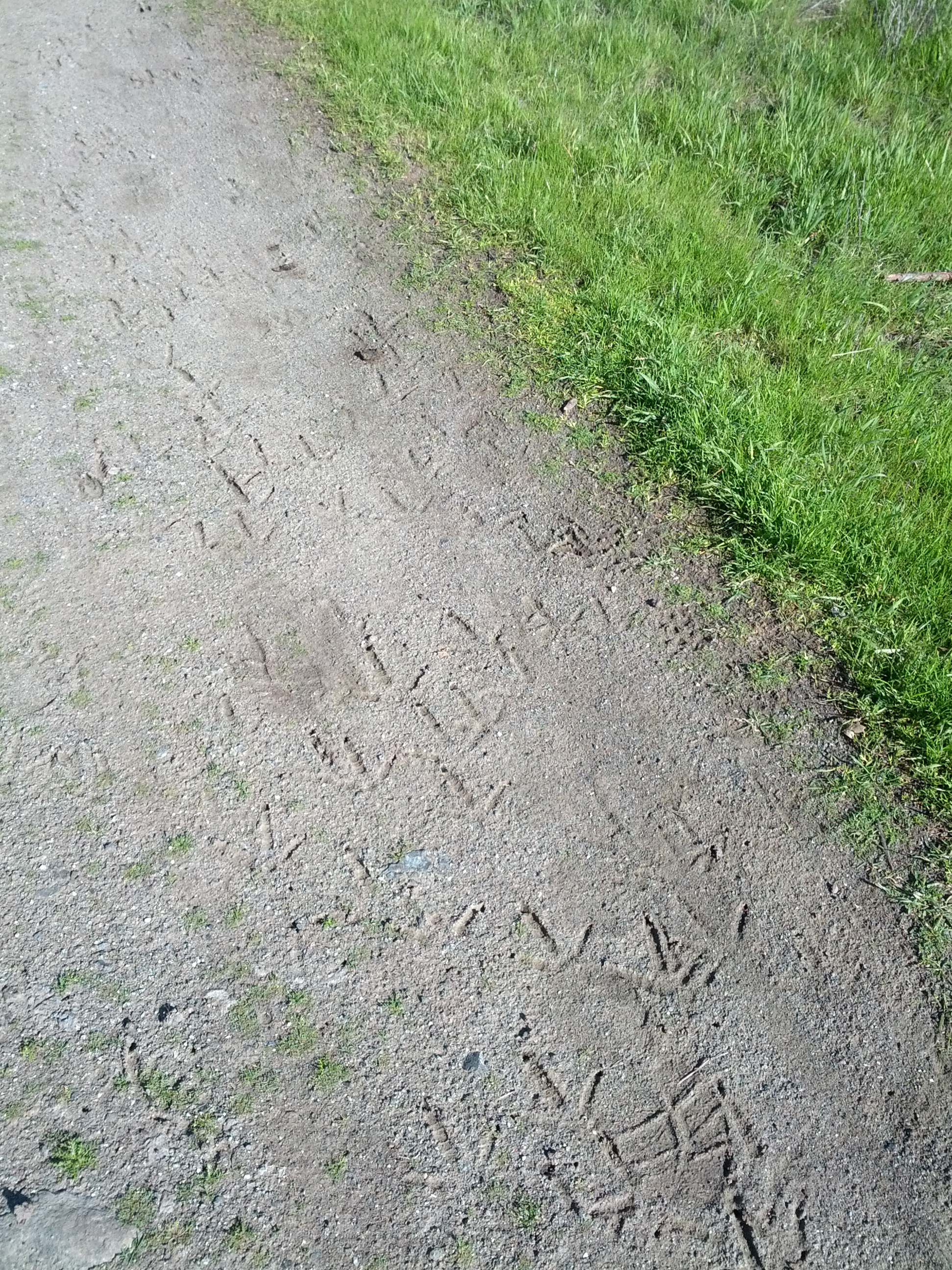
This is a unretouched image, just as I took it.
Today's question is very simple (but if you don't know how to solve it, it's probably close to impossible).
1. Exactly where and when was this photograph taken?
2. What kind of animal left these tracks?
(Ignore my shoeprint in the lower right. That's mine.)
(Ignore my shoeprint in the lower right. That's mine.)
As usual, be sure to tell us HOW you figured this one out, and let us know about how long it took you to figure it out.
(Trust me, there's enough information for you to figure all of this out. Remember, omnia iusta sunt in amore quarenteque omnes pulchrum est in amore et in quaerendo. ) { NB: Correction of my Latin text with regards to Marian. Thanks. }
Search on!
The picture was taken on February 20th, 2013 on the Fortini trail in Santa Teresa County Park.
ReplyDeleteI guess the track is from a wild turkey.
For the search, I first downloaded the file on my computer and read the exif data in Preview (on a Mac), I got the date and the GPS position. Just clicking on the "Localize" button opened Google Maps on the Fortini trail.
I the did some random search on bird tracks and quickly found it could be one of a wild turkey. I then searched [wild turkey santa teresa county] and found many photographs on Flickr of these birds in the park.
Searched "image metadata viewer" and found Jeffrey's Exif viewer (regex.info/exif.cgi)to find out date stamp and location coordinates from the posted image. From this,learned that the image was taken on 2/20/2013 in Santa Teresa County Park. Looked for a park map and narrowed down location to the Mine Trail.
ReplyDeleteAnimal tracks were harder--judging from accounts from sites that discuss wildlife in the park, the tracks may be from wild turkeys--which are known to roam in the park. Looking at image search for wild turkey tracks yields images that most closely match those on the posted image. I really hoped to find a good tool to break down animal track identification, but didn't find it.
1). Fortini Trail, San Jose CA.
ReplyDelete2) Turkey Vulture
Anne and I worked on this together. We started with question 1. We had no idea how to find the location so we did a simple google search using the query and got a number of results. We went to the second result which was answers.yahoo.com and we were directed to We went to that site and plugged in the url for your picture. That gave us the latitute and longitude (37.207815, -121.796929) for the picture. We took that informaiton and plugged it into google maps and very quickly got the anwer that this picture was taken at Fortini Trail in Santa Teresa County Park, San Jose. We were sure these prints were from a bird so we searched and got numerous results. We went to the first hit which was http://birdwalker.com/locations/459 Which listed the birds that have been sited on the trail. We knew that it had to be a fairly large bird because of the size of the talons compared to your footprint. We narrowed down the list and searched the birds we felt were possibilities. We looked at the turkey vulture first. We read the wikipedia article on this bird and thought it was a strong possibility. THen we did a search in google images for turkey vulture footprints and in the second row of images was a picture with a footprint that was exactly the same as in your picture. Reading the background of the bird with its size and habits it matched the criteria. We then looked at information for some of the other larger birds and none of them matched up. The first part of the problem took us about 2 mins. to solve. The second question took a little longer about 10 mins.
I saved the image to my computer and enlarged it to get a better view.
ReplyDeleteI used image search and Googled bird tracks. An image came up that looked like this one and I visited the page http://www.biokids.umich.edu/images/signs/tracks/gulltracks.jpg that told me these were gull tracks.
Next I looked at the address for your image, which told me it was taken on February 20, 2013
I then searched for Mountain View sandy trails and came upon the site for Steven’s Creek, but I noticed that they referred to them as dirt trails. So I used Control F to look at those.
I am guessing that this Shoreline Trail is the one you were on.
The dirt trail continues on along the shore of the salt pond below the paved trail.
http://baytrail.abag.ca.gov/vtour/map3/access/Btmtnvw/SltPndTr.JPG
There is a caution to use the paved trail to avoid disturbing nesting birds, so I assume that they could have been walking on this trail.
Began with a search for [ exif data location ] thinking since you told us it was an untouched photo that the exif data would still be there.
ReplyDeleteFound Jeffrey's Exif Viewer and pasted the url of your image in and saw that you were on the Fortini Trail
Latitude/longitude: 37° 12' 28.1" North, 121° 47' 48.9" West
( 37.207815, -121.796929 )
I then did a search for [ identify animal tracks ] and found the OC Trackers site http://www.octrackers.com/ Looked around and found http://www.octrackers.com/birdtracks.htm to say that the tracks are those of a game bird.
Did a search for [ "fortini trail" ] and found http://birdwalker.com/locations/459
So for kind of animal I'll say game bird since you didn't really ask for more specific than that.
02/20/2013 at 14:44
ReplyDeleteTurkey
The name of the image file.
ok, it should be a pheasant, right?
ReplyDeletei searched for [animal track like an arrow which kind], found that it should be an upland bird, and chose the pheasant for its dimensions in comparison with your foot track
Searched [how to find location and date information from photograph] which led me to "Jeffrey's Exif Viewer" at http://regex.info/exif.cgi
ReplyDeletePutting in the address of the photograph gave me the information regard when, where and how the photo was taken: http://regex.info/exif.cgi?imgurl=http%3A%2F%2Fdmrussell.net%2Fimages%2FIMG_20130220_144409.jpg
Using the geo coordinates shows the photo was taken at Santa Teresa County Park and a search for [Santa Teresa County Park wildlife] led to http://www.stpfriends.org/Santateresapark/stcpwild.htm which showed wild turkeys a s common.
A quick search on Google images for [Wild Turkey Tracks] confirmed.
Information such as geolocation can be found embedded in the picture itself (Exif standard, used by cameras and many smartphones). To retrieve such information, many tools can be used, like the identify command from the ImageMagick software suite. One easier way however is to upload the picture to Google+ and click on "photo details". A embedded Google maps shows a marker to the exact location, which is in Santa Teresa County Park, Ca. The first link to the results from the query "Santa Teresa County Park" points to a website containing all there is to know about this park, including it's wildlife. According to this website, wild turkeys can be seen in this place. A quick search for "wild turkeys footprints" in Google image shows me trails similar to the ones on the original picture.
ReplyDelete1. Exactly where and when was this photograph taken? I opened your image in Picasa and read the properties. This pic was taken at GPS Latitude 37 12\'28.1" N by GPS Longitude 121 47\'48.9 W. But Picasa messed up when I wanted to find the location in Maps. I used the GPS converter tool at Boulter.com see that the numbers should read 37.12281,-121.47489. When this went into Maps I found you on the Gilroy Hot Springs road. The 'When" is 20 Feb 2013 at 2:44:09 PM. This I know because I opened your pix in Picasa and read the properties. Time taken: about 30 seconds but 5 minutes to discover what was wrong with the Picasa numbers and convert and punch into Maps.
ReplyDelete2. What kind of animal left these tracks? The animal that left the tracks is a Gull. This I know because I have seen lots of their marks in the sand here. But I asked Search for [gull footprints] and got lots of images. You left a shoe print which I estimate to 1 foot long. This makes the bird prints about 3-4 inches long. Just right. And gulls are found right across North America. Goose is somewhat similar but there would be droppings all over the place. http://kids.britannica.com shows gull prints as do lots of other sites. Another 30 seconds.
Another good run. Thanks
Jon
First question was rather easy, according to the Exif-Data of the picture it was taken at 37° 12' 28.13"N, 121° 47' 48.94"W (Fortini Trail, San Jose) at 2013:02:20 14:44:09. Starting Meta-Editor (my favorite Exif-Viewer/Editor) and loading the photo took about 30 seconds.
ReplyDeleteSecond question was a bit harder. It looks like a bird track, so I searched for [bird tracks bay area], wich leads me to a nice overview at http://infothread.org/Animals/Bird%20Tracks.jpg
It looks exactly like a killdeer-track, so I just checked if killdeer is a common bird in the bay area with seraching [birds common bay area], which leads to http://www.sfbaywildlife.info/species/common_birds.htm an voila there is our Killdeer in all its beauty.
Took about 10 minutes or so
The picture was taken on 2/20/2013 2:44:09 pm on Fortini Trail in Santa Teresa County Park. Coordinates 37.207815, -121.796929. From the photo's exif data.
ReplyDeleteI believe they are wild turkey tracks. I searched for birds in Santa Teresa County Park and the site for the friends of the park and there was a picture of a group of wild turkeys. I searched for wild turkey tracks and they looked like what was in your photo. I ruled out birds of prey like hawks or turkey vultures because it looked like the tracks were from a group of birds not a solitary bird foraging for food as hawks or turkey vultures are known to do. Anyways, that's my guess.
The first part was quick the second part took me about 10 minutes because I was not very efficient with my searching.
Here's my take on it:
ReplyDeleteLocation: Santa Teresa County Park - https://maps.google.com/?ll=37.207815000000004,-121.79692888888889&q=TEMP@37.207815000000004,-121.79692888888889
Date: 02/20/2013 at 2:44:09PM
Animal: Turkey! Judging from http://www.stpfriends.org/Santateresapark/stcpwild.htm and the footprint of a turkey matches the one in the picture
According to the exif data, the photo was taken at 2:44:09 on February 20, 2013 at coordinates: 37.207815 degrees N, 121.796929 degrees W.
ReplyDeleteA search of the location reveals that it is in Santa Teresa County Park. A search of wildlife at the park shows that it contains wild turkeys, which is what made the tracks.
Clues:
ReplyDeleteImage. Mountain View. Triangle, pebbly texture
rock light
search
[animal tracks]
To find: http://www.bear-tracker.com/guide.html. There I read and found: http://www.bear-tracker.com/turkey.html and "It is hard to see unless you find the track in good mud or fine soil"
In maps searched Googleplex and looked for "trail" and images similar.
[wild turkey "permanente creek trail"]
to find: http://groups.yahoo.com/group/lbox-announce/message/24324. "Cross the bridge over Permanente Creek and take the Permanente Creek Trail to
the far right. This trail passes between the creek and a large meadow. A large
flock of wild turkeys sometimes hangs out here."
For the when, tried with the sun reflection on the stone and found nothing. Then looked properties in the image.
1. Exactly where and when was this photograph taken?
A. Where: Permanente Creek Trail. When: 2:44 pm
2. What kind of animal left these tracks?
A: Wild Turkey
Uh, I was going to say ancient theropods in Argentine (http://www.newscientist.com/article/dn2466-ancient-birdlike-footprints-found.html), then I read the rest of your post and the fact that your footprint is mixed in with it rules that one out :-(. Those prints are millions of years old and in stone.
ReplyDeleteThe photo was taken on 20-Feb-2013 at 14:44_09.
ReplyDeleteAt 37° 12′ 28.13″ N, 121° 47′ 48.94″ W
http://toolserver.org/~geohack/geohack.php?language=en¶ms=37_12_28.13_N_121_47_48.94_W
This info can be found in the EXIF Info of the original image. Any good image viewer will show this information. I used Irfanview.
KV
Mumbai, India
If the image properties are correct (saved to Windows 7 desktop > right click > properties > details) the photograph was taken on 2013/02/20 at 02:44PM with a Samsung Galaxy Nexus (still quite happy with my own GN mind you.
ReplyDeleteLatitude: 37; 12; 28.13399999999092
Longtitude: 121; 47; 48.944000000017...
Altitude: 96 (feet?)
Ok, I'm not sure how much time we're given for this, so I'll post this so long and get on the rest.
Ok so now you are getting tricky.
ReplyDeleteWe know from past experience that you like to run at Stevens Creek Trail, Mountain View, CA in the morning. The tracks look like bird tracks to me, in fact they look like Quail tracks. Or more exactly they look like the tracks of the California Valley Quail, the State Bird of California.
From http://www.bear-tracker.com/quail.html
But they also look like some shore birds so need check.
From http://www.wildernesscollege.com/bird-tracks.html
It looks like the tracks are
“Anisodactyl Tracks
These "classic bird tracks" are made by birds with feet that are anisodactyl, which is defined by a foot in which 3 toes are pointed forward and 1 is pointed backward.”
And looking closer it might be that they are (from same wilderness web site):
“Game Bird Tracks
This type of foot structure, sometimes called “incumbent,” leave what is commonly called “game bird track” pattern. In this grouping, the toe 1 (also called the halix) is greatly reduced or even absent.”
This includes Quail.
Lets check and see if quail are found near where you might be running.
Looking at three different sites they all say that the Callipepla californica, California Quail live from Washington all the way down through Southern California.
http://en.wikipedia.org/wiki/California_Quail
http://www.shadyhollowfarm.com/valleyquail.html
http://www.nhptv.org/natureworks/californiaquail.htm#6
But this does not feel right.
There is something about this picture that should tell me everything, and I am looking hard at the picture.
Lets look at your Latin term - omnes pulchrum est in amore et in quaerendo
Google Translate says “All is fair in love and trying to find the”
Well that helps. Not.
I think that they may have been rained on a little bit so could check the weather for the area and see when it last rained. If it is a different bird then it could be that they are only in the area at certain times of the year, but . . .
I have to go do other things now, so I have to go with what I have. And I am not sure of any of it.
Tracks are of the California Valley Quail, the State Bird of California (Callipepla californica)
The picture was taken at the Stevens Creek Trail, Mountain View, CA in the morning.
Well now I feel like a fool. I thought for sure that you would not have left the EXIF data on the image so did not even look. Won't do that again.
DeleteStill think it is the State Bird. But what do I know.
Was fun though.
Ok, continuing from my previous post.
ReplyDeleteI had a really hard time to try and convert the exif GPS coordinates into something that Google Maps could use. Eventually, this search: http://goo.gl/sFJeA, lead me here: http://goo.gl/OqWoH (Jeffrey's Exif Viewer), where I entered the URL for the photograph in your blog. Amongst others it showed a map with the coordinates formatted differently: 37° 12' 28"N, 121° 47' 49"W
I copied and pasted that into Google Maps and got the following: http://goo.gl/maps/pB9LX, indicating that you were on the Fortini Trail. Zooming out I established that the Trail in San Jose - California. ...and near the IBM Almaden Research Centre :-)
No for what kind of animal left these tracks? Looks like a bird, but let me look into it...
where & when:
ReplyDeleteSanta Teresa State Park
Date Time 2013:02:20 14:44:09
Make Samsung
Model Galaxy Nexus
guessing turkey tracks based on a park/trail user sighting:
(could be IBMer tracks from Almaden?) ;)
f-search "turkey"
how: downloaded image & got EXIF info for where, when, with what. Went to Google maps with the L&L coordinates.
searched sites for bird track ID info - overwhelmed, but thought turkey was possible - then searched Santa Teresa Park with turkey included and found a sighting... then guessed. The location was relatively quick, spent longer on the bird tracks, ~ 20 minutes total. Look forward to how to derive the track source from your photo - hope you aren't going to say it was a woodpecker.
NB... paulo academia ambitiosior
Deletestill not getting the latin ref & GooTrans really isn't getting it either - even with the correction.
am curious where Sasser saw "turkey" as the image file name... and with Passager, does Preview open in GooMaps by default instead of maps? or is that a preference you set?
a turkey by any other name... I mean une dinde sous un autre nom...
stpfriends
Sorry, but I must correct your Latin. Here's what you said "all things is beautiful (singular) in love and about to be sought."
ReplyDeleteHere's what you probably wanted to say:
"omnia iusta sunt in amore quarenteque" (or "et in quarente")
I was hoping someone would correct it! Thanks, Marian!
DeleteYou're very welcome. Bet you didn't know you had a Latin teacher among your fans.
DeleteOk, following on my other comments about where and when, now the what. Jeez, this was a struggle. I searched for a long time using the name of the park and stuff like "animal tracks", "identifying animal tracks", etc. No luck. At some point I decided to rather focus on San Jose and then got warmer, but still suffered. Eventually this search (http://goo.gl/kbNjD):
ReplyDelete"San Jose" "animal tracks" online guide
...lead me to http://www.bear-tracker.com/guide.html and comparing their track sketches to your photograph I decided on the California Quail. I followed the hyperlink to their page on the California Quail (http://www.bear-tracker.com/quail.html) and noticing that it is the state bird of California I'm hopeful that I've now nailed it. Holding thumbs...
Took about 5 minutes
ReplyDelete1) After saving your picture I looked at the details in properties of the files and saw that you took this with your phone at 2:44 on the 20th. It also says the location was +37.78, -121.50 which I'm guessing you were somewhere in Coe State Park.
2) The tracks look more bird than mammal and the one above your boot print is the clearest. Based on the number of prints and being a solid arc at the bottom, I would say it was a turkey vulture.
Oh, I forgot the 'how long' it took me. I'm not sure, probably about 75 minutes. I got a little stuck :-)
ReplyDeleteThe easy part, when and where, using the exif data:
ReplyDeleteDate: 2/20/2013
Time: 14:44
Lat: 37.207814
Long: -121.79692
With google maps i find (at that location)
Fortini Trail, Santa Teresa County Park, near San José California
Search in Google by [Fortini Trail]
Santa Teresa County Park Trails
http://www.stpfriends.org/Santateresapark/stcptrl2.htm#Fortini
From the information in that page:
"Web pages on the wildlife habitats in the area"
http://www.almaden.ibm.com/almaden/almaden/environs/
From there, get the wildlife information and search for footprints
The winner was [california quail footprints]
Compare images and (a little) trust in my judgement comparing footprints.
Animal: california quail
Total 10 minutes (including some chat with my wife about how she can print to my local printer from her office)
From the EXIF information of the picture (the metadata) I got the following facts:
ReplyDeleteWhen was this photograph taken: DateTime - 2013:02:20 14:44:09
Where was this photograph taken: GPSLatitude - 37 12 28.13 (37.207814) / GPSLongitude - 121 47 48.94 (121.796928)
This is at the Fortini Trail in the Santa Teresa County Park.
A search on ["Fortini Trail" wildlife] brought me to: http://www.stpfriends.org/Santateresapark/stcptrl2.htm#Fortini and from there to: http://www.almaden.ibm.com/almaden/almaden/environs/ and http://www.stpfriends.org/Santateresapark/stcpwild.htm
I suppose the footprints are from the California Valley Quail (Callipepla californica) :http://www.bear-tracker.com/quail.html
Aprox.: 15 minutes
all is fair in love and in trying to find the (latin translation Google Translate) not a clue however
ReplyDeleteWhat do I know.
Dan runs near his office. Looks like a grassy area. Distinct path, soft gravel. Strange markings
Image taken in late winter early spring, sunny day, dry conditions
Questions
Any metadata (thanks for teaching me about this) Ran it through goggles and exif
Question 1
Fortini Trail
Feb 20 2013 14:44
037.207815 -121.796929
Time 30 seconds
Beautiful running area.
Question 2
Query [fortini trail building maintenance]
Trail making crew with trail compress machine -
http://www.stpfriends.org/Fortini_05-03-08/Fortini.html
I don't have confirmation, this is a hunch. Will get back later
Question Two
ReplyDeleteWhoa. I think I was way off. My final answer is supported by two sources
http://www.wildwoodtracking.com/birds/geese/index.html
And
http://www.flickr.com/photos/pfsullivan_1056/6818384757/
My final answer Canada Geese footprints.
What did I learn.
First opportunity to use image metadata. Really cool.
I did stop my search and changed direction. I had to reconsider that maybe an animal or bird was capable of making the markings.
As a hiker and trail runner I was familiar with trail grooming and went with it first. Be openminded.
1. Where and when?
ReplyDeleteI googled [exif data viewer] to find . The data tells me the picture was taken on 2013-02-20 at 2:44:09 P.M.
It also indicates GPS Position 37.207815 N, 121.796929 W. I head over to Google Maps and copy that. The picture was taken on the Fortini Trail in the Santa Teresa County Park.
- 1 min. -
2. What bird?
That one was a little harder. I started by looking closely at the picture. I noticed a few things:
- I estimated your shoeprint to be about 4.5" across. The bird tracks seem to be half of that, about 2.25".
- The tracks show 3 toes in the shape of an arrow with no webbing.
Knowing this, I googled [identify bird tracks], and found . I narrowed it down to California Quail, Wild Turkey, and Turkey Vulture, as they were the three that were not webbed and had 3 toes. Track size for quails is about 1.5" (beartrack), 3.5 to 4.5" for wild turkey (beartrack), and 3.75 to 5.5" for Turkey Vulture (Wikipedia). There's a nice pic showing both turkey and quail track together
Final answer: Either a young wild turkey or a young turkey vulture.
- 20 min -
I tried to break through using my social network. I upload the picture no Google+ and click on "photo details". A embedded Google maps shows a marker to the exact location, which is in Santa Teresa County Park, Canada. Then i search "Santa Teresa County Park" the top link from the results points to a this website containing all there is to know about this park, including it's wildlife http://www.sccgov.org/sites/parks/Ride%20Here/Pages/Santa-Teresa-County-Park.aspx According to this website, wild turkeys can be seen in this place. A quick search for "wild turkeys footprints" in Google image shows me trails similar to the ones on the original picture.
ReplyDeleteImage properties to get location
ReplyDeleteEnter coords into google earth
Google park name and find out about the wildlife there
Wild Turkey looked promising so googled wild turkey footprint and got a match
Feb 20 2013 at 2:44pm
ReplyDeleteLocation is GPS: 37.207815000000004,-121.79692888888889 = alongside the Fortini Trail in the Santa Teresa County Park, CA
Bird: Wild Turkey
Downloaded image to computer and consulted image information to get time and date.
Found the GPS coordinates but couldn’t figure out how to enter them into Google Earth so I uploaded to Picasa and enabled location data which showed the location.
Did Google Search for bird footprint identification and found Orange County Trackers webpage: http://www.octrackers.com/birdtracks.htm . Prints seemed to match a game bird but couldn’t tell which one from there so found Nature Tracking’s bird print ID page: http://www.naturetracking.com/Tracking/Bird_Tracks.html#grid that has turkey prints that seem to match the picture.
Did a search for Santa Teresa County Park and looked for a page with information about birds in the park to see if turkey are present and/or common.
According to Bay Area Hiker (http://www.bahiker.com/southbayhikes/santateresa.html) turkey are present in Santa Teresa so that’s the bird I’m going with.
It probably took me about 30 minutes to figure this out.
Hi, i did similar search for [image metadata viewer] and found Jeffrey's Exif viewer. I opened your picture in a separate link and typed that url in the searcher. It gave me lots of information with latitude and logitude. I used this information on the google maps and reach to Fortini Trail in CA.
ReplyDeleteI then googled [animal tracks] but didn't find exactly what i was looking for, so i tried arrow shaped tracks and i found this tracks were from birds, mentioning wild turkeys and pheasants.
I did an additional search for [fortini trail birds] which led me to the page http://birdwalker.com/locations/459 where names 17 species of birds, including turkey vulture and wild turkey. I didn't have much more time to dig around measurements of the 2 types of birds,so it could be one of those.
I then googled [animal tracks] but didn't find exactly what i was looking for, so i tried arrow shaped tracks and i found this tracks were from birds, mentioning wild turkeys and pheasants.
ReplyDeleteI did an additional search for [fortini trail birds] which led me to the page http://birdwalker.com/locations/459 where names 17 species of birds, including turkey vulture and wild turkey.
mysql services