I was at the sea the other day...
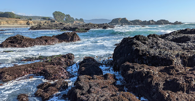 |
| The tide comes in near Gualala, California. P/C Dan. |
As usual, I had looked up the tides before going, so I'd know when both high and low tide were to happen. That's an easy query on Google. If you do:
[ tide chart ]
Google will return a list of local tide chart sites, like this (my query here was done from Palo Alto, CA):
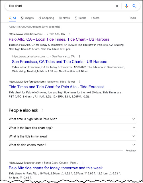
And if you click on the first result, you'll see a beautiful chart of the tides near you:
 |
| Chart from USAHarbors.com |
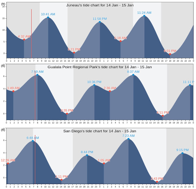
As it happens, the other day when I went for my seaside walk, I was near Gualala, California, and I'd looked up the tide chart, which looked like this:
 |
| All charts in this style are from TidesChart.com |
On Jan 14, the first low tide was at 1:49AM while the first high tide was at 7:59AM; second low tide was 2:35PM and second high tide at 10:36PM.
In one of those serendipitous moments that defines SearchResearch, I just HAPPENED to have looked up the tide chart for San Diego earlier that morning (I was looking up something else, don't you know...). So when I saw this chart for Gualala, it struck me that the time of the tides were different!
As I've often said, noticing small inconsistencies in the world often leads to curious outcomes. This is one of those.
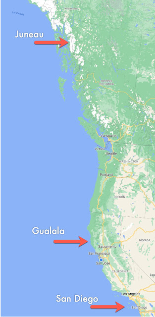
Here's the tides chart for three locations on the coast of North America, San Diego (just above Mexico), Gualala (one quarter of the distance to Alaska), and Juneau, Alaska (way up north). See the map down below.
That's when I noticed--for the first time--that the tides seem to arrive later and later the farther north you go. To see this, look at the first high tide peaks: San Diego at 6:48AM, Gualala at 7:59AM, Juneau at 10:41AM. Apparently, the tides seem to arrive about four hours later. The distance, as the jet plane flies, is about 1947 miles (3134 kilometers) between San Diego and Juneau, so it seems the "tide" apparently travels at around 486 mph from south to north (787 kph).)
Realizing that the tides don't all go up/down at the same time along the west coast of North America was a surprise. I'd implicitly assumed that they all went up and down at the same time. (A moment's reflection makes me realize that can't possibly be true.)
BUT... it leads to today's SRS Challenge:
1. Is there some way to understand how the tides move around on the planet? If the time of high tide varies so much on the west coast of North America, there must be a similar variability in low tides at different locations. Is there some way to understand how tides vary over the course of a day? What's the best way to get an understanding of this global behavior?
When I did this Challenge, I was happily surprised to find that there are some beautiful ways to understand this. Perhaps you can find them as well? (I guarantee that this is an easier problem that the Skytree shadow!)
Let us know what you found to answer this Challenge and HOW you found it!
Search on!
Wow... this wasn't difficult but it was fascinating.
ReplyDeleteMy first search was for and this quickly told me things were much more complex. The distance of the moon from the Earth is important but the sun also plays a part. Another factor is the coastline topography and the latitude. So I added latitude to my search too.
One site that went into a lot of detail gave a definition that had nothing to do with the Earth's rotation: "A tide is a distortion in the shape of one body induced by the gravitational pull of another nearby object." This gave a lot of the Math and theory of tides. https://www.lockhaven.edu/~dsimanek/scenario/tides.htm and this also states: "The oceans don't cover the entire earth, but "slosh around" daily within the confines of their shores. Timing of the ocean tidal bulges even at mid-ocean can depart considerably from the idealized tides we have described. Reflections from shores can set up interference patterns farther out in the ocean. Coastal tides have considerable local variations due to difference of shoreline slope, and ocean currents."
The UK Tide Times site (https://www.tidetimes.co.uk/news/tidal-variation-in-the-uk/) states: "The specific features of a coastal location can affect how water moves, creating a lag that influences the times of the tide and other conditions. These variations give each coastal location a unique tidal pattern." Another site saying the same sort of thing is https://ntslf.org/about-tides/tides
The National Ocean Service has some explanations at https://oceanservice.noaa.gov/education/tutorial_tides/tides08_othereffects.html
An answer on Quora states "Because the simple explanation of tides is partly wrong. The Moon and, to a lesser extent, the Sun are certainly the driving mechanisms. But what they drive is a resonance that also depends on water depth, shape of coastline, and a host of other things." https://www.quora.com/Why-do-tide-times-vary-in-different-locations/answer/Paul-Camp-3 - this page includes a great video which shows how tides vary depending on the geography.
There's also videos of the Bay of Fundy which has the highest tides in the world - at https://www.bayoffundy.com/about/highest-tides/
Much more theoretical is https://link.springer.com/article/10.1007/s40641-016-0044-8w which also says "changes in geometry (which alters resonance, wave speed, and other quantities) and in surface characteristics (i.e., changes in roughness which can alter damping)" can lead to tidal differences.
Interesting!
ReplyDeleteStarted with [today i found out tides]
What Causes Tides? NOAA
Moon. One cycle of tides actually takes 24 hours and 50 minutes. Site includes more tidal facts.
Scientific American (1858)
*The difference in the hight of tho tides at various places is due to the peculiar formation of sea coasts
https://www.scientificamerican.com/article/the-tides-1858-01-23/
https://scijinks.gov/tides/
With [ tide speed]
World-class swimmer travels at a sprint speed of around 4 knots, while dolphins cruise at 6-7 knots.
[tide difference latitude]
Tidal ranges and tidal-current speeds increase as the tidal wave propagates onto and across continental shelves.
https://pubs.geoscienceworld.org/books/book/2163/chapter/125273302/ARE-TIDES-CONTROLLED-BY-LATITUDE
In YouTube, Explaining the tides in the world.
https://youtu.be/3RdkXs8BibE
With [Tide Explanation] found the site. And next to tide article, came this.
DeleteSea or Ocean?
https://www.oceanclock.com/en/blog/32-what-is-the-difference-between-sea-and-ocean
Also, among others, they have an article called: how to read tide times ?
Out of topic. However, I think Dr. Russell and maybe someone else will find it interesting.
DeleteFrance in Puebla. Includes Google Maps 360
https://www.eluniversalpuebla.com.mx/que-hacer/pasaje-frances-la-historia-del-callejon-de-los-vitrales-en-el-centro-historico-de-puebla
And a second building,apparently, with Eiffel Tower roots
https://www.google.com/amp/s/amp.milenio.com/estados/edificio-frances-centro-puebla-historia-construccion
On the west coast of North America the returning tide is forced by the Coriolis effect of Earth's rotation to be pushed to the right--landward-- as it races from the equatorial region at 700 mph to the north. This is why the shift change is progressively later. The time for tidal effects are determined by actual tide recorders at major ports. The ?Gladulala times are calculated, it not being a major port.
ReplyDeleteI used my old book 'Oceanography of British Columbia' which has beautiful drawing of the tidal 'wave' moving northwards.
You are correct Sir, this is way more easier [and understandable] than the shadow problem.
under the surface…
ReplyDeletebelow the changing tides, to the changing coral… unusually deep?
future dive?
image
Laetitia Hédouin - is there audio translate from video?
her twitter
pics on the coral - good images/vid
fwiw, thought the link Arthur Weiss provided to the Bay of Fundy was helpful in explaining the tide movement & times and some anomalies
ReplyDeletelike the Old Sow: (sRs always leads to unexpected info/unintended consequences/chaos/butterfly effect…)
old sow - Western Passage of the Passamaquoddy Bay
wiki fundy wheeee
the most endangered whale in the world
Eubalaena glacialis
when things are tideless:
Slack water - see the physical oceanography
for MathLady… related to tides? but I may be all wet
You know as much as I do about stability theory but differential equations are used to model things that move and change. I did find this one interesting paper:
Deletehttp://wakes.uma.pt/cimar/PartII_lecture1.pdf
The equations are formidable but the commentary and diagrams are helpful. The author states that ocean tides are caused by the horizontal gravitational force of the Moon and Sun, not the vertical force, which seems counterintuitive to me. The author also says: “A fact from physics: if a system is influenced by a periodic force, its reponse [sic] will also be periodic.” That seems obvious, but thinking about it helped me visualize tidal variations with respect to the movements of the Sun and Moon and the Earth’s rotation.
On another note, I heard something a few weeks ago that reminded me of this group. I was watching football and a player did something spectacular. The announcer quoted the player as having once said - I am not the fastest guy out there, or the biggest, but I take the time to understand things that most people do not understand. Secret of his success.
…wisdom from football, extracting the salient - good tip
DeleteNazare, Portugal
as you calculated, the numbers are beyond me, but that seems like big vertical water — gravitation tidal force vectors -
wonder if the same calcs work on Mars?
I'm perplexed just by the Starlink instructions - maybe being connected to the interwob isn't that important…
it makes the cranial chip hurt
"Why are waves so big in Portugal?
Nazaré is a very popular surfing destination because of the very high breaking waves thatform due to the presence of the underwater Nazaré Canyon. The canyon increases and converges the incoming ocean swell which, in conjunction with the local water current, dramatically enlarges wave heights."
how
Dec. 2021
isochronous curve
vectors on materials
barotropic model
Fun challenge to return to! It's been a while since I've been able to do one of these! Not that hard but very interesting. Had I thought about this would have realized that tides were not exactly the same in various locations along a coastline. I just assumed that everywhere on the NJ coast had the same high and low tides and if not exactly the same very close. Did a search for -why are tides so different around the world_ which led me to the National Tidal and Sea Level Facility at the Univ. of Liverpool. The site explained how tides particularly in the UK are different because of not just the pull of the moon and sun but also because of the elliptical circuit of the moon and then also the geography of the coastline and the depth of the water. Could have spent more time on this but work is calling me back! Nice to see some familiar names here and nice to see some new ones. I'll have to get Anne back involved in working on these searches. She is now at a different school so we are no longer working together.
ReplyDeleteQuery to a human being; Is that even allowed? I have a friend who used to develop tide books with a year’s worth of predictions for tides in a given location.
ReplyDeleteI asked her:
“How did you get the information for the tide books you made? How accurate are they a year ahead of time?”
Her response: “We got the info from NOAA. They have been collecting tidal data for a long time. As I understand it, the predictions are based on past data, as well as the position of the moon and sun. However, tides can be affected by weather and changes in atmospheric pressure. But I believe the predictions are pretty reliable a year or more in advance.”
(Interesting coincidence: She has/had a place at Gualala, CA.)
SRS is about finding information in ALL forms. "Call a friend" is definitely allowed.
DeleteI was mistakenly conflating waves & tides… checked the NOAA point from "ground truth" suggested by Mathlady & her friend
ReplyDeletetides v waves
smithsonian - gyres explained
NOAA - The Center for Operational Oceanographic Products and Services (CO-OPS)
extremes
from the map
station
inland
Good point. They are very different.
Deleteneed to find a 'Doc ' to sit on… hopefully it won't be named 'Anthony'.
ReplyDeleteon the left, even then, imho (still a good doc on balance)
San Fran, a great place to watch the tide roll in (Roll Tide)
the classic
tides and the Oakland bridge
Loved the "tides and the Oakland bridge" article. The image of the mariner touching the bridge as the ship passes beneath is remarkable.
DeleteWhen I looked at the US West Coast maps it did not occur to me that high and low tides in the various locations should be concurrent. Not only are they at different latitudes (where the velocity due to the Earth’s rotation varies) but different longitudes as well and if the tides move in an easterly direction….
ReplyDeleteThis seemed like a somewhat open ended challenge with many variables, unless we are limited to the three sites on the US West Coast.
According to NOAA there are three basic types of tidal patterns: semidiurnal (US East Coast); mixed semidiurnal (US West Coast); and diurnal (Gulf Coast).
https://oceanservice.noaa.gov/education/tutorial_tides/tides07_cycles.html
The diurnal is the least common of the three and is found on the shorelines of the Gulf of Mexico. According to http://classroom.sanibelseaschool.org/physical-properties-of-the-gulf-of-mexico
“Due to the abnormal shape of its basin, the Gulf of Mexico experiences irregular tidal cycles. The Gulf of Mexico shoreline sometimes experiences two low tides and two high tides every day, and sometimes it experiences only one high tide and one low tide in a day.” Interesting.
I chose three geographically separate locations to investigate: South Padre Island TX; Mobile AL; and Tampa FL.
This is the web site I used: https://www.usharbors.com/harbor/alabama/mobile-state-docks-al/tides/
Looking at tidal data over several months (which I will spare you), Mobile is diurnal most days but has two 2 – 3 day periods each month when it has two high and two low tides on each day.
South Padre and Tampa are the opposite, having two highs and two lows most days, with two 2 – 3 day periods each month when tides are diurnal.
These periods for the three data points are at roughly regular intervals, but do not seem to correspond to the phases of the moon or to each other.
I would like to find some pattern here myself; perhaps more data will help. Otherwise, I will apply my embryonic search skills and see if someone else has deciphered this.
I turned my attention to our old friend of Zanclean fame, the Mediterranean. I found an article from the Irish Astronomical Journal, vol. 6(1), p. 12 describing tides in the Mediterranean:
https://adsabs.harvard.edu/full/1963IrAJ....6...12M
This sea does have tides, small ones, as do its marginal seas such as the Black and Caspian and the Sea of Marmara. I selected four locations: Nice, Tel Aviv, Venice, and Tunis. I looked at current data for them.
I found this web site helpful. The representation of the data makes it easy to see what is going on.
https://www.tide-forecast.com/locations/Venezia-Italy/tides/latest
The tides at Nice and Tel Aviv are small, typically less than two feet. Tides at Tunis are mostly less than a foot. Tides in Venice sometimes exceed three feet. I imagine there are geographical reasons for these differences. That’s a topic for another day.
As Arthur said, fascinating.
Next stop: Antarctica.
We are definitely NOT limited to West Coast of NA tides!
DeleteAnd yes, the tides around Antarctica are fascinating (and not yet well understood).
Deletethe axis points… M, good luck with your quest south of 60°S latitude
ReplyDeletesouthern ocean, waves & tides video
saildrone tech
insta - the shot with the Golden Gate is nice
the GG
in the Arctic
article, the frozen tide
off subject, interesting topics
saildrone news
gulf stream
saildrone data sets
Findable, Accessible, Interoperable and Reusable (FAIR)
related quaking??
I find almost everything about Antarctica intriguing (Anthony Bourdain even did a show from there) but to the point of this challenge: The Southern Ocean circumnavigates the continent with no large land masses in the way; that ocean touches no other continent. I believe it is the only one with that behavior. Does this affect the tides? What about the monster storms they have there?
DeleteThis comment has been removed by the author.
Deleteit all feels so upside down for some reason
ReplyDeletelow tide - Port Lockroy
Goudier Island
low tide allows walking…
marinebio…
blog
is that a Rusty parrotfish?
Scarus ferrugineus
"Does it feel upside down on Antarctica? Of course not. Gravity pulls you down towards the centre of the earth that you are standing on. The thing that feels weird is the sun moves to the left in the sky whereas for those of us used to living in the northern hemisphere it always moves to the right."
ice hole
may be of interest to ML
ReplyDeleteadditional bits
"Tidal range (m), defined as maximum surface tide height minus minimum height over 1 year. Sites identified as 1–6 show locations for which the sea surface height amplitudes for the major tidal constituents are given in Table 1. (b) Mean tidal current (m s−1), defined as the annual average of instantaneous tidal speed, |u| = (u2 + v2)1/2, where uand v are east and north components of tidal velocity. (c) Tidal form factor,F = (amp(ζK1) + amp(ζO1))/(amp(ζM2) + amp(ζS2)), where amp(ζX) is the surface height amplitude of tidal constituent X. Small values of F indicate that tides are semidiurnal (two high and low waters per day); large values indicate tides are diurnal dominated, for example, in the Pacific sector along the Antarctic coast. Maps are on a Miller cylindrical projection to emphasize the polar regions."
I remember teaching about the amplitude and periodicity of waves but was curious about the relationship between the amplitude and the type of tide. This seems to imply that the amplitude of the waves influences the type of tidal pattern. I searched
Delete[tides that change from diurnal to semidiurnal]
And got mostly sites I had previously seen, but a few new ones which might prove to be illuminating.
three that might have something useful… (if you haven't already seen) – used [amplitude and periodicity do they infulence wave type pattern]
Deletewave behavior
Wave Properties
wave physics
you are probably familiar with WolframAlpha… I am to much a simpleton and to dive deep it takes PRO & $…
Deletewolfram
different search
others:
Wave Parameters
Khan
I am a borderline computational ascetic so I have been relying on non-digital resources for the equations, even though they lack CTRL F keys.
DeleteIf anyone is looking for a fun diversion, try looking up “tide” in the Oxford English Dictionary. The word has a long history and many literal and figurative uses and is a natural companion to time.
up north
ReplyDeletefrom Yandex [arctic tidal movement]
SERP
search needs audio coaxing…
ReplyDeletecourtesy of Snoop, Corona & the googley — Easy Street
ear bug
1975 - Africa - -34:55 Written-By -- Keith*
frazil crystals… is there a National Arid Center?
ReplyDeleteBoulder - far from a sea… for now