Once again, I'm impressed with the search savvy of the SearchResearch Irregulars! Nice job.
Obviously, I'm here, looking at these places in real time, but here's what I would have done, if I'd been somewhere else...
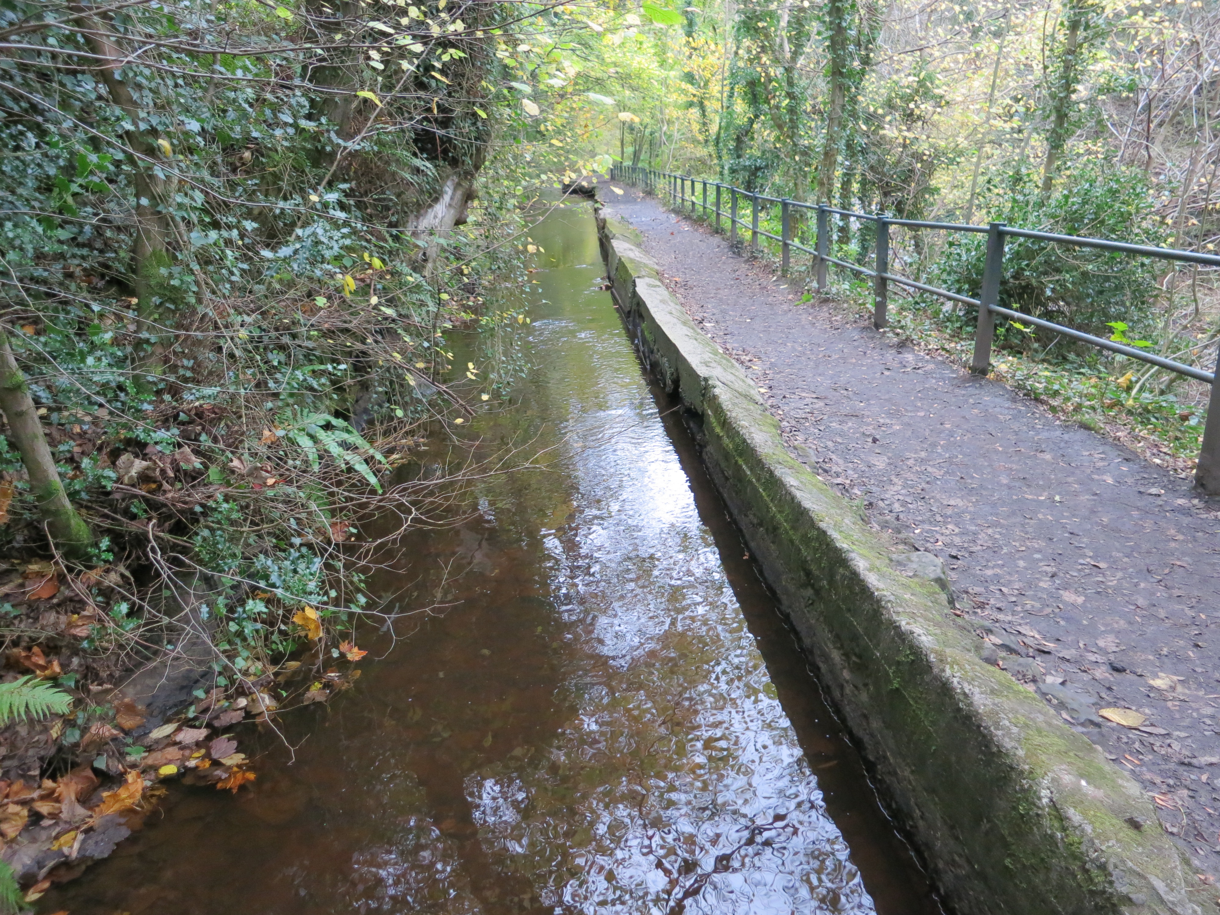
1. What is this strange obviously artificial waterway? Did it serve any particular function? If so, what?
I would have just dropped this coordinate into Google Maps; that shows this....


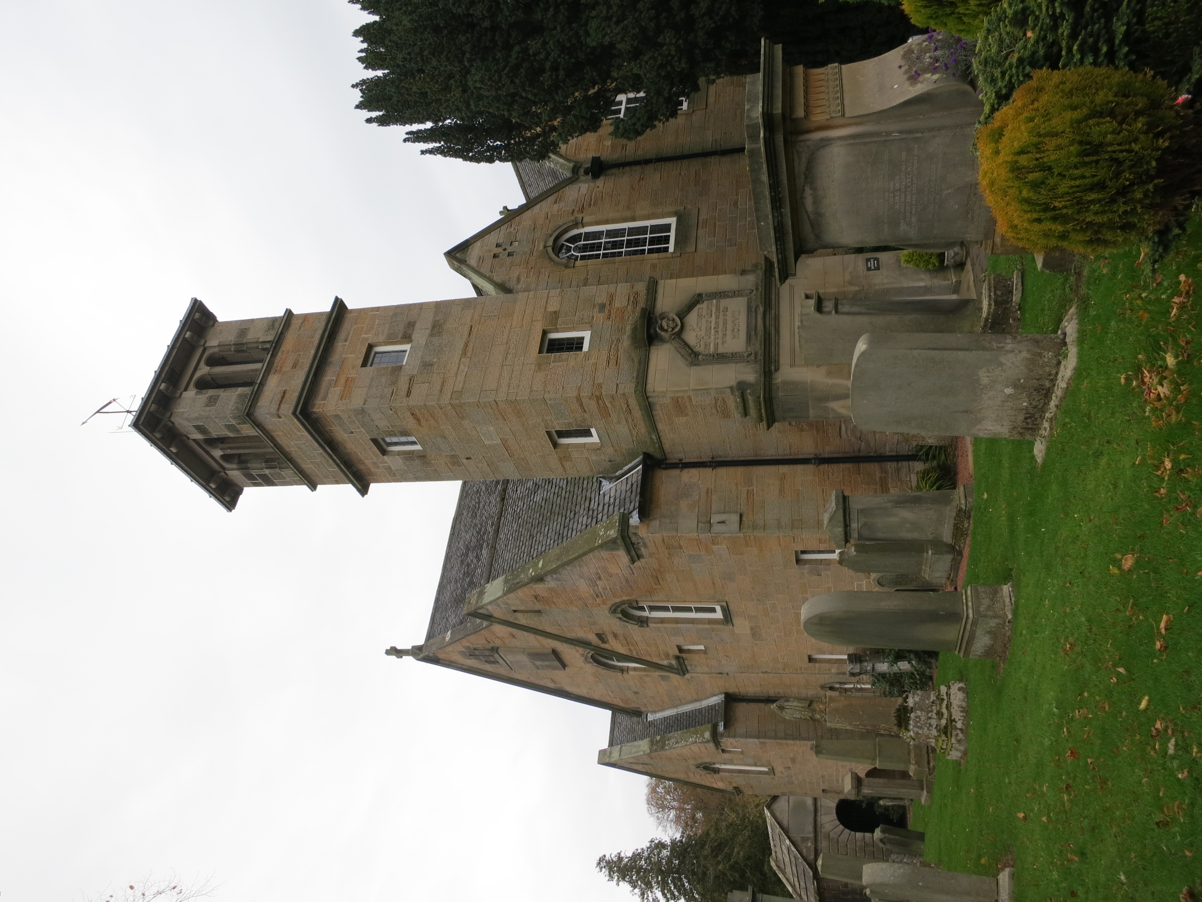
2. The church shown below is associated with a famous writer. Who is the writer, and what's the connection? (If you're feeling on top of your game, what's the tree on the right of the image got to do with the right?)
Again, for this I'd turn to maps. Since you know I didn't run very far from the flume (all the pictures were taken within a few minutes of each other), the simplest way to track this down is to check out the map and search for churches.
All I did was zoom out a bit and look for the church symbol. The Colinton Parish church shows up at the bottom of the map, only a few hundred yards away.
Alternatively, you could zoom out just a bit and do a search for:
[ church ]
then click on the "List View" option and see this:

Clearly, the Colinton church is closest.
The association with a writer?
[ Colinton Parish church author ]
leads us to many articles linking the famous novelist Robert Louis Stevenson with Colinton and this church in particular, since he spent many summers in Colinton when his grandfather was the parish minister. What's more, reading a bit farther down in the SERP, you'll find that a statue of RLS was set up just outside the parish church gate.

This is also available on SteetView, BTW.
And the tree? It's a yew treet (which the sign behind RLS says).
A query for:
[ robert louis stevenson yew tree church ]
quickly shows us the web page for "The Swing" which is the cafe in the courtyard of the church. So named, as their web page says,
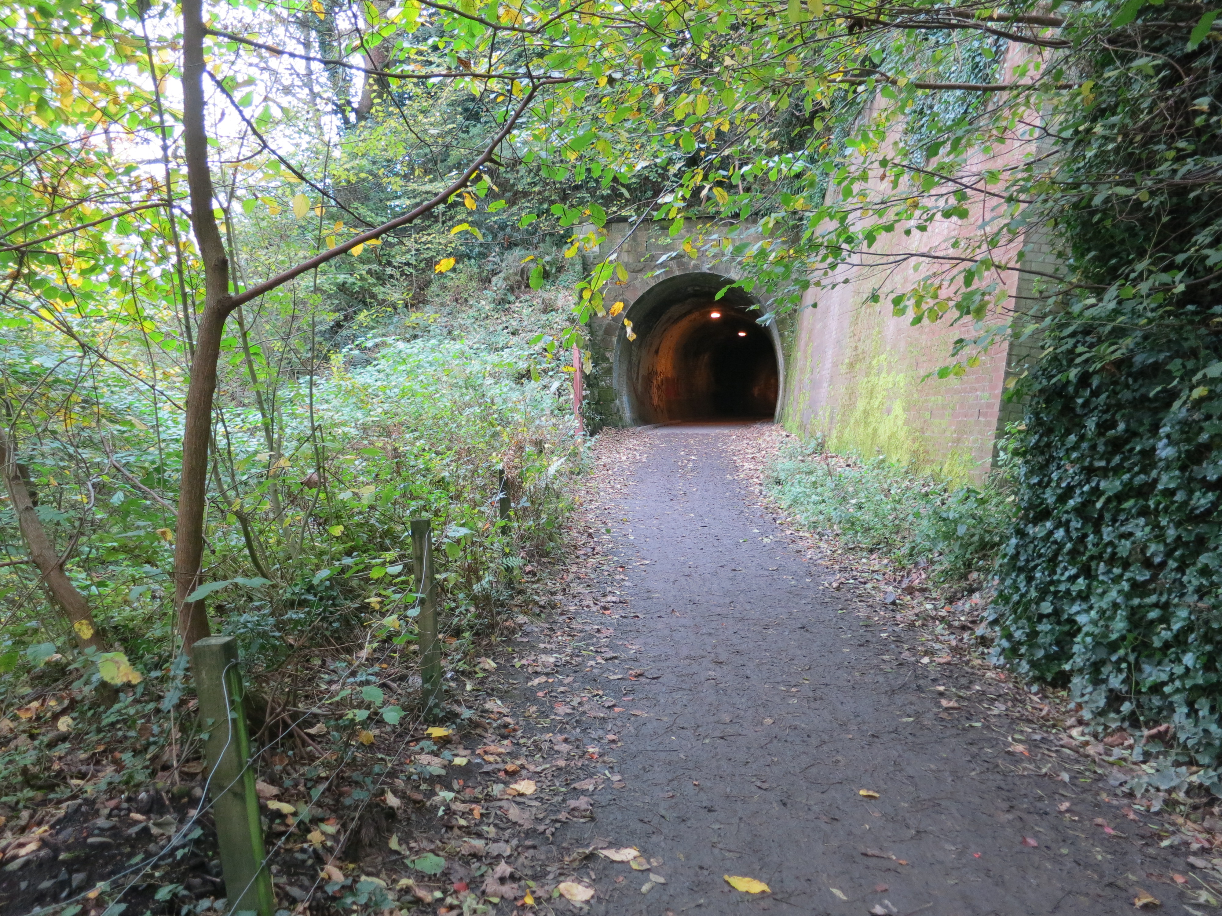
3. How long is this tunnel?
By now you can tell that a search for:
[ Colinton tunnel ]
will tell you everything you need, including links to Flickr pages with photos of the tunnel (not taken by me) that describe it as being 153 yards long. I double-sourced that just to check, and yes, all of the other pages describe it as between 153-154 yards (140.8 meters). This railway was central to the expansion of Edinburgh out into what is now the suburbs. (And FWIW, gave easy access to the mills along the Water of Leith.)
Search lessons:
Hope you found this an interesting Challenge. There are a couple of insights here as well.
1. Learning how to recognize features on maps is still a useful skill. That thin blue line next to a river is a dead giveaway of a flume. (See if you can spot some others in places you might know about!)
2. Remember to check the satellite views AND the archival Google Earth images. Only one of the images actually shows the weir. It's a fairly deep gorge, and Edinburgh is pretty far north so many of the pictures only show shadow. Check other sources.
3. The Maps list view is sometimes a very handy way to see a large number of hits on a single map. Check out this view of the coffee shops of downtown Boulder, CO. Where would YOU go for coffee??
And... because I know you're wondering, here's the poem that was inspired by the yew tree in the courtyard of the Colinton Parish church.
The Swing
How do you like to go up in a swing,
Up in the air so blue?
Oh, I do think it the pleasantest thing
Ever a child can do!
Up in the air and over the wall,
Till I can see so wide,
Rivers and trees and cattle and all
Over the countryside—
Till I look down on the garden green,
Down on the roof so brown—
Up in the air I go flying again,
Up in the air and down!
- Robert Louis Stevenson
Source: A Child's Garden of Verses (1999)
Obviously, I'm here, looking at these places in real time, but here's what I would have done, if I'd been somewhere else...
1. What is this strange obviously artificial waterway? Did it serve any particular function? If so, what?
 |
| The lat/long is 55.913090, -3.258981 Link to full-size photo. |
I would have just dropped this coordinate into Google Maps; that shows this....
If you've seen enough maps, you'll recognize this as a flume (or mill race) that's diverting water from the river (in this case, the poetically named "Water of Leith") to turn the wheel of a mill. Another clue can be seen in the name of the road at the top right--"Katesmill Rd"--I'm willing to bet there's a mill here.
If you switch to Satellite mode view, you can see something even more telling. Scan up-river from that point on the flume, and you can just barely see the suggestion of a weir (that is, a low-dam used to hold back water to feed the flume).
By switching to Google Earth, I was able to go back in time and get a clearer view of the weir. (You can see the riffles in the water below the weird.)
Another way to check would be to search for:
[ mill Water of Leith Katesmill Edinburgh ]
And you'll quickly find an official City of Edinburgh map that shows the flume at that location, along with a few history sites that tell us there are actually a couple of mills there--Kate's mill, originally a waulk (or fulling) mill was converted to a paper mill in 1653. It was remodelled in 1787 and then renamed Kate's Mill. 1832 it was owned by Alex Cowan and Son and there is now a private house on the mill site.) Redhall Mill, on the same flume started operation in 1718 making paper for banknotes. In 1742 the mill changed to the production of barley and later became a plastics factory. In 1970 Redhall Mill was converted into flats. (All this information is from the Sapphire project to collect Scottish mill history.)
Here are a couple more images to show you the ground truth at this site.
Here you can see an old mill wheel on the flume. A date engraved on the bridge (from which I took this picture) is 1839.
And just so you can correlate the above aerial image with a view of the weir from the ground, here's the weir.
 |
| Water of Leith weir that feeds Redhall and Kate's mills. |
2. The church shown below is associated with a famous writer. Who is the writer, and what's the connection? (If you're feeling on top of your game, what's the tree on the right of the image got to do with the right?)
 |
| Link to full-size photo. |
All I did was zoom out a bit and look for the church symbol. The Colinton Parish church shows up at the bottom of the map, only a few hundred yards away.
 |
| See the church icon in the lower right? |
[ church ]
then click on the "List View" option and see this:
Clearly, the Colinton church is closest.
The association with a writer?
[ Colinton Parish church author ]
leads us to many articles linking the famous novelist Robert Louis Stevenson with Colinton and this church in particular, since he spent many summers in Colinton when his grandfather was the parish minister. What's more, reading a bit farther down in the SERP, you'll find that a statue of RLS was set up just outside the parish church gate.
This is also available on SteetView, BTW.
And the tree? It's a yew treet (which the sign behind RLS says).
A query for:
[ robert louis stevenson yew tree church ]
quickly shows us the web page for "The Swing" which is the cafe in the courtyard of the church. So named, as their web page says,
"The name The Swing Café was inspired by a poem by Robert Louis Stevenson whose grandfather had been the minister at Colinton. Stevenson wrote the poem about the swing in the manse garden where he had played as a child. The location of the swing can be seen, outside the Dell Room window, in the old yewtree."
3. How long is this tunnel?
 |
| Link to full-size photo. |
By now you can tell that a search for:
[ Colinton tunnel ]
will tell you everything you need, including links to Flickr pages with photos of the tunnel (not taken by me) that describe it as being 153 yards long. I double-sourced that just to check, and yes, all of the other pages describe it as between 153-154 yards (140.8 meters). This railway was central to the expansion of Edinburgh out into what is now the suburbs. (And FWIW, gave easy access to the mills along the Water of Leith.)
Search lessons:
Hope you found this an interesting Challenge. There are a couple of insights here as well.
1. Learning how to recognize features on maps is still a useful skill. That thin blue line next to a river is a dead giveaway of a flume. (See if you can spot some others in places you might know about!)
2. Remember to check the satellite views AND the archival Google Earth images. Only one of the images actually shows the weir. It's a fairly deep gorge, and Edinburgh is pretty far north so many of the pictures only show shadow. Check other sources.
3. The Maps list view is sometimes a very handy way to see a large number of hits on a single map. Check out this view of the coffee shops of downtown Boulder, CO. Where would YOU go for coffee??
And... because I know you're wondering, here's the poem that was inspired by the yew tree in the courtyard of the Colinton Parish church.
The Swing
How do you like to go up in a swing,
Up in the air so blue?
Oh, I do think it the pleasantest thing
Ever a child can do!
Up in the air and over the wall,
Till I can see so wide,
Rivers and trees and cattle and all
Over the countryside—
Till I look down on the garden green,
Down on the roof so brown—
Up in the air I go flying again,
Up in the air and down!
- Robert Louis Stevenson
Source: A Child's Garden of Verses (1999)
Hello Dr. Russell. I have to say that I didn't know about words like flume or weir. Neither about finding feature in maps. I never thought about looking that. Good lesson. Thanks.
ReplyDelete"List View" is also great feature.
Thanks also for the poem.
Have an amazing weekend. Hope you enjoy your trip. I am sure you will find more amazing things to create other SearchResearch Challenges.
Ramón -- you can do this Challenge without knowing "flume" or "weir." I suspect that channel and dam would work about as well. Of course, you know about the Reverse Dictionary, so you could look up words like that.
DeleteAnd yes, that was really the whole point of this Challenge -- the things you can do with Maps as a query tool are pretty impressive.
Glad you enjoyed it!
Hello, Dr. Russell. Thanks for your post.
DeleteChannel and dam could work too. And, yes, "flume" and "weir" are not part of the solution. Just some of the new words that I learn in your challenges. Specially after
A skill of searching: Anti-reading (noticing unfamiliar words) and now, with the new
Google Translate Chrome extension is easier to learn and add to vocabulary.
Now I will research about [map reading features]
I thought Remmij would post something about this topic. He was hungry. Nice menus.
I look for the statue and I couldn't find a Photo in the Google Maps Imagery. Maybe, if you could add one in the map, Dr. Russell, now that you are near?
DeleteHere is the statue in Street View
would guess you are a Peet's person… but I was hungry so opted for Walnut (the Mind Eraser beverage sold it) but could have picked VCS - #6/cream, $1.25 coffee… perhaps another time.
ReplyDeleteMaps lists is a neat function I hadn't used - good tip.
Where's the hot joe spot in Auld Reekie/Edina?
…being that close — Fair Isle, Auld Haa
Keep the heid!
reading material, Boulder lore: Caballo Blanco
kinda True wiki
I am a Peet's guy, but when in Edinburgh, I like the Gran Cafe (near the Heart of Lothia) or Black Medicine.
ReplyDeleteFor the complete map, see: https://www.google.com/maps/search/coffee/@55.9529719,-3.18949,15z/am=t
Sorry: Typo. The "Heart of Midlothian"!
Deletethat's a spectrum - the Gran has macaroons… and the offerings are spectacular
Deletebut Black Medicine has a dark appeal - their twitter is twatted though… needs a bit of caffeine…
safe travels from the clutches of Old Tolbooth.
has much changed? - I like the suspended garmets, think Gormley's gents would have fit right in then too…
fwiw - when I initially opened the coffee map, the list was for shops near my current location even though the map was Edin'h… once I de-selected [coffee] in the search box
and reloaded the list got its Scot on…
Noo jist haud on! Gmaps - missing
ReplyDeleteLady O’Cathain would appreciate a private tutorial
mapping the new London
"In between we find those condemned to the hell of London for the sins of gluttony, lust and greed (I kid - although this new map of London does bear more than a passing resemblance to Dante's nine circles of Hell)."
handy supplemental maps info #4
Haste Ye Back!
Ma heid’s mince
I think we have covered in Google Maps the use of * in the search box to identify all places in the map view.
ReplyDeleteIn addition, I think we’ve talked about the cycling routes information. Getting Around [below search box] or just type [cycling] in the search box & green lines show you routes. It will also provide details about the various routes [Trails, Dedicated Lanes, Bicycle friendly roads & dirt/unpaved trails]. If you like trail running this will be useful. As well you can switch to Terrain below the search box. It even has ‘flights’ icon showing map route and prices.
Or perhaps its raining and you want to do something indoors, type [art and literature] to find galleries and book stores.
Clicking on any point now gives us the coordinates now. Click on the directions icon & you get the postal code.
To save your current map view for offline use on Android just type [ok maps] & save your map for offline use. Should would with IOS as well.
One thing I don’t understand is why Google Maps doesn’t provide legends like you would see on a paper map. It may be because you can create your own custom maps but there are default markers on the base map. Or the fact that a lot of markers are clickable. However the basics would be useful. It would be nice to see a list of icons and the various markings. Even a directional icon pointing north. I could go on but that’s beyond the point I want to make here.
…properly attired explorer
ReplyDeleteTheodolite
speaking of lists
Dr. Bucks
headed to the Bay area too