Curiosity is my secret superpower...

It could be yours too.
Most of my career has been driven by curiosity of one kind or another. How does AI work? How can people understand really complex devices?
Or, more generally, in my life, I'm one of those people who's always asking why, what, where, and how questions.
I remember that when search engines first became widely available AND when lots of content started being online, I realized that I could now start to answer my questions about as quickly as I could come up with them. I admit that I'm an information junkie who with a high need for cognition--it's a big part of who I am. Naturally, questions like the ones that popped up when I visited UC San Diego are intrinsic.
So, when I see things like this, I have a deep-seated drive to find out. And that, fundamentally, is why I became a research scientist.
But what about everyday living? Turns out that the research science skills transfer to every day life as well. Let's start with the first Curious Question...
1. What building is this? But why is it that particular dramatic shape? It's a striking, powerful building--what's the architect trying to communicate? What's the story here?
A quick search-by-image tells us that this is the Geisel Library at UCSD, an extraordinary example of a brutalist building that is fairly elegant and memorable. See the library's own description of their building, or read their "Building Guide."
The library was designed by renowned architect William Pereira in 1970, and was named for local La Jolla legends Audrey and Theodor Seuss Geisel (better known as Dr. Seuss) in 1995.
You can read the architect's thoughts about what he was trying to communicate with the building by reading the original report. He writes that the design needed to "convey to future generations the idea of the power and permanency of the knowledge contained inside it."
In particular, the scale and placement of the library in the center of campus needed a particularly impressive scale in order to communicate that message. A visitor to the building approaches it and knows that it is an important building simply by its columns and grand entrance. By default, the building becomes a landmark throughout the university, and makes it with a centralized meeting space. Its scale creates a sense of permanence, a sense of hands holding a world's worth of knowledge.
(Personal footnote: I've always loved the Geisel Library ever since I first visited back in the early 1990s, and was pleased to give a talk about my book, The Joy of Search, there in November, 2019. That talk wasn't recorded, but it was 99% the same as this talk I gave a week later in Spain.)
2. As I walked past the building, I found a truly extraordinary path on one side of the building. Without me telling you any more... can you find the "extraordinary path" and find out why it's there? What's the story here?
Without much to go on, a look-see is in order. Let's go to the satellite image.
A quick search on Google Maps of the library shows an intriguing path on the east side of the library with what looks like a snake's head at the top (see the label "Snake Path"):
 |
| Google Maps image of the Geisel Library |
And a close up:

That's a good image, but that Snake Path is a bit in the shadow. Luckily, Bing Maps has a somewhat better image:
 |
| Same location: Bing Maps |
You can see from the shadows that Bing's image was taken much later in the day.
Now--how to get the background info?
The obvious search for: [ snake path UCSD ] tells me that it's a piece of artwork by conceptual artist Alexis Smith (who unfortunately just passed away a few months ago--obit). In the library's article about the work we find: "Smith's work for the Stuart Collection, Snake Path, consists of a winding 560-foot-long, 10-foot-wide footpath in the form of a serpent, whose individual scales are hexagonal pieces of colored slate, and whose head is inlaid in the approach to the Geisel Library. The tail wraps around an existing concrete pathway as a snake would wrap itself around a tree limb. Along the way, the serpent's slightly crowned body circles around a small 'garden of Eden' with several fruit trees including an apple, a fig and a pomegranate."
Oddly, I had noticed the apple tree on a visit, and assumed it was a student's bit of whimsy--I didn't realize that it's part of the art installation.
3. I chatted with a student who told me that about there's a "fantastic piece of art" that's about 500 feet (152 meters) away from the path. "Just keep going," he said, "you'll find it." With just that direction I DID find it, but the artwork was a bit of a surprise... and it took some funny search skills to locate it. Can you find this artwork? What is it and where is it?
Here's what a roughly 500 foot radius is from the top of the Snake Path:

I added the red circle for you to see, but the black measuring line is made by control-clicking on the start point, then pulling out the control point to the distance you want to measure.
I tried various searches on Maps (like [ artworks near Geisel library ]), but I couldn't find anything that would work.
Clearly, I want a map, but how to get it.
Insight: just as there are different satellite views on different maps providers, maybe there are other maps that show just artwork. That makes sense--people often want to tour an area (such as a university campus) just to see the artwork. So, let's search for a map of such things.
The query that worked was:
[ art work on UCSD campus map ]
which led me to discover this map Concept3d Map of UCSD campus:

As you can see, this is an interactive map of the campus around the library with options to show both the Stuart Collection (of artworks) and just plain "Art" (i.e., things not in the Stuart Collection). If you click on each of the icons, at roughly 500 foot diameter from the top of the Snake Path, you quickly find this art installation in the Jacobs school of engineering buildings, "Fallen Star" from 2011.

You can quickly find the Wikipedia page for Fallen Star, which tells us that this artwork by South Korean artist Do Ho Suh us a cottage perched at an precarious angle on the top floor of the building.
 |
| P/C Wikimedia - "Fallen Star" is the light blue cottage stuck atop the engineering building. |
4. Lastly, on the night flight home (I flew from San Diego to San Jose, CA), I was looking out the windows on the right hand side and noticed the street lights extending northward from San Diego towards LA. About 12 mins into the flight, I saw a HUGE gap in the lights. It was dark, so I wasn't sure of exactly where I was, and I couldn't figure out why that place was so devoid of lighting. Can you figure it out? Where is that blank spot on the map? Why is it blank?
To answer this, you have to first figure out the flight path from San Diego to San Jose. Using one of the flight tracking services (e.g., FlightAware) you can search for evening flights from San Diego (SAN) to San Jose (SJC). Turns out that Southwest Airlines flies the most routes and it won't take long to find a flight path map. They look like this (zoomed in to show the region between San Diego and Los Angeles).
 |
| A typical flight from San Diego to San Jose (CA). P/C screenshot from FlightAware |
You can then look for the same section of the California coast with a regular map:

If you look at the FlightAware progress chart, you can see the climb out of San Diego, reaching the cruising altitude, and estimate the average speed for the first 12 minutes of the flight (remember that I saw the blank spot around 12 minutes into the flight).

It's difficult to get an exact speed, but let's estimate it at 250 mph (that includes the takeoff, etc.). Flying for 12 minutes at 250 mph takes one about 50 miles up the coast along the flight path. If you use the distance measuring tool again, you'll get this figure:

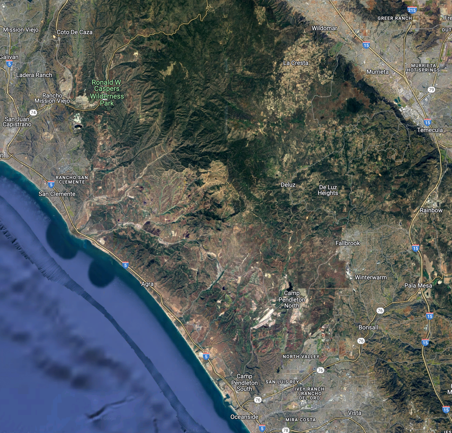
So, I was somewhere off the coast between San Clemente and Oceanside. Just looking at the map like this suggests that there's a big gap, an empty space, just east of the 5 freeway, between those two cities.
Zooming in and taking a satellite image view, we see:
That looks suspiciously empty. But I'd REALLY like to see what this region looks like at night. How can we do that?
I did a search for:
[ night time view of US ]
And quickly discovered NASA's Earth Observatory which has a truly great collection of images, including some of the US taken at night. (High res image of the US at night.)
You can zoom in on that image to find this overview of Southern California at night.

Spend a couple of minutes aligning the image with the map from above:

You can see the dark region just to the right of the flightline. Zooming in on the map, you'll see that this area is home to Camp Pendelton, the San Mateo Wilderness, and Ronald W. Caspers Wilderness Park. A quick search to find map of parklands in CA:
[ map of california parks ]
leads to a nice interactive map by Databayou that lets you zoom into this region and find out all the details.
Even though Southern California has a LOT of cities and built-up areas, there are still substantial parts of the state that are basically blanks. For someone like me, looking for parts of the world that I don't know about or understand, this is just wonderful.
SearchResearch Lessons
1. Remember there are multiple mapping systems out there. We certainly know about Google and Bing maps--they're super easy to use and are relatively up-to-date. Remember that they have DIFFERENT images--sometimes one is better than the other, so check both. Also remember that there are other places to get satellite images--remember NASA has great collections, mostly searchable.
2. Use the tools that are in the maps systems. Google and Bing maps both let you measure distances easily, they have ways to see the 3D nature of places, and can give you different views as well (e.g., topographic maps or Streetview).
3. Combining data sources is often the key to solving Challenges. As you see, we had to use maps + distance measures + FlightAware + NASA nighttime images to figure out what I was seeing out the window. Combining data is often the way to go!
Extra Commentary: Thanks to all of our regular SRSers who continually amaze me. Special thanks to Remmij who reminded me that there is a carillon at the Geisel Library. It's a common sound in the central campus that's absolutely charming. (Well worth the read.) Thanks also to Krossbow, who wrote his response in Seussian Rhyme! With AI support, admittedly. Still very clever.
In doing this, I also learned that Pereria was the architect for MY undergraduate library at UC Irvine, which is also, oddly enough, where Alexis Smith went to school, although we did not overlap.
Keep searching!
instructive, as always Dr.R… who knew Southwest flew that route 217 times a day ;) – those flights alone could be a endless source for things/passengers to be curious about…
ReplyDelete"2] The Pereira windows on Steinhaus Hall were removed in 2008 as part of an earthquake retrofit, and replaced by a very pedestrian facade. I found this historic image on the Web."
https://parkerlab.bio.uci.edu/UCI/Pereira.html
https://www.irvinestandard.com/2021/the-story-of-william-pereira-irvines-original-planner/
I was an AF reader at one time…
https://www.artforum.com/news/alexis-smith-dies-19492024-545853/
https://www.artforum.com/events/alexis-smith-10-250783/
class of 2010, which raised $8,538.82
https://news.uci.edu/2011/05/05/uci-rings-in-new-set-of-campus-bells/
https://special.lib.uci.edu/collections/anteater-chronicles/architecture/unbuilt-visions
http://modernistarchitecture.blogspot.com/2015/03/university-of-california-riverside.html
one carillon playing example (non-elecronic) and another - Glockenspiel (BELLs) - as close as I could find, but I thought it would make a good riff to toll over a campus…
Deleteon the way to that 8:00AM Applied AI class…
https://youtu.be/8GtHzCp0Ck8?si=i--TAZFYUGhyJZjg
https://youtu.be/wW0-ckfNZeM?si=bg79NVmA2EvVhlhJ
For all the times I've been at Irvine, I've never heard the bells. Alas.
Deletewhile sipping a triple espresso cappuccino… (184.14 Mexican Peso - a bargain)
ReplyDeleteand recalling past sounds…
enjoying the ambiance of UC-Amboy… no Ivy.
https://roadtrippers.com/wp-content/uploads/2019/06/amboy-postal-service-1160x772.jpg
https://youtu.be/Mip30YF1iuo?si=MiJeE6abs5ePXofK
https://www.youtube.com/@the_miracle_aligner
This deserves a reply: https://www.youtube.com/watch?v=cErgMJSgpv0
DeleteI've been rolled
Deletewhere has the time gone?
https://www.youtube.com/watch?v=dOmYZOQrWso
Æppel - hæmedrím orþanc
(AI integration attempt) beta/Fall - SIRI superpower? curiously non-curious
https://shorturl.at/w5giv
duckrolled…
https://shorturl.at/JHkui
https://youtu.be/H8ZH_mkfPUY?si=QtcK_WbB_mRQ4Tsi
https://imgbox.com/MZXwvBci
https://i.imgur.com/pct5CH8.gif
https://shorturl.at/KnIop
https://youtu.be/gvJnOtRn4ho?si=O0Ppq8XJcZygG60x
https://imgbox.com/XMyHeB61
https://imgbox.com/fyPtPPBp
I lacked the YT AI…
Deletehttps://youtu.be/Q_EYoV1kZWk
the "other Rick roll" or torta/sandwich
Deletehttps://www.youtube.com/watch?v=3CqFUN7xjos