Thursday, November 18, 2021

Answer: Why is the Carquinez Strait so undeveloped?

 This kind of question is difficult to answer... 


The Challenge was:  "Why is the Carquinez Strait so undeveloped on the south side of the channel?"  

As evidence, I made this map to highlight the area that is still most open range lands. 


I noticed that while there's a lot of development (houses, shopping centers, etc.) on the north side of the strait, there's very little on the south side.  
So... why is there such a big gap between Crockett and Martinez, a large region of undeveloped land. Let me repeat this week's Challenge:  

1. Can you figure out what's going on in this stretch of otherwise unused coastline?  Is it really the "Lost Coast" of the North Bay? Why so... empty?  What didn't happened here?   

As I mentioned, getting simple answers to questions like this can be difficult.  This is the dog that didn't bark--the missing piece, a non-event, a gap in what otherwise seems like a normal path of progress.  

To answer this, we're going to have to create some counterfactual rationale--that's the kind of question you get when you suppose that something didn't happen, and ask why it didn't.  So, what prevented the south side of the strait from being more developed?  (Or, ask Sherlock Holmes might have said as a counterfactual question, "Why didn't the dog bark?," sometimes referred to as the "curious incident of the dog in the night time.")  

My first thought was to try and see some archival images and maps to see what we might see.  Of course, I turned to Google Earth and its collection of archival images.  Here are 3 images of the area that I've marked up with a dashed line to indicate where development DID occur.  

Google Earth - 1939

Google Earth 1993

Google Earth 2021

With these three maps I was checking to see if perhaps there was some underlying geological reason that would make this area un-developable... but I don't see anything.  What's striking about this dashed line is how much it looks like the random rectangles you see in city-use planning diagrams.  There's a blob sticking into the Rancho in the lower right, and the edge isn't one long straight line... it's pretty ziggy-zaggy.  

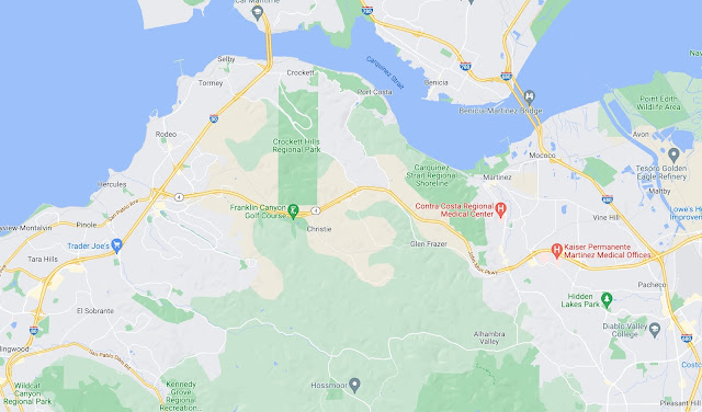
Here's a Google Maps version of the same area today shown as a traditional map.  Here what I'm looking for are place names that I can use to do searches of archival content.  


Here, a couple of place names leap to the fore: "Port Costa" "Crockett Hills" (a regional park), and "Carquinez Straits" (another regional park), "Martinez."  If you zoom in a bit more, you'll also see "Bull Valley" and "Eckley" as other place names of interest.  

For each of these place names, I did a small deep dive, usually starting with a query like this: 

     [ history Port Costa ] 
     [ history Eckley ] 
     [ history Martinez ] 


My goal in doing these dives is to learn as much about the place (history, dates, people, place names) as possible.  I keep a little running set of notes as I do this just to keep them all straight.  (Truthfully, I do this on a piece of paper.  It's fast, easy, and I can easily makes edits and links to other things as they come up.)  

To tell the truth, I spent a few very pleasant hours doing this, following interesting stories as they came up, but mostly learning that this triangle of land never seemed to have much development on it.  

My first dive was to figure out who owns this part of California.  My dive research told me that this area was called Rancho Cañada del Hambre y las Bolsas.  (I found this out after seeing several maps from the late 1800s with that as the place name... see below.)  The ranch was a 13,354-acre (54.04 km2) Mexican land grant that was given in 1842 by Governor Juan Alvarado to Teodora Soto. The grant consisted of "Cañada del Hambre" which means "Valley of Hunger" in Spanish, and "Las Bolsas del Hambre" which refers to "pockets" of land.

The rancho extended from present day Crockett to Martinez and south to Lafayette.

Here's a section of the plat from 1866 that I found at the Online Archive of California by searching for: 

     [ plat Rancho Canada del Hambre ] 

(Why the word "plat"?  Because I know that term means a kind of large-scale map often used in land surveying and land-use planning. It's specialized language.)  

Plat of the rancho, 1866. 

On this plat you can see a note marking "Ramon Estudillo's home" in the upper left, as well as "Big Bull Valley" and "Little Bull Valley."  These names might come in handy later, so I write them down on my notes.  

But I kept looking for more vintage maps, searching through the results of my search: 

     [ maps Contra Costa county ] 

By just clicking through the images, I was able to find several over the years.  

Here's one I found on Wikipedia: as you can see, 30 years later, some development has taken place along the north (the towns of Crockett, Aldona, and Port Costa), and most significantly, to the east (Martinez). 

Rancho Cañada del Hambre (1894) per Wikipedia, USGS Karquinez Quad.

And below is another survey from 1898, just a few years later showing even more development, especially in Benicia and Port Costa. There are also sections marked off.  

Rancho Cañada del Hambre (1898) Theodore Wagner and company. Here you can see major divisions of the land, in some cases showing who bought them, such as "McNear" in the lower right.  


The first thing I noticed after I found these maps was the immense similarity to my original chart (second figure from the top).  What are the chances?  I didn't know about this Rancho when I drew that diagram... I was just highlighting the blank spot on the map.  

Of course, I did a search for the history of Ranch Cañada del Hambre, and found a Wikipedia article, this told me that the grant for the rancho made to Teodora Soto was "sobrante," (that is, a remainder after the Rancho El Pinole on the west and the Rancho Las Juntas on the east were sold). It was estimated that the sobrante would contain three square leagues of land. (If you ask Google [ 3 square leagues of land in acres ] you'll find that it's 22,000 acres, Teodora Soto was married to Desiderio Briones.  (Now that's interesting...  Why?  Because the grant was made to a woman, which wasn't much done at the time, AND we've seen that name, Briones, before.  Desiderio was the nephew of Juana Briones, who owned land in San Francisco at this time.  See SRS from March 8, 2018-- "How did this group of houses get to be here?" Two powerful Californio women who end up related to each other?)  

In any case, after the Mexican-American War, the 1848 Treaty of Guadalupe Hidalgo provided that the Mexican land grants would be honored. As required by the Land Act of 1851, a claim for Rancho Cañada del Hambre y Las Bolsas was filed with the Public Land Commission in 1852, and the grant was patented to Teodora Soto in 1866. 

I spent many happy hours looking up who owned which parcel of land, and where it went... but we're REALLY interested in why it's undeveloped today.  

I was curious if this land was EVER developed, so I started searching for maps of Contra Costa county.  I did the usual library searches (the Library of Congress has a great map collection of the area), but oddly, I found that the best source of maps during the time-span of 1900 - 2000 was.. Etsy and eBay!!  

Yes, there are LOTS of maps of Contra Costa County from all during that century.  Here are just a few of the many I found using the eBay search:

     [ Contra Costa county map 1970 ]   -- or whatever year you'd like 

A map from eBay, published by Chevron in 1970.  It shows a large, still undeveloped section of Contra Costa county south of Crockett and Port Costa, west of Martinez, and east of Rodeo.  

  
Another map of the area from 1990, published by Gousha, again showing a blank space. 
Sorry this is so low res--it's the best I could find--but it's convincingly empty.
You can clearly see Port Costa at the top.  It's a small village, and if it shows up on the map,
then other villages in the blank space would have ALSO appeared... and they don't.   


In any case, all of these maps show the old Rancho as agricultural lands.  Clearly, the Rancho was divided up, and kept as farms or ranches over the years.  

Another approach would be to search for land use maps.  "Land use" is often used to describe how land is zoned and how the city or county or state plans to use that area.  A search for: 

     [ land use map Contra Costa county ] 

leads to this current map from the county government, showing the zoning / plans for land use in the county: 

Current (2021) land use map of north Contra Costa county.  Here, blue is public/semi-public lands (such as highway right-of-way), while green is parkland/preserves.  The pea-soup green is marked as "agricultural" land.  P/C Contra Costa County.  


Perhaps part of the answer can be seen in who owns these parcels now.  

The easiest way to learn that information is via the county assessor's office. (Why the assessor?  They have all the information needed to assess the taxes on a piece of land.  And usually, in the US at least, they also offer a web-site with a GIS system to find out about each parcel.)  

A search for: 

     [ Contra Costa county assessor ] 


leads quickly to the Assessor's website, and it's a single click to get to the GIS tool that lets you lookup ownership of land parcels.  

Here's an example: 

Contra Costa Assessor's map of parcel 368-100-002, just south of the town of Port Costa.

If you poke around in the Assessor's map, you'll find that all of the parcels are all labeled as agricultural land, reserved in a "Land Bank" (set aside by the local government), parklands, or are federally owned (especially along the waterfront).  So the Assessor's map (who you would plausibly has ground truth) algns with the land use map above.  

But how did it get to be this way?  

If we look back into the newspapers of the day, you'll find the record of many sales published in the local press.  (Back in the day, land transactions had to be published to become part of the public record.)  If you search in Newspapers.com (or your favorite digital news archive, which for me is the California Digital Newspaper Collection).  

If you do the obvious searches (e.g., [ Rancho Canada del Hambre ] or [ Rancho Briones ]), you'll find a LOT of land transactions.  Here's one such sale (part of my deep dive taught me that Rancho del Pinole was just to the SW of Rancho Canada del Hambre):   

Contra Costa Gazette, May 24, 1907


But some of these notices also tell us who owned what, and when, and how much they owned.  In the San Francisco Call of March 20, 1907, I found this notice of someone applying for a mortgage: 

George McNear mortgaged 3866 acres (his part of the Rancho) to raise some quick cash. 

And of course, by 1916, the Rancho was largely up for sale.  

From San Luis Obispo Daily Telegram, Dec 16, 1916

And if you keep searching, you'll find the sales, transfers, and gifts that were made over the years.  200 acres here, 159 there--but always as unimproved land on the margin of the main rancho.  

There are two other resources I turn to for this kind of geographical information in an attempt to complete the story:  Wikimapia and OpenStreetMap.  Both are collaborative efforts to crowdsource all kinds of geodata, and since they're slightly different, you can sometimes find gold in the different views.  Here's the Wikimapia view: 

You can see that in Wikimapia's view, the rancho is either parkland, ag land, or John A De Martini land, still held as a ranch.  


By contrast, here's the OpenStreetMap's perspective: 


As you can see, they have very different views on what's going on the old Rancho.  The Crockett Hills Regional Park is the same, but the De Martini Ranch isn't marked on the OSM plan.  And, as you can see, the bulk of the Rancho is either Di Martini ranchland, or preserves.  

Bottom Line:  How did this all stay so undeveloped? 


There isn't a single neat, short answer, there usually isn't for counterfactual questions.  But the case is pretty clear that this area has always been seen (and valued) as agricultural land, even as it was being broken up and sold off in smaller fragments. Remember that in the late 1800's and early 1900's, this ranchland was also intensively farmed for wheat... which was then shipped out through Port Costa until the bridges made it easier and cheaper to use railcars.  

Basically, the story seems to be this:  Over the years, several families had large tracts of land that they slowly sold off, but almost always for ranching or farming uses.  From the 1970s until today, some of those sales and gifts were to the county for the purpose of preserving open space.  That's ultimately how the Crockett Preserve and the Carquinez Straits Regional Shoreline came to be.  


This post is already pretty long:  So I'll write up the  SRS lessons tomorrow.  Stay tuned!  

Search on! 


Wednesday, November 3, 2021

SearchResearch Challenge (11/3/21): Why is the Carquinez Strait so undeveloped?

It's a mystery to me... 


As I flew out of the San Francisco airport on a clear fall day, I noticed a vast imbalance in the landscape below, an asymmetry that I couldn't quite understand.  See that image above?  Notice anything odd about it?  


I noticed that while there's a lot of development (houses, shopping centers, etc.) on the north side of the strait, there's very little on the south side.  

This region of the greater San Francisco Bay region is a series of towns that have varied in size and importance over the years.  The lone village in this singular blank spot is Port Costa, and just to the west of that village is Crockett, home of the C&H Sugar factory.  If you shift to the east, you'll find Martinez, the former Pony Express stop, county seat, and home to John Muir for the last third of his life.  

But there's a big gap between Crockett and Martinez, a large region of undeveloped land.  It seems inconceivable to me that there wouldn't be SOME development between those two cities.  Why isn’t it more like Cinque Terre, with trails, small villages, fine restaurants and not just a strip of underappreciated shoreline?  Mind you, I'm not advocating for that--I love this stretch of the Carquinez Strait and I appreciate the quiet when I visit, but I'm puzzled.  Why is it like that?  So here's this week's Challenge:  

1. Can you figure out what's going on in this stretch of otherwise unused coastline?  Is it really the "Lost Coast" of the North Bay? Why so... empty?  What didn't happened here?   

The perfect answer will probably be some kind of historical briefing: What happened to this stretch of the coast?  Why was it left alone while everything around it turned into cities?  

Of course, in some sense, this is the dog that didn't bark--the missing piece.  And that's always a bit difficult.  

So be sure to tell us HOW you figured this out!   Let us all know in the comments.  

Search on!  

Here are two more images to give you a bit of context and maybe a few clues.  

The Carquinez Strait is just south of Vallejo (top center) and Concord (slightly down and to the right).  


Monday, November 1, 2021

Celebration! 4M+ reads!


A small celebration is in order...

... in total, SRS has, to date ...  


... this week, SearchResearch passed 4 million reads since its inception in January of 2010.  

I know some number of those reads are by bots, but I suspect the majority are all human readers--mostly people like you, who want to improve their search skills.  

A little more data for context: 

     - SRS gets around 11,000 reads / week 

     - this is the 1250th blog post 

     - you have made 12,234 comments 

     - if every reader spent 1 minute reading,
        that's 7.6 years of someone reading (at 24 hours/day)  

Thanks to all of you, the loyal readers of SearchResearch!  


Forward... to 8 million reads!  

Search on! 


Thursday, October 28, 2021

Update: Are these documentaries difficult to find?

Another lesson... 

As we've discussed before, in general, if you just ASK people nicely, they'll often point you to what you seek.  We've seen this before in getting copies of papers and articles that are behind paywalls, and in getting preprints of stories that never quite appeared in print.  

Following that precept, I managed to locate the creator of "The Vanishing Cape Breton Fiddler," Ron MacInnis, and wrote to him asking for advice about where to find the video. 

He wrote back almost instantly and pointed me to an open-access copy of the film!  

There's no way to pay for streaming or access, but as Ron pointed out to me, "..a most appropriate and effective way to show support would be to make a donation to the Celtic Colours festival, who have done great work in preserving the culture."  

Thanks, Ron. 

Since I learned about the documentary when I attended the music festival in Cape Breton,  I'll donate now!   (And, if you find yourself in the area in October, consider dropping by the festival--it was truly wonderful.)  


Lesson learned:  Ask people nicely and they're often very willing to help out.  


Wednesday, October 27, 2021

Answer: Are these documentaries difficult to find?

 Documentary and older films are a

   quiet pleasure... 

But finding them can be hard.  

What are the tips you use for finding older and less common films?  (Or, more specifically, videos of films... although in an era when all movie houses seem to be going digital, I'm not sure what the distinction really is any more.) 

Can you find these films so I can watch them online?  Here's the list I'd like to find.  


1. Garlic is as Good as Ten Mothers.  I know this is by Les Blank, I know it's from 1980, it's about garlic, and maybe it's about motherhood, but that's all I know.  

Much to my surprise, the obvious Google query gives a bunch of results that highlight the film. And if you click on the Videos tab, you'll see: 


Notice that little white number in the lower left corner of each video icon?  That's the run time of that particular video.  You can easily see that these are all trailers or shorts for the documentary.  

But if you look down the column a bit, you'll see one without any runtime--that's the film (apparently the entire 50 minute film) hosted at U. Wisconsin-Madison with a transcript of what's being said.  

And of course, one of the main results leads to the Les Blank site, which then points to the Criterion film site, which hosts (and sells) the film.  

Another approach, as pointed out by Ramón, is to check out the JustWatch.com site.  (Be sure to set the country code to your locale.)  JustWatch is a fairly remarkable site that lists LOTS of films and their availability all over the web.  (It's good enough that I often check it whenever I'm looking for a somewhat obscure movie.)  

As cmarlowe very correctly points out: "If you have a library card and your library subscribes to Kanopy or you are a student or faculty member a university that subscribes many full-length films are available to watch including Garlic is as Good as Ten Mothers and Metropolis."  That's absolutely correct.  Yet another reason to get a good library card.  

Arthur Weiss also commented that "Wikipedia's page gave some suggestions e.g. TCM.com (which requires a VPN if outside the US)..."  

Footnote:  The Wikipedia page on the movie has a fascinating quote from a Washington Post article about the movie:  "The director recommends that, when the film is shown, a toaster oven containing several heads of garlic be turned on in the rear of the theater, unbeknownst to the audience, with the intended result that approximately halfway through the showing the entire theater will be filled with the smell of garlic..."  

Footnote to the Footnote:  I live not far from Gilroy, where most of the movie was made.  When you drive through Gilroy during garlic harvest time, the scent of garlic is pretty powerful.  It's heady stuff, certainly enough to make a popular documentary!  


2. Metropolis.  Not a documentary, but a super famous German expressionist film from 1927.  Can you find it online? 

The query [ Metropolis ] brings lots of results--the usual Wikipedia page, along with IMBD and others--but if you click on the Videos tab, you'll find many trailers (look at the white numbers for running times), including one video that shows up as 2:19:14.  That is, 2 hours, 19 minutes, 14 seconds long.  (This video is in fantastic shape; excellent conversion from film to digital.  Note that it has German intertitles.)  

An issue with older (and popular) movies is that there might multiple versions of the same film.  Wikipedia points out that Metropolis has been recut many times. 153 minutes (original)

116 minutes (1927 edit)

105–107 minutes (1927 US)

128 minutes (1927 UK)

118 minutes (August 1927)

91 minutes (1936)

83 minutes (1984)

124 minutes (2001)

148 minutes (2010)

 But we were able to find at least one free version.  JustWatch.com shows MANY different versions, most for very small amounts of money.  But since Metropolis is widely regarded as one of the greatest and most influential films ever made, it's probably worth a few bucks to pay for the version you'd like to see.  (Note that Kanopy also has their own version.)  


3. The Disappearing Cape Breton Violinist.  My handwriting was shaky on this one, so the title might be a little off.  I'd still like to watch it, though.  Can you find a link to an online video of this? 

As everyone noted, my handwriting (and memory!) was more than a little off.  Luckily, Google spell-corrects "the disappearing Cape Breton violinist" to "The Vanishing Cape Breton Fiddler."  When you think of it, that's more than a mere spell correction, it's actually fixing a major memory bug!  

It's not hard to find excerpts of the full film, but finding the entire documentary is difficult.  Like many of you, I found where it was made (Canada) and who produced it (Canadian Broadcasting Corporation, CBC).  

And, as AlmadenMike notes:  

The only clue I found that Arthur did not include in his excellent response was from a comment by Ron MacInnis himself to the YouTube Part1 video that included: "CBC owns the contract [for the documentary] but kindly gave rights to the Celtic Music Interpretive Center in Cape Breton.

Here's a link to the CMIC archives

But while it has online a (partial) list of the books, magazines and publications that the archives contains, there is apparently no similar list for its audio/video collections. And there certainly does not appear to be any free viewing of the MacInnis' documentary via the CMIC site.

And that, my friends, is about as close as we've come to finding it.  

I checked all of the usual places (JustWatch.com, YouTube, Vimeo, Hulu, etc.) but wasn't able to find a video of the entire thing.  I found pieces of the whole, but not the film in its entirety.  (A nine-minute part. A seven-minute part. A playlist with six different videos.)

By searching for Ron MacInnis, I was able to find lots of detail about him and a bit about the film.  His LinkedIn profile led me to VanishingFiddler.com, which is long gone. (Here's a link to the Internet Archive capture.)  On that archived page he writes:

"..in 1972,   sorry to see the passing of traditional Scottish music in my native Cape Breton in Canada, I wrote and narrated a CBC network television program that lamented my sadness at its passing."  

So we know it exists.  

The page promises a downloadable version, but it doesn't seem to have happened (or it's gone away).  

I also found a sequel video, The Return of the Vanishing Cape Breton Fiddler... or at least several references to it.  Here's a video by Ron MacInnis talking about the project, and here's a reference to a showing of the video (in 2017).  But I've been unable to find the video itself--even though I know it exists.  (So, naturally, I wrote to MacInnis--if I get a reply, I'll let you know.)  


SearchResearch Lessons 

This Challenge was a mix of easy (Metropolis) and very difficult (Cape Breton Fiddler).  A few lessons: 

1. Sometimes you can find the entire video, but it might not be obviously labeled as such.  That was the case with the videos of Garlic--the full-length version IS available, you just have to pay attention. 

2. Videos vary in quality.. often quite a bit.  We could find versions of Metropolis, but they come in different levels of fidelity and different kinds of edits.  Be aware that you might not quickly find the canonical version.  

3. Clues for searching can come from anywhere, including YouTube video comments!  As Arthur noted, clues for additional places to search can come in many forms.  (As always, use hints and clue with caution.  Listen, but verify.)  

4. Sometimes a content aggregator is your best bet.  We found the JustWatch.com site to be a useful aggregator of information about videos that come in many forms scattered over many places.  Google Video search is good, but JustWatch adds value to the video search results by pointing to media outlets that aren't scanned by Google.  They also collect a lot of metadata about the film that's incredibly useful.  

5. Sometimes you can only find fragments...  That's the case with the Vanishing Cape Breton Fiddler--we found bits, but not the whole.  This search will go onto my queue as "something to watch for" over the next few years.  I hope to find something!  

Search on! 

Friday, October 22, 2021

SearchResearch Challenge (10/22/21): Are these documentaries difficult to find?

 Documentary and older films are a
   quiet pleasure... 

... I love watching them, but sometimes find them a bit difficult to find.  Maybe you have this problem as well.  

Ideally, I'd like to watch them for free, but I'm totally happy to pay for the privilege of watching, if I can find a reasonable price.  

Usually, when I see a reference to a documentary I want to watch, I jot the name down on a slip of paper.  Then, a few days, weeks (or years!) later, I try to find them online.  

Sometimes I admit that my writing isn't as careful as it should be, so I end up having to search for films whose names might not be exactly right.  

But this is something we all face--finding something that's relatively obscure, and perhaps with a little error that crept in along the way.  

Can you find these films so I can watch them online?  


1. Garlic is as Good as Ten Mothers.  I know this is by Les Blank, it's about garlic, and maybe it's about motherhood, but that's all I know.  

2. Metropolis.  Not a documentary, but a super famous German expressionist film from 1927.  Can you find it online? 

3. The Disappearing Cape Breton Violinist.  My handwriting was shaky on this one, so the title might be a little off.  I'd still like to watch it, though.  Can you find a link to an online video of this? 


Note that I don't want to see the trailers for these movies, but the actual full-length production.  

As always, I'm interested in HOW you found these videos of these.  Tell us so we can all learn!  


Are there videos that you'd like to see that YOU find difficult to locate?  Bring them up here, perhaps the crack SRS team can help you out! 


Search on! 


P.S.  The math analysis of the shadow-date-time problem will be my next post early next week.  


Wednesday, October 20, 2021

Answer (3): Can you get the time and date from a shadow?

 Can you actually get the time and date from just a shadow?  (installment #3) 


This is part 3 of the time & date from a shadow Challenge. This is all about using tools, and checking to make sure the tools work the way you think!   

-----------


We're back trying to figure out when this satellite photo was taken.  


1.  What day and time-of-day was this photograph taken?  

In our last post, I tried using a lot of photographic resources, but didn't get very far.  Turns out that while the Skytree has a LOT of photos, very few are the ones I need!  


But I found that by using SunCalc in an interactive mode, I could move the time slider at the top of the page (that's the sun image at the top).  You can check it out here.  In particular, if you dial in Jan 29, 2020 at 10:42AM, you'll see a modeled shadow that looks just like the photo above! 


Using Suncalc, I can find a time/date that shows the shadow just over the Sumida bridge!  
I just read the time/date off the panel on the left side.  10:42AM, Jan 29, 2020


(And with even more playing around, you'll quickly realize that the shadow is ALSO the same position on Nov 12, at 10:14AM.  More on this later.)  

But now I'm curious: Is THIS model correct?  

I did a search to see if I could find another shadow-casting / modeling online app, and I found a few.  The one that appealed to me the most is Shadowmap, which, if you play around with it, can give you a very similar image (note that the underlying base map of Shadowmap doesn't include the Sumida bridge, so I had to guesstimate the position.  Luckily, it's pretty close to what SunCalc says... 

....although Shadowmap has the time as 11:12AM on Jan 29, 2020.  

By using ShadowMap in the same way, I could find an identical map model... but for a slightly different time.  Here, the time is shown as 11:12AM on Jan 29, 2020.  Why is it 30 minutes different than SunCalc? 

So... the two models are very, very close... 

   SunCalc            10:42 AM 
   Shadowmap          11:12 AM 

but 30 minutes difference is annoying.  Which one is closer to reality?  How can I check?  

I know.  I can go out and measure a real building, take a photo of a real shadow, and then see what the predictions are!  

Early Sunday morning, I went off to a nearby building and took a photo of its shadow at 9:03AM on Oct 17, 2021.  Here's what I found--the shadow of the building goes out into the street almost to the center--it's about 1m short of the center.  


(Side note:  Turns out that it's hard to get clean photos of Silicon Valley building shadows.  They tend to be surrounded by trees, which makes getting the edge of the shadow somewhat difficult.  This is the best I could do on Sunday morning!) 

Here's what Shadowmap predicts as the building shadow for this time (the green triangle shows where I'm standing, looking down the street to the south).  As you can see, the Shadowmap shows the shadow going about halfway out into the street.  


 This is pretty great!  The model aligns pretty closely with the real image! 

 Then I turned to SunCalc and asked the same question, what's the prediction?  Here's what SunCalc shows as the shadow prediction for 9:03AM. 


(I've zoomed in a bit so you can see what's going on.  Note that the predicted shadow doesn't quite hit the street.)  

Well... huh.  That's a little short.  

But by playing around with the time slider, I found that the shadow hits exactly that spot in the middle of the street at 8:42AM, which is 30 minutes off the Shadowmap prediction.  There's that 30 minute difference again!  


Let's recap what we know.  

First, we know we can find online shadow modeling tools that can help figure out what DATE a particular shadow falls on a given place.  By tweaking the dials, we can even figure out exactly what TIME that shadow falls on that place.  

In our case, we wanted to know when the Skytree shadow fell just above the Sumida bridge.  If we use the Shadowmap tool, we can quickly figure out that it's there at 11:12AM on Jan 29, 2020.  By playing around a bit more, we can ALSO find that it fell on that same spot at Nov 12, 2020 at 10:14AM.  (You can do the same thing with Suncalc, just add 30 mins.)  

That's amazing, but why is it true?  

Here's why: 


This is my sketch of the analemma for the Skytree shadow, as computed by SunCalc (and drawn by me).  The analemma, in red, shows the path of the tip of the shadow at 10:42AM each morning over 14 weeks.  (I grabbed the location of each point for the first of each month, then added two more points to get a smoother curve.) 

Then, I plotted the curve of the shadow during the day for Nov 12 and Jan 29.  As you can see, on both those days, the shadow passes over the middle of the Sumida bridge, just at slightly different times.  

If you plot the shadow curves for other days between Nov 12 and Jan 29 (say, Dec 21), those curves will be well to the north of Sumida bridge.  After Jan 29, the curves will be well to the south of the bridge.  

That makes complete sense to me now.  Shadows grow longer during the winter until the winter solstice (Dec 21) and that will put them north of the Sumida bridge.  After Dec 21st, they start growing shorter again, until midsummer (at the bottom of the analemma).  

The bottom line answer?  There are TWO days in the year when that photo could have been taken:  

   Jan 29            11:12 AM 
   Nov 12            10:44 AM 


Whew!  That took a bit of figuring. Thank heavens for online shadow calculators!   

But I STILL don't know why the closed form solution (all those math equations) didn't work out.  Time to break out a pad of paper, a pencil, and do a little trig.  


Stay tuned for the exciting conclusion to our 4 part Search Challenge! 
I'll try to push this out on Friday (Oct 22). 
Will write up a NEW SRS Challenge tomorrow (Thursday, Oct 21, 2021).  


As always, I'm Searching On!