Friday, April 4, 2014

Answer: What's the connection?


Thanks to everyone who solved this Challenge.  It wasn't that hard, but it's good to mix things up every so often.  I promise that next week will be a bit more... challenging!    

The challenge for this week was to make some sense out of a scribbled note I found in my stuff: 


1.  What's the connection between "sea fencibles" and the US National Anthem? 

To start with, I didn't know what "sea fencibles" were (are?), so I did the obvious search: 

     [sea fencibles] 

which led to the obvious Wikipedia page about the Sea Fencibles.  

There I learned that the "Fencibles" began with in the United Kingdom as an "organized sea defence by local fisherman to prevent invasion." That is, a kind of locals irregular coast guard.  The idea was carried over to the US and became a more-or-less official unit of the military. 


There I also learned that during the War of 1812 there were sea fencibles set up in Baltimore. "At Baltimore, two companies were raised under the command of Captains Matthew S. Bunbury and William H. Addison." They were attached to the War Department. 

As Jon, the Unknown, pointed out: The word “fencibles” were defined as corps raised for limited service, exercised in the use of musketry and sea-board defense fixed fortifications and the maneuvering of gunboats. Though seamen in general they were under the U.S. War Department and issued muskets and accoutrements. However, they (except for the officers who wore the standard U.S. Infantry uniform) wore no standard uniform, only the clothing of their trade.

This reminded me of when I wrote the note: Clearly I was in Baltimore, and the last time I was there I visited Fort McHenry.  That's a big clue. At this point, I understood the connection.  

But I really liked Ramón's search path: 

     [USA Sea Fencibles around(3) USA National Anthem] 

in Web Search and in Google Books.

In this query, Ramón is using the AROUND operator to look for "fencibles" within 3 words of "USA National Anthem" -- a good idea.  There are many hits here, all of which point out the same thing.  

As pointed out in the post, MARYLAND IN THE WAR OF 1812   "On September 13-14, 1814, in the third year of the War of 1812, this 34 year old Virginia born artillery officer ordered an American flag raised over the ramparts of Fort McHenry in Baltimore harbor following a 25-hour British naval bombardment. The flag itself inspired a Maryland lawyer to write a song that would become the U.S. national anthem on March 3, 1931."


The British attacked the Baltimore port which was defended by Fort McHenry.  At the fort, as part of the local defenses, were the Sea Fencibles.  During the attack, Francis Scott Key wrote a poem beginning with “Oh, say can you see by the dawn's early light.."

And then, ...in 1931, Congress made the "Star-SpangledBanner" the national anthem of the United States. 

An excellent history of the flag, the battle, and the song can all be found at the Smithsonian Institution's web site.  Since they actually HAVE the flag (and getting history right is their job), I trust their version of the story.  


Regular Readers might remember that we visited the National Anthem topic before when we discussed the connection between the phrase, “The Myrtle of Venus with Bacchus's Vine” and the development of the US practice of  "defense by reason of insanity."  You never know what you'll learn in SearchResearch!  

Here, in all its verses, is the entire anthem.  As an elementary schoolchild, I had to learn the first and last verses.  I wonder how many people know all FOUR verses.  

The Star-Spangled Banner

O say can you see, by the dawn’s early light,
What so proudly we hail’d at the twilight’s last gleaming,
Whose broad stripes and bright stars through the perilous fight
O’er the ramparts we watch’d were so gallantly streaming?
And the rocket’s red glare, the bombs bursting in air,
Gave proof through the night that our flag was still there,
O say does that star-spangled banner yet wave
O’er the land of the free and the home of the brave?

On the shore dimly seen through the mists of the deep
Where the foe’s haughty host in dread silence reposes,
What is that which the breeze, o’er the towering steep,
As it fitfully blows, half conceals, half discloses?
Now it catches the gleam of the morning’s first beam,
In full glory reflected now shines in the stream,
’Tis the star-spangled banner - O long may it wave
O’er the land of the free and the home of the brave!

And where is that band who so vauntingly swore,
That the havoc of war and the battle’s confusion
A home and a Country should leave us no more?
Their blood has wash’d out their foul footstep’s pollution.
No refuge could save the hireling and slave
From the terror of flight or the gloom of the grave,
And the star-spangled banner in triumph doth wave
O’er the land of the free and the home of the brave.

O thus be it ever when freemen shall stand
Between their lov’d home and the war’s desolation!
Blest with vict’ry and peace may the heav’n rescued land
Praise the power that hath made and preserv’d us a nation!
Then conquer we must, when our cause it is just,
And this be our motto - “In God is our trust,” 
And the star-spangled banner in triumph shall wave
O’er the land of the free and the home of the brave.


Nice job, everyone.  

Search on! 


Wednesday, April 2, 2014

Wednesday search challenge (4/2/14): What's the connection?


I'm actually on holiday this week (as opposed to my regular travels for work), so I'm going to post a real question that I found buried in my notes from last year.  

Apparently I read something about US history and wrote myself a cryptic note that I present to you as today's challenge: 

1.  What's the connection between "sea fencibles" and the US National Anthem? 

I must have run across this idea ("sea fencibles") somewhere and noted some connection to the anthem. But that's a funny note:  Can you help me figure out what the connection is? 

As usual, please let us know HOW you solved the challenge.  

(And, since I'm traveling around a bit, I'm not sure if I'll answer by Friday, although I know the SearchResearcher Crew will do a great job and probably solve it without me by then.  I'll post on Friday if I can, otherwise, I'll be home on the weekend and write it up then.) 

Search on! 

Friday, March 28, 2014

Answer: What's the story with George's cane?

I asked a couple of questions about this mysterious statue that I'd seen somewhere, but forgotten where.  


The challenges: 


1.  Where is this statue of George Washington located?  A lat/long, street address, or building name would be enough.
2.  What happened to his cane?  Why haven't they fixed it?  
3.  What's the statue that's directly in front of George?  That is, what's behind the photographer?  

Answers:   Where?  The statue is in front of the South Carolina State House in Columbia, SC.  The street address is: 1200 Gervais St., Columbia, SC 29201.  Lat/long:  34.001157, -81.033462 

How:  This wasn't that hard--an ordinary search-by-image doesn't give you much.  But when you add in the context term south, then it 
works.  There are two hits in the top row.  


Clicking on those images quickly tells you where it is.  A Streetview check shows that yes, indeed, George is at the State House.  


Streetview of 1200 Gervais.  You can zoom in to verify that this really is the same statue.  

Of course, as Oodle pointed out, just a  simple Google search for 

    [  George Washington statue broken cane ] 

leads to web pages that tell us where the statue is located.  When 


What about the statue in front of George?  Once you're there, just pulling out the zoom reveals the other statue, the one in front of George.  


I thought at this point I'd just check the Map for this location and find the statue name (just as we did a while back with the search for the wreck of the Garden City ferry).  But it didn't work!  The statue isn't labeled on the map!  

Time to switch to Plan B.  I had to think for a second:  What other services provide location-based information (especially about things like statues and other cultural items)?  

Two services sprang to mind.  Wikimapia.org and WayMarking.com -- both are great sources of additional crowd-sourced geographical information.  

Just to check, I went to Wikimapia.org and dropped in the Lat/Long from above.  Sure enough, clicking on the location of the statue-in-front-of-George revealed that this is the "South Carolina Memorial to the Confederate Dead."  

Wikimapia view of the South Carolina State House, showing the statue we seek.

I also wanted to check the WayMarking site, dropped in the Lat/Long with the search term "statue," and found (just as Hans showed) the same result.

Waymarking view of the monument. Note the different view on the same data.

Notice the differences in the data that's shown at the two sites.  They're nicely complementary, and give me a good sense that the monument really is the "South Carolina Civil War Soldiers Monument."  The Waymarking site actually has photos of the inscriptions--very nice for search-researchers! 

What happened to the cane? 

As you can see from the comments, the straightforward search quickly leads to two very different ideas about the broken cane.  

Theory 1:  Cane broken during a move.  The evidence for this comes from http://scstatehouse.gov/studentpage/explore/map/confederate_soldier.html -- look at the URL carefully.  This is a studentpage.  If you go to the page http://scstatehouse.gov/studentpage/ you'll see that this is a page created for (maybe by?) students who have visited the state house.  (Note that there are no citations and very few details.  Broken during a move? This leaves me feeling suspicious.) 

Theory 2:  Cane broken by Sherman's troops when they occupied the city during the Civil War.  This theory is given some credibility by the plaque on the base of the statue. 


How can we get some earlier, highly credible information about the broken cane?  First, starting with the inscription on the statue ("fait Par Houdon francais 1788 W. J. Hubard's Foundry, Richmond, Virginia, 1858") This tells us that it was installed on the State House grounds in 1858 (per Wikipedia article on the statue).  This date suggests that we might be able to find a newspaper article about Sherman's attack in 1885, and whether or not the statue was affected.  My query (after a few iterations) became: 

     [ South Carolina state house George Washington newspaper -NAACP ] 

Why the -NAACP?  Turns out there was a controversy about building a screen around the statue that was done by the NAACP for a meeting on the steps of the State House.  This use of minus eliminates the annoyingly invasive results.  

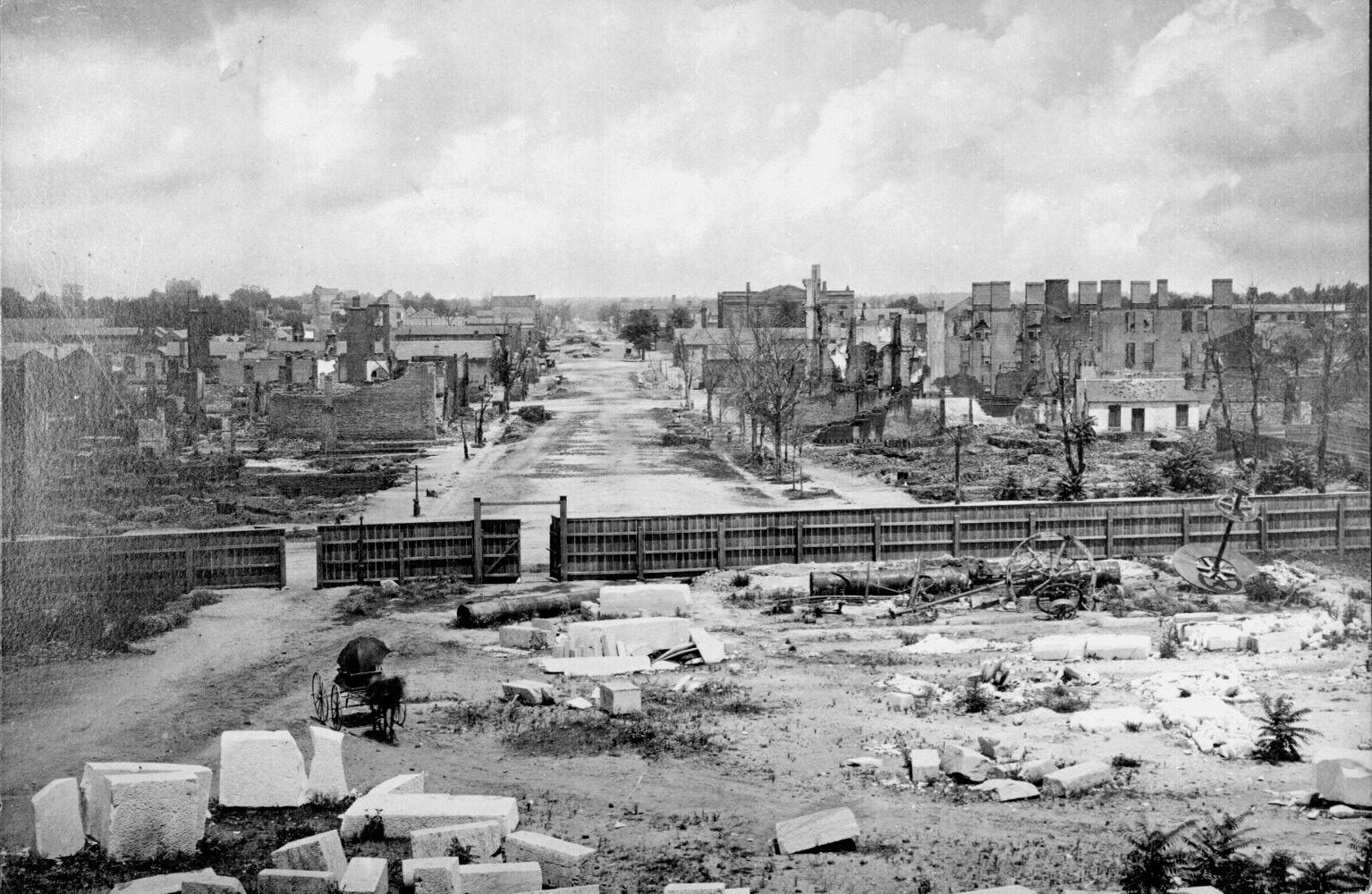
The first result was exactly what I needed--a report in the South Carolina Newspaper Project about the State House.  In that report, there's a section from the local newspaper, the Columbia Phoenix, on April 11, 1865 commenting that "When in possession the barbarians tried, in a petty manner to deface and defile as much as they could . . . They seem to have found considerable sport in their practice, with brick-bats, or fragments of rocks, as sharp-shooters; and making the fine bronze statue of Washington their mark, . . . a part of his cane has been carried away among their 'spolia opima.'" (As Jon, the Unknown, tells us, the spolia opima are rich spoils taken from the vanquished. And "brickbatted" means to hit the statue with bricks.)  Remember that the capture of Columbia was just 3 months earlier, so I'm tempted to believe the newspaper report as an accurate rendering.  

Considering the state of the State House at the time, this story seems completely plausible. 


Image from Wikimedia.  The view north from the Columbia SC State House, March 1865.
The Washington statue is near here.

And, why haven't they fixed it?  The sources seem to agree--as a continuing reminder of Sherman's troops excesses during the war.  

Search lessons:  There are several here... 

1.  There are many paths to the solution.  To figure out what the statue was, several of us used the Search-By-Image method, then followed a link or two.  But a simple search also works well. What this tells me is that when a particular method doesn't work, be sure to just move on and try another path.


2.  Not all features are on the map!  I really thought that there would be a labeled Maps feature for the statue, so I was surprised when it wasn't.  That discovery led me to... 

3.  Remember other resources on the web.  I went to Waymarking and WikiMapia and both two slightly different sets of resources, both of which were excellent. 

4.  Cross-check your answer.  As we saw, there are (at least) two different stories behind the broken cane. One of the results was a bit thin (even though it was from an ostensibly credible source).  The other had references (and images!) from original source documents of the time and was consistent with other things we knew about the situation.  


Interesting challenge!  

Keep your curiosity up, even in the face of cannonball attacks! 

Search on. 

Wednesday, March 26, 2014

Wednesday Search Challenge (4/26/14): What's the story with George's cane?

A true story:  I was traveling somewhere in the southern states when I took this picture.  It's remarkable for a couple of reasons--I can't remember where I was when I made this shot (I'm sure this never happens to you!), and I also remember that there was another statue directly in front of this one.  The problem is, since I can't remember where this shot was taken, I can't figure out what the other statue is.  


Can you help me out? This is clearly a statue of George Washington, but what else can you find out?  

Today's challenges: 

1.  Where is this statue of George Washington located?  A lat/long, street address, or building name would be enough.
2.  What happened to his cane?  Why haven't they fixed it? 
3.  What's the statue that's directly in front of George?  That is, what's behind the photographer?  


Remember to tell us HOW you found the answers.  

Search on! 


Friday, March 21, 2014

Answer: What's that thing on the horizon?

Here are the questions: 

Here are the questions I had from looking at this image... 
1.  What is that white thing labeled as #1?  Can you find a nice video of this thing close up so we can REALLY see what it is?  
2.  See that line of trees labeled #2?  What kind of trees are they?  

3.  What's the name of that big mountain at #3?   

Here's the quick answer:  

Figure 1: A higher-res photo taken from the same place (with a better camera).

Figure 2: The panorama, with Mt. Diablo labeled on the right, and an open field with
straight edge for siting guideline. (see text below) 

 How did I figure this out?  

I used a couple of different approaches. 

#1:  Look for nearby images / data that can tell you.  I knew the lat/long ( 37.365861, -122.180174 ), but it's unclear what direction this is.  By just going to Maps and dropping in the lat/long, you'll get a map like this.  Notice the pin in the bottom.  That's where the photo was taken (that's the exact lat/long).  Now, which direction is the photo?  

Figure 3: The location of the photo as shown on the Google Map.


If you zoom in a bit, you'll see this. 

At this point my first reaction would have been to use Streetview to look around.  But a quick check shows that there isn't a Streetview image here!  (Why not?  It's a private park.)  So we'll need to try something else.  How else can we figure this out?  

Let's explore the nearby images.  

If you then click on this Images tab in the lower right corner, it will open up a row of nearby images at the bottom of the Map, like this.  


If you then explore a bit by clicking on the images, the first image will be this, a Photosphere taken just a few steps away from the photo site. 


That's great!  Now we can look around and get our bearings.  

Clicking on the image brings it into the main window.  


By turning around a few times and looking at the map above, you'll figure out that our photo must have been taken by looking due north. (That's the view I'm showing here; it lines up with the original photo.)  

Now, if you go back to the main map (as shown in Figure 1), just running your finger due north from the site leads you to a few different things.  There's the Pearson-Arastradero Preserve, then Felt Lake, then the Stanford Dish. 

Okay.  What's a "Stanford Dish"?  

The obvious query: 

     [ Stanford Dish ] 

tells us that it's a big radiotelescope that was built in 1966 by the Stanford Research Institute (aka SRI). 


And, by looking at the map, it's pretty easy to see that I-280 ("The World's Most Beautiful Freeway," or so it says on the signs) is between me and the Dish.  That's what's causing the "blobby white line" in the image.  

#2: How to figure out the mountain on the right?   (Method 1: Guideline)  

There are two ways to figure this out.  The most obvious and straightforward way is to look for a clear marker that's nearby in the image that's ALSO in line with the distant image.  

If you look at Figure 3 above, you'll see that straight-edged grassy field.  Looking on the map in Figure 3, you'll see a straight-edge (a property boundary) that appears there.  Here's what it looks like in the aerial view: 

Note the guideline that follows the property boundary (it's the edge of the field where the Dish is located).
 The funny darkness in the center isn't "real," it's an artifact caused by stitching two aerial images
together taken at different times. 

Now, I just zoom out from my location, and pick up the guideline and extend it outward, looking for where it intersects with a named mountain.  I could have done this in Terrain view, but I figured a mountain this big would show up in the regular map.  And I was right--it does. First I start with my local (zoomed-in) map image. 


Then I just copy the arrow from the first image to the second (zoomed-out) map and paste it there. Note that I have NOT rotated the Map, so the heading on the arrow will be the same. 


Look carefully at the top of the arrow and you'll see the most plausible answer:  Mount Diablo.  

Of course, a quick check for images of Mount Diablo shows that this is clearly the same mountain as we see in the original image.  

BUT WAIT!  There's an even simpler way to do this.  (Caution:  This won't always work, but for large geographic features, it will.)  

#2: How to figure out the mountain on the right?   (Method 2: Google Earth clicks)  

If you click on the Earth button (lower left), you can then TILT the view downward.  (Use the Tilt button--looks like 4 little rectangles in perspective, just below the compass needle on the right.) 

A panorama taken in Earth view mode, tilted down so you can see the mountain on the horizon.

Once you're in this mode, many things become possible.  In particular, you can zoom into the mountain (use the + button on the lower right), and then CLICK on the mountain! 


#3 What about the trees? 

If you look at the above map, you'll see those trees are located in a park (the Pearson/Arastradero Open Space Preserve), using that term as a georeference is a good starting point.  For my query I did: 

     [ Arastradero preserve trees ] 

If you look around, only three kinds of trees are mentioned:  oaks (of various kinds), willows, and eucalyptus.  A quick scan through Google Images for each of these trees shows that they look like this: 


If I was to guess, I'd say these trees are eucalyptus.  

And in my clue I mentioned that "you might recognize these trees," and indeed a quick search like this: 

     [ site:searchresearch1.blogspot.com eucalyptus ] 

You'll see that I wrote  in an earlier blogpost (back in November, 2011) "In the above image you can see a long line of trees just below the lake on the left.  That's Felt Lake in the Stanford University foothills.  But those are 60 foot tall eucalyptus trees that used to mark the southern end of the old Stanford farm."  If you check, you'll see I took the image in the same place as the map shown in that earlier blog post.  

But you could also go to Streetview and check out the trees.  You'll see them from the entrance to the parking lot at Arastradero Preserve.  Compare with the above example:  those are eucalyptus.  


Lastly... the video?

I have to admit, this part was too easy... 

     [ Stanford Dish drone video ] 

done on YouTube.  It shows this really nice video shot by a drone pilot flying past the Dish, which you can now see in great and glorious high-resolution ... 


Search Lessons:  This was a classic multi-method problem.  I don't think you can solve this one just by looking on Maps alone--you have to combine information from different resources (Maps + Earth + Streetview + regular queries).  

The trick of extending the guideline along a known feature out into the rest of the map is an old trip of navigating from physical paper maps.  If you've ever spent time in the backcountry carrying around topo maps, this is a common method.  

The initial trick of figuring out the heading by looking for nearby images is an incredibly valuable tactic.  Check out nearby images of all kinds.  You can usually piece together the orientation of the images you're trying to understand.  


Search on! 


Thursday, March 20, 2014

Comment: What's that thing on the horizon?

SearchResearchers are doing pretty well.  Nice job so far. 

For readers who haven't had the chance to work on it yet, let me give you a bit of a clue. 

Here are a couple of images that I'm zoomed in for you. 


Figure 1: The image zoomed in. 

In this image you can see the "white thing" much more accurately.  You can also, in this view, see the trees a bit more clearly.  Regular readers might recognize this scene with the trees.  

Once I zzome in like this, I NOW see that white line of... something.  It's kind of lump and irregular, and I have no idea what it could be.  (Truthfully.)  Will have to check it out.  

All I did in these images was to push the scale (in this case I used Apple's Preview tool, but you can use image manipulation tool like Photoshop or Gimp).  Be careful, though, that the package you use doesn't smooth the image too much as you zoom.  You want to be able to see the actual pixels when you're zoomed way in.  

Figure 2: The image zoomed to the point of seeing the pixels.

From this angle at this zoom, it looks like a boat.  (But it's not Noah's ark; trust me on this.)  

I'm looking for a good handbook on photo interpretation that I can point everyone to, but I'm not having much luck.  The books I've been finding are all either not-available online, or were written pre-2000 (and therefore have slightly old examples and no mention of Google resources at all).  The number of available images that have come available in the past 10 years should be causing all of the photo interpretation books to be re-written!  

So if you know of any good ones, let me know.  We'll post it in the blog for everyone to learn from. 

Keep searching! 


Wednesday, March 19, 2014

Wednesday search challenge (3/19/14): What's that thing on the horizon?

YESTERDAY  I mentioned the Verification Handbook, which has a section on "Verifying Images."  The key idea of that chapter is that we all, in our role as literate online researchers, need to learn a bit about photointerpretation.  That is, we need to learn how to look for clues in an image to figure out what it is we're seeing.

That's essentially today's Search Challenge--What is it that I'm looking at?  

Here's a picture I took on my bike ride this past Monday.  I was out for a ride in the hills, and just snapped an image.  But as I looked at it later, I wondered what exactly I was seeing... 


I've included the original (unedited) image at the end of this post, so you can download it and do whatever image processing you'd like.  (Zooming in will help a bit, but it's not going to be enough to get you the unequivocal answers.)  

I'll also spare you the hassle of looking up the lat/long from the image:  I was standing at 37.365861, -122.180174 

Here are the questions I had from looking at this image... 
1.  What is that white thing labeled as #1?  Can you find a nice video of this thing close up so we can REALLY see what it is?  
2.  See that line of trees labeled #2?  What kind of trees are they?  
3.  What's the name of that big mountain at #3?   

I won't surprise you to find out that you probably can't figure all of these out just by looking at the picture.  You'll actually have to do a little triangulation to figure out what all of these things are.  Triangulate away!  

As usual, please tell let us know what the answers to #1, #2, and #3 are... but just as importantly, HOW you found the answers.  What resources did you use?  What queries worked for you?  

I'm curious to see how everyone will solve this classic photointerpretation challenge.  

Search on! 


Here's the full-size unedited image.  Right click (control-click) to download for analysis.  


Tuesday, March 18, 2014

Verification Handbook -- one you should read

Fellow SearchResearchers... 

I don't often recommend a book, but when I do, you know it's a good one.  


The Verification Handbook is a collection of short chapters about how-to-verify-social-media-information.  It's edited by Craig Silverman of the Poynter Institute (an organization you should know about) and the creator of the blog Regret the Error.  

Each chapter is a story and guidelines about how to verify the information you see flowing past on social media.  

While it's intended for professional reporters, there are a LOT of lessons in here for us in SearchResearch.  I'll be walking through some of the chapters that are especially relevant to SRS in the weeks ahead, but I wanted to give you a pointer to a book that I suspect most regular readers will find fascinating.  

The book covers the basic guidelines for ensuring that what you see is actually what's going on.  A couple of examples:  

Chapter 4, "Verifying Images," discusses getting EXIF data from an image, as well as using other corroborating information such as weather conditions (was the picture actually taken on the day claimed... did you know it was raining that day?)

This chapter includes two well-known case studies.  

Case Study 4.1: Verifying a Bizarre Beach Ball During a Storm.  (A giant beach ball appears in downtown London. Was the Tweetpic real, or fake? Answer: Real!)  

Case Study 4.2: Verifying Two Suspicious "Street Sharks" During Hurricane Sandy.  Sharks in the streets of a flooded New Jersey town.  Really?  (Answer: No.)  

There's a free PDF download of the book.  (Thanks, Poynter Institute!)  Get it.  You'll enjoy the read.  

And if you're really interested:  The Poynter Institute’s News University offers a three-hour online course entitled “Getting It Right: Accuracy and Verification in the Digital Age." Craig Silverman, the editor of Verification Handbook, examines how and why errors occur in journalism, and looks at the best ways to find facts to support your story.  www.newsu.org/courses/verification  (3 hours, $30.  I haven't taken it yet, so I can't vouch for the quality, but I suspect it's pretty good.)  

Read on!