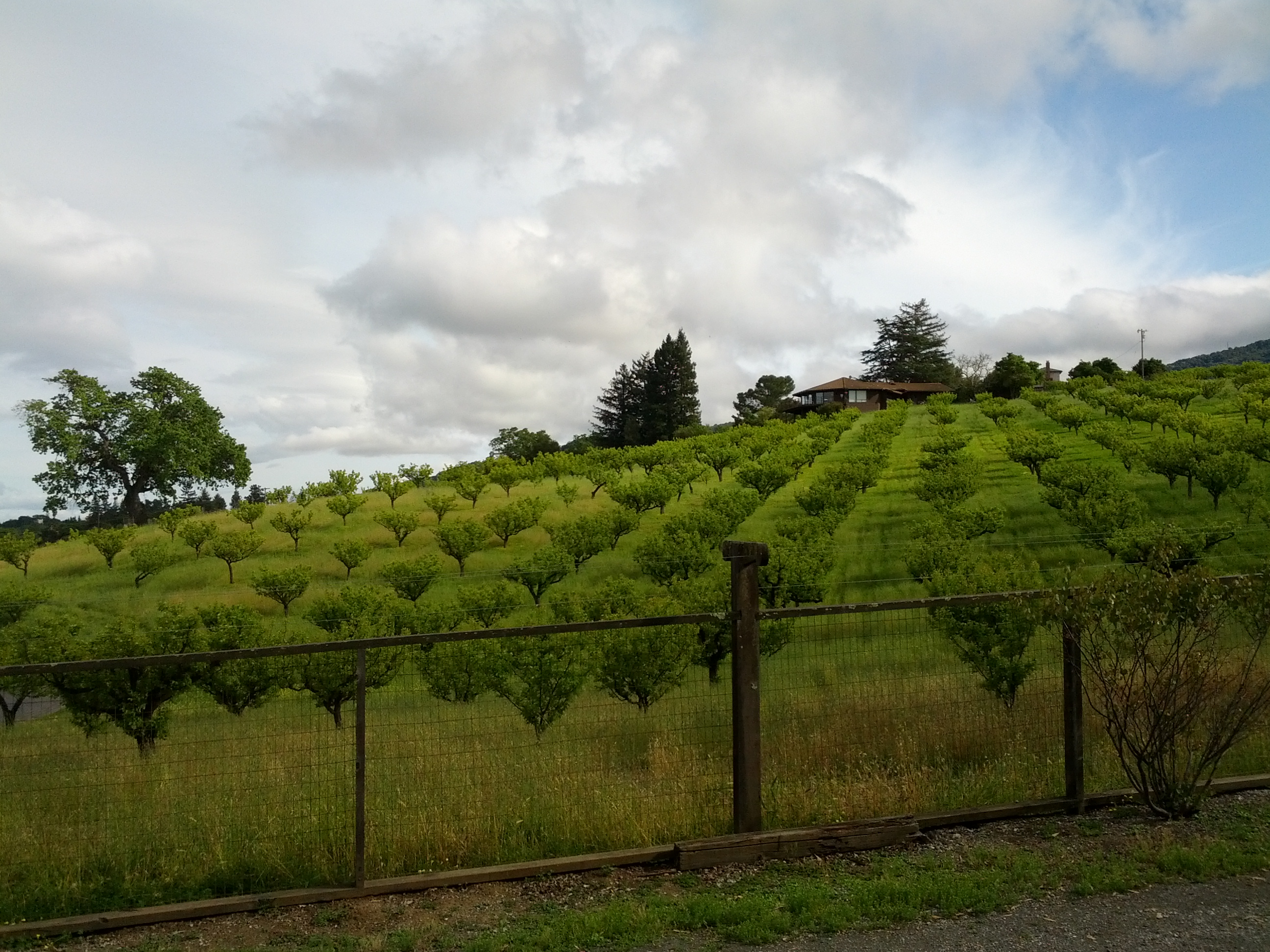
On a beautiful spring day I went for a bike ride up into the foothills of the Santa Cruz mountains, the hills that make up the western part of Silicon Valley. Up in those rolling hills lie fragmentary groves of trees, remnants of the time when Silicon Valley was called "Valley of Heart's Delight."
I paused and took the following picture. When looking at it later, I realized that I didn't know what kind of trees these were. The Valley of Heart's Delight was once home to a thriving agricultural industry, but in this particular case, I couldn't identify them through the photo.
But after about 1 minute of SearchResearch, I was able to determine a whole bunch of information about this site. Can you?

Today's questions, both of which are answerable fairly quickly... if you know how!
Search on!
(P.S. I'm travelling a bit over the next couple of days. I hope to be able to post the answer on Thursday, but don't worry if I'm offline. I'll post the answer as soon as I can find a decent wifi connection.)
I paused and took the following picture. When looking at it later, I realized that I didn't know what kind of trees these were. The Valley of Heart's Delight was once home to a thriving agricultural industry, but in this particular case, I couldn't identify them through the photo.
But after about 1 minute of SearchResearch, I was able to determine a whole bunch of information about this site. Can you?
Today's questions, both of which are answerable fairly quickly... if you know how!
1. What kind of trees are these? (No guessing. You should be able to figure this out definitively.)
2. When I took this picture, I could hear a bell ringing in the distance. Why was the bell ringing? (Hint: It wasn't from someone's house. This question is a little harder, but you should be able to find the answer.)
Search on!
(P.S. I'm travelling a bit over the next couple of days. I hope to be able to post the answer on Thursday, but don't worry if I'm offline. I'll post the answer as soon as I can find a decent wifi connection.)
Using the EXIF data from the photo I determined you were in Los Altos Hills.
ReplyDeletehttp://goo.gl/maps/r6tcm
Went into streetview and found the address [ 26580 taaffe rd ] I thought it might be a grove or orchard so I tried [ 26580 taaffe grove ] but actually got something with [ 26580 taaffe orchard ]
http://northerncaliforniagardens.sutromedia.com/packard-orchard.html
Answer 1 - Apricot trees.
Zooming out on the map my eyes were attracted to Foothill College nearby. I found mention of a bell tower in their Wikipedia entry but couldn't find any reference to hourly or daily ringing.
Backed up and searched for [ "los altos" "bells ring" ] and found mention in the results for [ Immaculate Heart Monastery of the Poor Clares ] A quick check of the map and they are near where you were.
Tried [poor clares nuns los altos bell ring mass ] and found two results for when the bells ring.
http://catholicyouth.freeservers.com/vocations/women/poor_clares/day.htm Shows more times than the other result for bells ringing.
Checking the EXIF data again for the time the picture was taken tells me it was around 4:35:18PM on April 4, 2013.
Answer 2 - 4:10 p.m. - Bell for Rosary, Vespers, meditation, collation
Took me about an hour.
nicely searched - convents in the "Valley of Heart's Delight/SV" requires cerebral flexibility - I kept trying to locate a bell - tower,clock, carillon, etc. at Foothills College that might fill the bill - even contemplated the possibility Dan was referring to the Taco Bell at 950 W El Camino Real.... but he seems more like a Del Taco kinda guy;)... maybe the Tacomania truck in MV?
Deleteperhaps it was at the PCM for the 6:25 p.m. - Bell for recreation? Tacos can be a spiritual experience of sorts. Anyway, good search & map of your process - clear & instructive - thanks. Have to go order my dried apricots now...
dried 'cots
The 1st answer is... apricot trees.
ReplyDeleteFrom the picture gps info goes to google maps and from street view i took the search info... [taaffe house 26580] there's a lot of info of that property but the better result is http://www.losaltoshills.ca.gov/documents/city_council_meetings/2009/LAH_City_Council_2009-04-23/LAHCC_20080423_AI07.pdf
The bell... well is possible that the St Luke's Chapel in the Hills located about 1Km far the apricot orchard but depends on the wind direction that day ;-)
I'm can't be absolutely sure 'cause the picture was taken thursday (4/4/13) 4:35pm and the church and the church calendar don't show any activity that day.
http://www.stlukeschapel.org/index.php?option=com_gcalendar&view=gcalendar&Itemid=24&Name=Value#year=2013&month=4&day=4&view=month
(about 10 minutes mostly looking and trying to check the bell thing)
Good day, Dr. Russell, fellow SearchResearchers
ReplyDeleteSearched
Image with text "valley of heart's delight trees "
Found: http://www.janaremy.com/ffc/author/colorado08/
Redwood trees.
Image with valley of heart's delight redwood trees
found: http://sanjoserealestatelosgatoshomes.com/silicon-valley-and-the-valley-of-hearts-delight/
Nuts.
Image Exif data: 37.3648 N, 122.146 W.
Used GPS in Maps. Found: 2637 taaffe RD
[taaffe road intext:trees]
http://wikimapia.org/10634985/Taaffe-House-Packard-Estate Apricots
[taaffe road intext:apricots]
http://northerncaliforniagardens.sutromedia.com/packard-orchard.html in: 26580 Taaffe Road, Los Altos Hills
Answer
What kind of trees are these? Apricots
Question 2, still searching.
1. apricot trees
ReplyDeleteEXIF data => Google maps => Taaffe House (Home of David Packard (deceased) of Hewlett Packard) => http://www.paloaltoonline.com/news/show_story.php?id=25975
2. Bell for meditation at Monastery of The Poor Clares of Los Altos Hills (28210 Natoma Rd Los Altos Hills) - (at approximately 1 km)
http://poorclares.wordpress.com/a-day-in-the-monastery/
Image: http://poorclares.files.wordpress.com/2008/05/driveway4.jpg
All with Google maps.
+/- 5 minutes
Wikipedia [Valley of Heart's Delight]
ReplyDeleteResult: article on Silicon Valley
http://en.wikipedia.org/wiki/Valley_of_Heart%27s_Delight
Not much of agriculture, led to “Santa Clara Valley” article
http://en.wikipedia.org/wiki/Santa_Clara_Valley
Also not much mention of agriculture, led to “American Viticultural Area” article
http://en.wikipedia.org/wiki/Santa_Clara_Valley_AVA
History section, second sentence, first paragraph:
"…by 1902 over 10,000 acres (4,047 ha) disappeared, mostly replanted to fruit trees such as prunes and apricots."
Conclusion: Probably plum trees or apricots.
Google images: [Plum Trees]
Google images: [Apricot Trees]
Review of results indicated apricots were pruned back to that conical shape and sized and spaced similar to your photo.
Conclusion: probably apricot trees
Results reviewed included:
http://sphotos-a.xx.fbcdn.net/hphotos-ash4/481753_544133635607595_791955581_n.jpg
http://sutromedia.com/published/ipad-sized-photos/403305.jpg
That second picture was a very, very lucky pick out of the image returns: it's on the California Gardens site, in their article on the Packard Orchards, in Los Altos Hills. The photos here all looked like, based on the spacing and slope, they could have been taken from that house.
Hypothesis, question 1: Picture was of a house at the Packard Orchards
Wikipedia [Los Altos Hills]
Examined article for mention of any well-known landmark houses there. Mention in the article of a house bought by Yuri Milner, but only for its price tag ($100 million), and no connection to the Packard Orchard.
Next sentence of article mentioned the Daughters of Charity of St. Vincent de Paul convent.
Hypothesis, question 2: Bells were from the convent
Google [Packard House Los Altos Hills]
First hit was the Wikipedia article on Los Altos Hills. Hits two and three mentioned the Taaffe House.
Conclusion: House is the Taaffe House
Google images [Taaffe House]
Result: no exterior shots that looked like yours
Google web [Taaffe House]
Result 1: http://social-media-lab.wikispaces.com/file/view/Taaffe+Map+and+directions.pdf
Result 2: http://wikimapia.org/10634985/Taaffe-House-Packard-Estate
Result 3: http://www.sfgate.com/bayarea/article/Paradise-Lost-Los-Altos-Hills-clings-to-its-2693101.php
Result 4: http://www.acteva.com/booking.cfm?bevaID=148632
No useful photos.
It was only at this point that I thought of looking it up in Google maps and going to street view.
Google Maps [Los Altos Hills]
Followed map from Result 3 to find Taaffe House (noted proximity of Convent while looking at map view). Switched to Street View.
Was this about where you were standing?
https://maps.google.com/maps?q=los+altos,+ca&hl=en&ll=37.364819,-122.146382&spn=0.010386,0.01929&sll=36.001827,-78.884911&sspn=0.338295,0.617294&hnear=Los+Altos,+Santa+Clara,+California&t=h&z=16&layer=c&cbll=37.364638,-122.146629&panoid=WzMhh8OoW84FfzzAheA32g&cbp=12,137.99,,0,9.94
Conclusion, answer Question 1: Apricot Trees
Addressing Hypothesis, Question 2:
Opened photo in MS Office Photo Viewer, properties, taken at 4:35pm
(My wife, a research librarian who has been following your blog for a while now, had to show me this trick)
I know the terms Matins and Vespers.
Wikipedia [Matins] resulted in article for Matins (Nighttime prayers), led to article for Canonical Hours, led to article for Vespers (Evening prayers).
Hypothesis, Question 2: Vespers at Convent
Google [Convent Santa Clara] (Researcher having temporarily forgotten the name of the convent)
First non-Wikipedia, English-language result: Poor Clare's:
http://poorclares.wordpress.com/
Daily Life section: "4:05 pm Rosary, vespers, and collation"
Supports hypothesis.
Google: [Daughters of Charity of St. Vincent de Paul]
http://www.daughters-of-charity.org/
No daily schedule.
Conclusion cannot be 100% confident, Question 2:
Vespers at the Daughters of Charity of St. Vincent de Paul
ReplyDeleteQuery - get exif metadata from image. Location 37.1211533N -122.181477 W
Maps - Taafe Road
Street View -confirmed right farm -love to ride that area. I'm still stuck inside doing virtual rides of Napa Valley. Today road Mount Veer
Query[26580 Taafe Road, Calfornia]
Result - http://northerncaliforniagardens.sutromedia.com/packard-orchard.html
#1 Answer Apricot trees.
Time 3 minutes
Query [monasteries los altos california]
Result - The Immaculate Heart of the Poor Clares
http://poorclares.wordpress.com/a-day-in-the-monastery/
Bells are at 6:25 am and 1:10 pm
The 1:10 pm bells is for None. What's None?
http://chatteringmind.com/articles/nunsinthecloister.html
The Poor Clares website didn't have an explanatiion so I found above site. It states " the nuns again repair to the Choir where they make ready to chant the hour of None (Midafternoon Prayer)." I found a couple different references (washing dishes, end of work) so changed my query to [hour of none(s)]
Result http://en.m.wikipedia.org/wiki/None_(liturgy) explains that time as the ninth hour after dawn/midafternoon prayer.
Checked time on image 4:35 pm but you could have taken pic any time. Seems reasonable conclusion that you heard these bells. Time 15 minutes.
copied url of picture and pasted into image url on Jeffrey'sExif viewer http://regex.info/exif.cgi
ReplyDeleteGot the latitude and longitude from this site 37° 21' 53.3" North, 122° 8' 47.8" West ( 37.364809, -122.146611 )and pasted that in search box in google maps. Found that site was 26737 Taaffe Rd, Los Altos, CA. Did a search on the address and found out that it was the site of Taafe House - the Packard estate. From this site http://wikimapia.org/10634985/Taaffe-House-Packard-Estate which I found just by searching the address I found out that they had apricot trees. To verify that I did another search taafe rd los altos orchards and got this result http://northerncaliforniagardens.sutromedia.com/packard-orchard.html. I found Packard Orchards and it said they grew apricots.
To find out about the bells I went back to google maps and I did another search nearby and this time searched for churches. There were 2 choices: St. Lukes Chapel in the Hills and the Poor Clare Nuns. did a search on google for <"St. Lukes..." bells> and didn't find anything. Did same search for Poor Clare Nuns and got this result http://catholicyouth.freeservers.com/vocations/women/poor_clares/day.htm
I saw that there were bells at 4:10, the picture was taken around 4:30. Depending on time zone picture may have been taken at 6:30 and the bells then were for recreation at 6:25.
Saw some people thought of a college. I didn't think of that.
Total time about 30 mins.
Searched
ReplyDelete[monasteries| churches | schools | ranch loc: Taaffe Rd, Los Altos Hills, CA 94022] in Google Maps.
And there found 3 options:
St Luke's Chapel in the Hills. Poor Clare Nuns. St. Nicholas Catholic School.
Searched in them, and now reading both Owen and RoseMary comments, not found for the moment enough data to give a correct answer. It is like Rosemary says seems reasonable that one of these options is the right one.
Ok here's another theory because I can't reconcile the time of the pic. St. Lukes is closed on Thursdays so it would need to be something special. The bells to ring from 4:05 to 4:35 would need to be a big event if it's Poor Clare Monastery. So I checked April 4 for events in the area but I haven't checked the newspapers for weddings or funerals (anyone?) But then thought what about a religious event. April 4th is Holy Thursday, the day before Good Friday. That would be a significant day and a reason to ring the bells for a longer time than usual. So I will add that to the mix.
ReplyDeleteVery Informative! This blog is great source of information which is very useful for me. Thank you very much for sharing this!
ReplyDeleteTitle Search