A blog about search, search skills, teaching search, learning how to search, learning how to use Google effectively, learning how to do research. It also covers a good deal of sensemaking and information foraging.
Wednesday, March 30, 2022
SearchResearch Challenge (3/30/22): Where is the oldest solar observatory in the Americas?
Wednesday, March 23, 2022
Answer: Finding the connections?
How is this like that?
.Seems to me that noticing how ideas, people, places, and words all link together is a fundamental to creative thought.
Last week's Challenge was an example of this kind of connective thinking, one that I hope leads you to learning how to find your own fascinating connections.
Backstory: I was walking along a trail that follows the edge of an oceanside bluff in a place that has wind and weather that always comes from the same direction. In this case, the winds always come out of the west, flows over the bluff, and then blows constantly on the trees and shrubs at the top of the cliff. As you'd expect, this causes some pretty serious deformations in the way the trees grow. The tree shown above was especially bent and pruned by the wind, as are most of the trees along this part of the coastline.
That walk led to today's Search Challenge:
1. If I want to learn more about such bent and deformed trees, what's the specialized search term that I'd want to use? (Hint: There is a very specific term to describe such trees--that's what you seek.)
Where do you start with such a Challenge? In my case, I suspected that there would be a specialized term about such trees--and as we know, if you have a precise term for something you'd like to find, it makes your search (and your corresponding learning) that much simpler.
My first search was:
[ tree bent over by wind ]
and after scrubbing through the results (and NOT finding anything useful--just lots of information about how to straighten up bent trees), I tried a more direct route:
[ word for tree bent over by wind ]
and--lo and behold--the first result was exactly what I was looking for.
2. What is the name of a musical instrument that sounds a lot like this specialized term? (Hint: The word for the instrument shares a language of origin and the first 6 letters with the tree-term. This is one of those "you'll know it when you see it" kinds of Challenges.)
Now that we know the term krummholz, I did this :
[ krummholz musical instrument ]
I'm not quite sure what I expected, but the spelling suggestion of "krummhorn" is great!
When you look up krummhorn, it's quickly clear what the connection is:
SearchResearch Lessons
Wednesday, March 16, 2022
SearchResearch Challenge (3/16/22): Finding the connections?
Finding connections...
... is a good part of what I do in my day-to-day work. As a professional researcher, I often look at data and try to figure out what this data is telling me, and how it connects to other things I know about. In particular, I try to understand how X connects (or influences) Y. That's sort of science in a nutshell--how do things connect?
Here's an example of this kind of connective thinking that occurred to me the other day.
I was walking along a trail that follows the edge of an oceanside bluff in a place that has wind and weather that always comes from the same direction. In this case, the winds always come out of the west, flows over the bluff, and then blows constantly on the trees and shrubs at the top of the cliff. As you'd expect, this causes some pretty serious deformations in the way the trees grow. The tree shown above was especially bent and pruned by the wind, as are most of the trees along this part of the coastline.
As you can see, it leans away from the wind and rain coming off the bluff (which you can barely see falling away into the sea on the far left).
While walking past this tree, I wondered today's Search Challenge:
1. If I want to learn more about such bent and deformed trees, what's the specialized search term that I'd want to use? (Hint: There is a very specific term to describe such trees--that's what you seek.)
And, as I was thinking about that term, I realized that it made a connection to a musical instrument, also made of wood, that uses the same bit of language in its name. The moment I realized this, I understood the connection! This leads to the connecting Challenge:
2. What is the name of a musical instrument that sounds a lot like this specialized term? (Hint: The word for the instrument shares a language of origin and the first 6 letters with the tree-term. This is one of those "you'll know it when you see it" kinds of Challenges.)
I don't think this is too hard, but it's fun to find connections between very different parts of one's life (in my case, a connection between botany and music).
Let us know how you did. Next week I'll talk about what I did to figure out this connection.
Search on!
Friday, March 11, 2022
Answer: What are some good (almost) real-time satellite image sources?
Seeing the Earth from space...
... is a truly remarkable ability. It literally changes your perspective. What's even better, in these days of ever-cheaper costs to fly a satellite, and the increasing capabilities of small satellites, space images are becoming easier (and cheaper) to get.
So today's Challenge is a kind of collective ask for all people who do SearchResearch:
1. What are the best resources to get time-stamped satellite images? How can an ordinary SearchResearcher get their hands on satellite images not very long after (or even during!) a major event?
When faced with a problem like this, I usually start with my "list of" trick, beginnings with a search like this:
[ list of satellite image providers ]
and sure enough, this gives a set of web pages that have long lists of potential sources (even including 4 ads at the top of the SERP pointing to commercial sources). One of the more useful results here is "15 Free Providers" with links to several satellite image services. (And, to tell the truth, I was expecting to find something like this on the results page.)
Naturally, if you've got a bunch of sources like this, my natural inclination is to organize them on a Google Spreadsheet. Not only does the sheet put everything I find into a single location, but as I read through the results, I'll find different properties of the image providers that I might want to sort or filter.
Here's that spreadsheet. Enjoy it. (And let me know if you find any errors.)
I started just by collecting the links to many different providers. Then, for each one, I explored a bit about what they offered, what they're good at, and the considerations to keep in mind.
I found that the tradeoffs are always the same: cost (you can get nearly anything if you want to pay), resolution, and timestamps.
That is, it's easy to get free low-res images without a particular time-stamp (such as by using Google Maps, Bing Maps, or Google Earth). But if you're looking for images from one specific date (especially if it's recent), then you'll need to use one of the providers that gives you fine-grain control of your imagery.
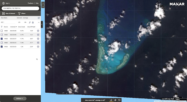
Examples: See Iroquois Reef--this place is under contention because of Chinese ships landing on/near the reef. So, how can we monitor it? One answer: Use DigitalGlobe (Maxar product) to select the image and time that matches your need:
 |
| Iroquois Reef (P/C DigitalGlobe) |
No fishing boats in sight on this Feb 27, 2022 image. But if you look around in the Spratley Islands, fishing vessels aren't hard to find. Here I used Google Earth to spot 7 fairly large ships anchored just west of Jones Reef (click on the image to see it enlarged):
 |
| Jones Reef with ships in view (P/C Google Earth) |
 |
| Brisbane Oct 27, 2021 (P/C DigitalGlobe) |
 |
| Brisbane Mar 6, 2022 (P/C DigitalGlobe) |
 |
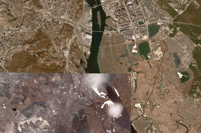
| Kiev as of Feb 26, 2022 (P/C Sentinelhub Playground) |
 |
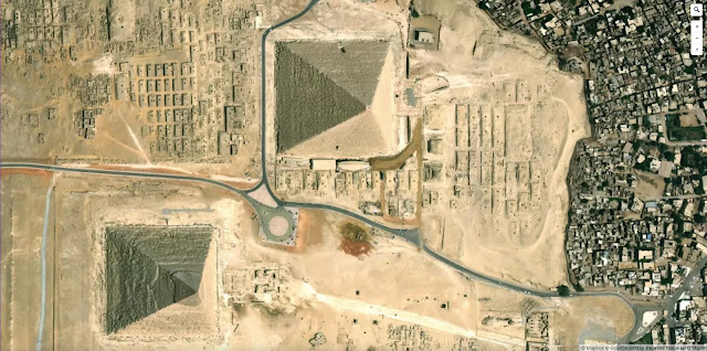
| Pyramids (P/C Google Earth on web browser) |
 |
| Pyramids (P/C Bing Maps) |
 |
| Pyramids (P/C Mapbox) |
If you look carefully, you can see differences in the buildings that are at the edge of the perimeter. These are really taken at different times, although it's hard to get an exact date from these sources. For specific times and dates, use another service, such as SentinelHub. Here's that same location, but with a date-stamp of 2022-03-09:
 |
| Pyramids (P/C SentinelHub's EO Browser) |
SearchResearch Lessons
FOOTNOTE: This post took a few extra days to write solely because there ARE so many options out there: So many things to check out! If you're just trying to do a bit of SRS on the cheap, now you know where to go. But if you're doing this professionally, be sure to look for providers that specialize in your region of interest. There are companies that do specialty services (e.g. business applications such as counting cars in a shopping mall, or doing agricultural crop health assessments), and there are companies that do speciality regions of the world (e.g., images of the coastline of North America, images over Australia, or imagery of South America). Search BEFORE doing a lot of work on your project!
Wednesday, March 2, 2022
SearchResearch Challenge (3/2/22): What are some good (almost) real-time satellite image sources?
We live in a complicated time...
... with all kinds of conflicts, disasters, and changes in the landscape of our world. There's a conflict in Ukraine, recent fires in Colorado, massive flooding in eastern Australia, and conflicts over fishing and islands in the South China Sea.
As we've seen many times before, having good aerial or satellite images can be key to understanding what's really going on. Do the news stories align with ground truth? How can you know?
And yet, a huge problem is getting your hands on current images--or at least accurately time-stamped images from the not-too-distant past in order to make sense of what's going on. Getting real-time imagery would be great, but often that's outside the budget of many non-professional searchers.
So today's Challenge is a kind of collective ask for all people who do SearchResearch:
1. What are the best resources to get time-stamped satellite images? How can an ordinary SearchResearcher get their hands on satellite images not very long after (or even during!) a major event?
And, when you give us your answer, be sure to include any little times you have about using your favorite up-to-date image source. (I've found that sometimes they can be finicky to use. Most often, the problem is in selecting the details of the kind of image you want: want cloud cover (or not)? want multi-spectral images (if so which ones)? what resolution would you prefer? etc. Give us your pro tips on using these sources!
I'll collect all of the comments and include my favorite resources. (For instance, as much as I love Google Earth and Google Maps, they're not the best places to go for current satellite images.)
And, if you have the time, let us all know HOW you found your resources.
All of our collected wisdom next week.
Search on!


