Blank spaces on maps intrigue me,
 |
| What was once here? |
.. as do blank spaces on the land. More than a few SRS Challenges have centered on attempting to find out what happened here--this week's is in that category--what happened here?
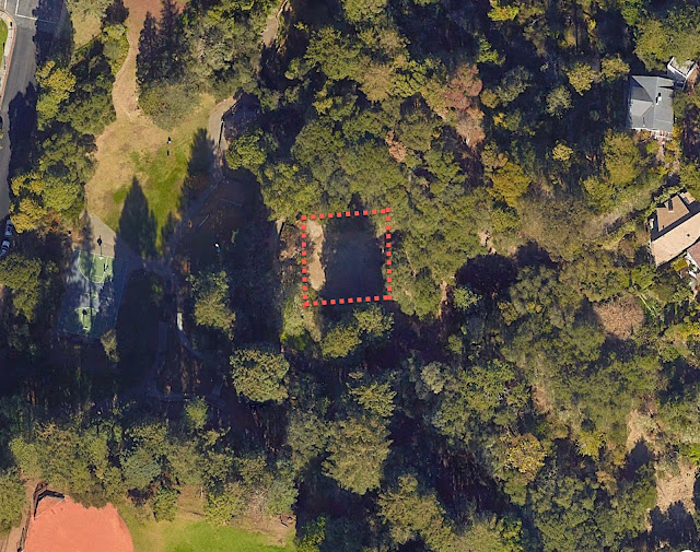
In this case, I was walking through a local park and happened upon an area (see the image above) at 37.885832, -122.261408 that was fairly blank. Since it was on an otherwise hilly area, it looked very much as if a building had been there at one time. There were a few pieces of flat concrete that looked suspiciously like former building foundations, and even more mysteriously, there's a flagpole on the western edge of the flat spot.
Well... huh. What's up? After a bit of SRS I found the answer AND another interesting story about the place. This leads to today's Challenges:
1. What was once at 37.885832, -122.261408? Can you figure out the story given just that lat/long and a keen desire to figure out the past? Was there a building there? If so, who built it and why?
2. The architect that that building is also the architect of a few other pieces nearby. Can you figure one that's closest to this spot?
As I mentioned last time, I'm deep in the middle of running my class at Stanford, so I'm going to keep the SRS Challenges on the interesting/fun but not-difficult side for the next 2 months. Hope you enjoy these just as much!
Search on!
a stumbling, bumbling search on my part… luckily, there were roses to smell…
ReplyDeletehas a photo of the 'clubhouse site' & the flag pole - clubhouse supposedly survived into the '70s - comments are interesting
'American architect in the Arts and Crafts Movement of the early 20th century. He was an instructor at University of California, Berkeley.'
example
also a contender…
about 3/4 of a mile away…
Captain John Slater House
Redfin - This home last sold for $1,505,000 on Feb 28, 2008
rose garden
Remmij, with [codornices park name change] , found:
DeleteThese rock parks have an important place in climbing history: Yosemite and WW II
https://www.bpfp.org/index.php/bpfp-official-documents/a-short-partial-history-of-berkeley-parks/
some additional…
ReplyDelete5 houses in SF
Bernard Maybeck
has link to index
Berkeley
2711 Buena Vista Way
This one took me a bit longer as I chased after lots of red herrings before finding the answer. First I started looking at the street names / trail names and searching for things connected e.g. Tamalpais / Quail Trail, etc. (I'd never heard of Mt Tamalpais - so thought this may be a name). I quickly came up with Bernard Maybeck as a possible architect. I tried searching for Quail Trail, and the Rose Garden and similar to little joy but did come up with something called the Hillside Club that had a club house and a fire in 1923 (https://en.wikipedia.org/wiki/1923_Berkeley,_California_fire). This destroyed a Hillside Clubhouse but I think it was elsewhere (although not certain - didn't confirm). http://www.fivecreeks.org/projects/codornices_creek/WalkCodforWEbSite.pdf
ReplyDeleteHowever things didn't quite fit - I couldn't add everything up. Eventually I found that the park was called Codornices Park (or Creek) and that there was a club house there that had now gone. But the Wikipedia article on this didn't mention the fire. I then tried "Condornices Park" History. Plus I looked at the map and the panorama images - that included the flag pole.
Eventually I found gold. I wanted to see if there was anything on the club house so searched for ""Codornices Park" "club house" and this gave images. So I looked at the images and found http://quirkyberkeley.com/the-codornices-club-clubhouse/ with both a history and pictures of the club house and what happened to it - it continued to exist to the 1970s (so nothing to do with the fire). The quirkyberkeley.com site describes the building including the flagpole - which was built in 1916 by the Codornices Club.
Next was to find other Maybeck buildings. Some are listed at https://en.wikipedia.org/wiki/Bernard_Maybeck. The one that seems the closest is Rose Walk (1912) — public outdoor stairway and landscape although 1537 Euclid Ave, Berkeley is also pretty close.
Couldn't resist answering this one, although it was an easy get since I spent summers sliding down the Codornices slide as a kid (I still call it Cordonices). I went directly to the map to confirm the location, did a search for Codornices Park history, and after a few dead ends refined it to the slide history and came up with the link that gives the answer: http://quirkyberkeley.com/the-codornices-club-clubhouse/ Thanks for suggesting the search! - fun to learn something about my former home town.
ReplyDeleteAfter reading the already posted answers, tried to find how the Club House and the park were. Searched for videos with past dates and similar.
DeleteJust found this video from 10 years ago with two ladies enjoying the slide as Naomi said.
This is how you remember it, Naomi?
https://youtu.be/3vZfe6ZjmFI
We would sit on waxed paper to make it really fast! I think they've banned that now.
DeleteI can see it now... late night illegal waxed paper runs on the concrete slide! Those evil kids!!!
DeleteWith [ Codornices park name change]
Deletehttps://www.bpfp.org/index.php/bpfp-official-documents/a-short-partial-history-of-berkeley-parks/
Ctrl- F Codornices: "These rock parks have an important place in climbing history..." Yosemite and WW II
Another tour to Codornices Park. Video (2020) and history (
DeleteFrancis Violich)
https://www.everydaywithjill.com/amp/a-tour-of-berkeley-s-codornices-park
'concrete' evidence/overview - has videos/concrete slide
ReplyDeleteHello everyone
ReplyDeleteI began by pasting the coordinates into Google Maps to find the location. Then tried Google Earth Web version for historical imagery, but historical imagery is only supported on the downloaded version.
Switched to looking for the historical society for Berkeley and their resources.
Berkeley Historical Society Resources
That gave me this page Other Online Resources on Berkeley History
Scanning that page I was attracted to Quirky Berkley as this was in the description "See especially the "Gone" category in the right sidebar menu."
Quirky Berkeley - Gone
I didn't see anything jump out at me, so tried using their search for [ codornices ]
Bingo! They have an article about the clubhouse that was once just above the concrete slide The Codornices Club Clubhouse
Finding the name Bernard Maybeck, I did a search for [list of bernard maybeck houses in berkeley]
First on the Search Engine Results Page (SERP) was a list with addresses from Noehill Noehill:Architects Bernard Maybeck (1862-1957)
Can I use Google Sheets to calculate the distance from Codornices Park? Search [google sheets calculate distance between two addresses]
Google Maps Formulas for Google Sheets
I used a copy of his sheet. Copied the data from Noehill. Then cleaned up the data to create this sheet.
Bernard Maybeck buildings Distance from Codornices Park
From that I think there are two that are within a quarter mile of the park.
This is a wonderful solution. Many thanks for setting up that very clever spreadsheet. I'll definitely point people to it when I write up the answer next week. Nicely done.
Deletecourtesy of Arthur Weiss's map
DeleteUC Berkeley
with the addresses you can use the measure distance tool in maps…
Thanks @Arthur Weiss. Nicely done. Great reminder about the Google MyMaps as a tool for seeing this.
Delete…speaking of blank spaces —_—
ReplyDeletewandering/wondering in the blank space…
Information Processing Theory
What is Document AI?
between my ears
memory & space
'The Space between Our Ears: How the Brain Represents Visual Space'
one way to process 'space'
an Amazonian approach
wiki
perhaps Dan is a 'Swiftee?'
blank space for mathlady
New(or Old)ton
V-E+F=2
special wiki
'In map layout, negative space, also called white space, is the "empty" space in a map that does not contain map symbols, text, or other elements.'
With [list of Bernard Maybeck buildings Berkeley in a map]
ReplyDeleteMap of buildings designed by Bernard Maybeck. (On Google Maps)
Curious that zooming looks clearer to me than when clicking on Dr Russell link. I don't understand why. I'm sure I am doing something wrong as both maps are the same
https://noehill.com/architects/maybeck/map.asp
won't go away… & scary as a honey badger… boooo
ReplyDeleteit is Halloween, in Berkeley, near Codornices Park - Glendale La Loma Park - 2022
why nature sooooo scary?
You have definitely identified a blank space in my brain.
DeleteI too arrived at http://quirkyberkeley.com/the-codornices-club-clubhouse/
ReplyDeletehttp://quirkyberkeley.com/the-codornices-club-clubhouse/
The Codornices Park, one of the first parks in Berkeley, was opened in 1915 with a magnificent field house
In 1913, a group of neighbors formed the Codornices Club and developed the park. The east side of the trestle/Euclid Avenue was developed first. In 1913, a group of neighbors formed the Codornices Club and developed the park. The Club presented plays, concerts, dramatic readings, and dramatic recitations.. .
Martin St.John remembers this about the floor plan:
The entrance to the building was at the head of the stairs now leading to the cement slide. Continue up the steps you will pass a flagpole on your left
Well – instead of building up to the best photo in this post, I opened with it. It shows the long-demolished Codornices Club clubhouse, on the top of the eastern hill above the start of the concrete slide. Once upon a time, Codornices Park was Codornices Canyon. The full name of the canyon was El Valle de Los Codornices, named by Don Jose Domingo Peralta in the 1840s “Codornices” is Spanish for quail.
Maybeck is the famous architect but my time is done and my bum is sore from sliding down the concrete slide.
Good one. j
This comment has been removed by the author.
ReplyDeletefwiw jon - burlap & wax paper
ReplyDeletedo blank spaces exist?… does dark matter? does matter matter? does Wossamotta U?
Rock & Bull
a list of places obscured, but not really blank - the reasons vary…
a sRs favorite
the initial challenge…
Boötes Void
not blank, but odd map spots
via Maps
German goo
'Eel’s blood contains a toxic protein that cramps muscles, including the heart. In other words, eel’s blood can kill. Never eat raw eel.'
Nature eel datasets
of interest – while wandering in the past
ReplyDeleteon the map front from almost 2 years ago…
Good point. I remember that day (I knew Michael from Google). Brilliant guy.
Delete