Thursday, July 3, 2014

SmartyPins: a new Google game to teach about Google maps (and a bit of geography)

Google just launched a new game--SmartyPins--that lets you answer geographic trivia questions by dropping a map pin on the right place.  

The game comes from the Google Maps team and is intended to highlight both the scope of Google Maps (namely, worldwide and high resolution), and the 

SmartyPins is currently featuring questions about the WorldCup, but it also has a "regular" trivia questions section.  

It asks a question, then you drop a pin on the place in the world where the geographic feature is located.  


This one's not too hard, but some of the questions get a bit more sophisticated.  

It's a bit like AGoogleADay.com, but with a very slick (and beautiful) Maps interface.  

Kudos to the folks on Maps team that produced this.  (In truth, I wish I'd done this!)  

Teachers & Librarians:  I can imagine a few uses of this.  Can't you? 


Search on!  Geographically! 


Wednesday, July 2, 2014

Wednesday Search Challenge (7/2/14): Why could I run on water?

Here's a fun Search Challenge for the first week of July.  

After I went to the IRE conference, I had a nice run from the middle of the park to the edge of the Pacific Ocean.  Oddly, though, I seem to have acquired the ability to run on water!  This surprised me a bit when I got my running track as plotted my Android device.  


See that bit of red line that extends into the water?  Interesting, eh?  Trust me, I can run reasonably fast, but not on water.  (Yet.)  

This little map represents my run.  It took me about 38 minutes to run this loop out and back.  

Because this quantified self wants to know, I'm turning these key questions over to you.  Can you help me figure out what happened here? 

1.  How is it possible that, while running on the beach, I seem to have run on the water?  What is a non-supernatural explanation for this? 
2.  What was my speed while running this course?  (In either kph or mph, I'm happy with either.)  
3.  While running in the park I noticed that the ground I was running on was not quite what I expected.  What kind of ground was I running on? 
4.  (Extra credit)  Here's a picture of something I ran past at the end of Lincoln Way, just off the end of the road.  What is it?  (No, I know what the windmill is.  What I'd like to figure out is what's the blocky thing with all of the graffiti on it.  What's that?  Although the story behind why there's a windmill at this particular location is interesting as well.)  


As always, be sure to tell us HOW you found the answers to these questions!  

My answers on Friday, July 4th.  


Tuesday, July 1, 2014

Answer: What do these cameras do?

After the all of the hubbub of the IRE conference quieted down, I turned my attention to answering our question from this week, which is, after all, a kind of investigative bit of reporting.   

As I said, when I posted this Challenge, I didn't know the answer.  After more hours than I care to admit, I think I have the answer... or at least part of it.  I'm sure I'll keep poking around on this one over the next couple of weeks, trying to nail down the details.  

The Challenge was, given a few pictures:  


   1.  What are these cameras doing? 

   2.  Who owns (or installed) the cameras?  

   3.  What happens to the images being captured by the cameras?  


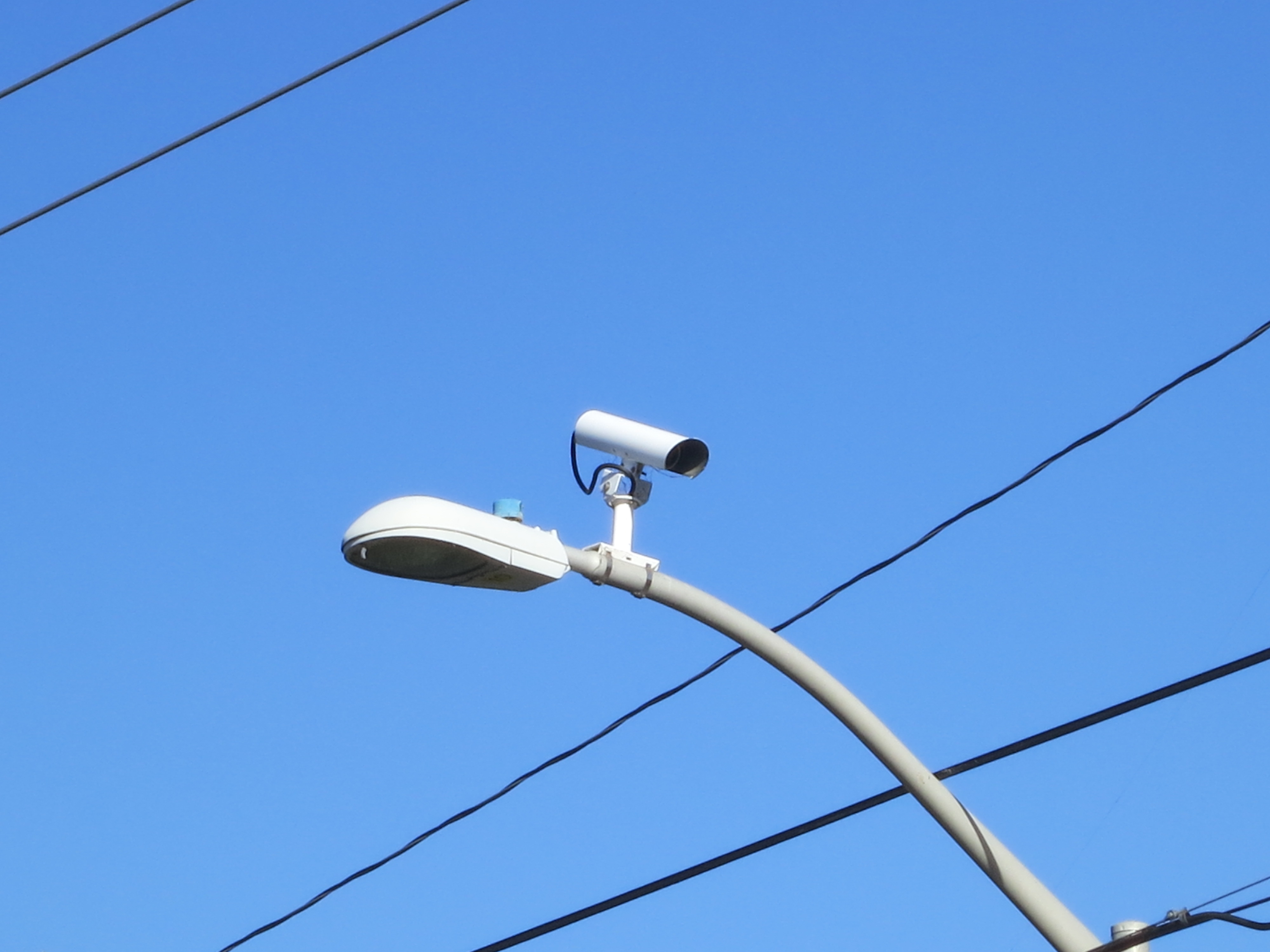
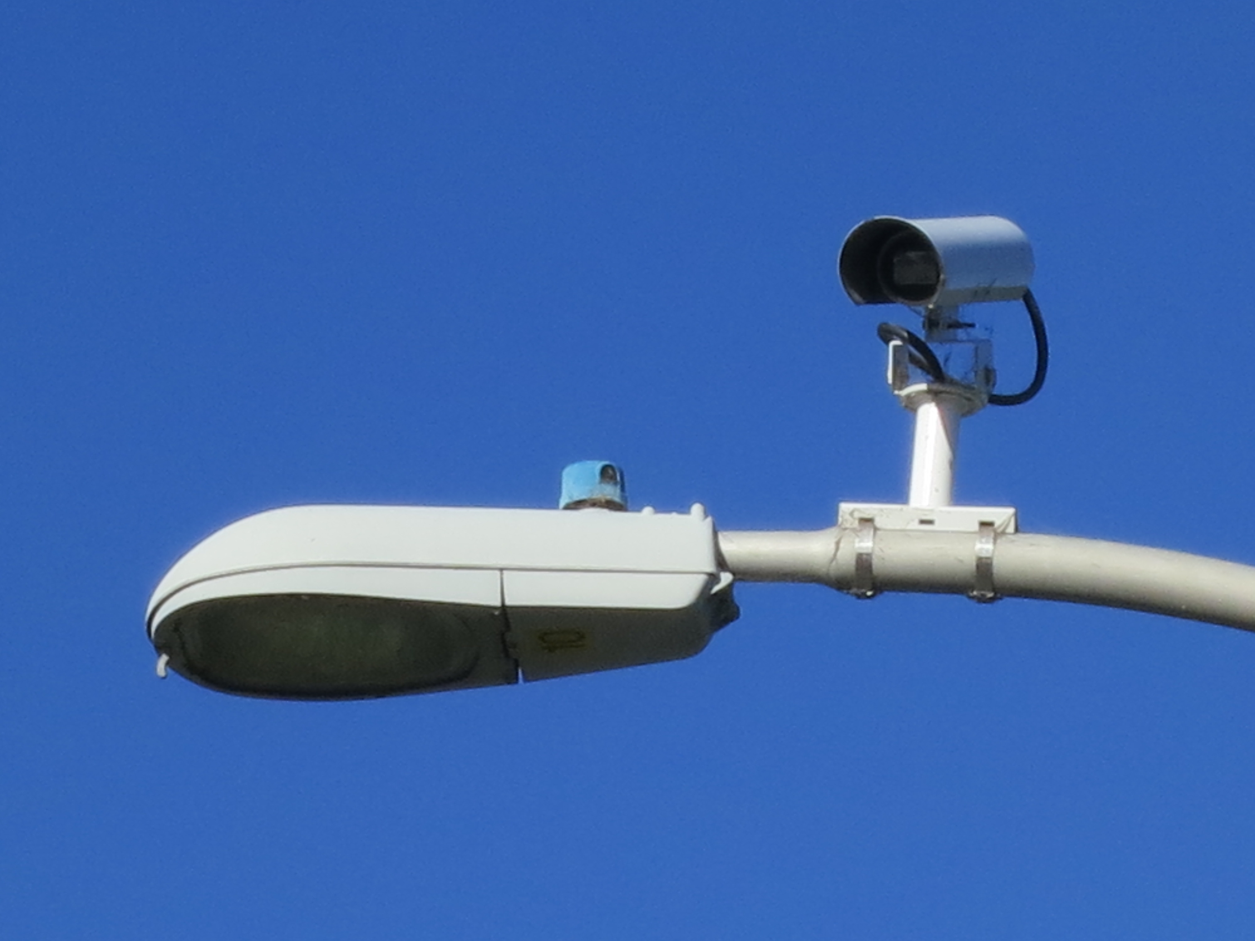
To remind you, here's the camera we seek.  They're mounted on top of streetlights at intersections, one pointing each way.   


I started this search by doing a bunch of obvious searches: 

     [ Palo Alto traffic camera ] 

     [ Palo Alto street camera ] 

and so forth.  

I learned a good deal, but didn't get anything definitively.  

Like many readers, I found the current "Bicycle camera monitoring" controversy.  But if you look for the pictures associated with the "bicycle cameras," you'll see they look very different.  

Image from Palo Alto Online (May 16, 2014).

As you can see, these cameras are a temporary fixture: they're on top of poles that are chained to telephone poles.  It's a self-contained unit--there's no video cable leading out to some higher authority.  (Apparently the video is put onto a DVR in the red box, which is then examined by humans later to track bikes and pedestrians.  The data is then deleted, according to the City.  Palo Alto Online article.)  

That's not what we seek. So that's a dead end.  

I tried various other combinations:  [ white streetlight camera ]  [ cylindrical traffic camera ] and had little luck.  

I changed my query to: 

     [ Palo Alto streetlight camera ] 

and in result #1 I found this: PhotoEnforced.com (which seems to be a crowd sourced database of camera enforced locations.  Begun in 2001, the open database of red light cameras and speed cameras (and fines) is continually updated by users from around the U.S. 

But this shows only 1 camera, and that's in East Palo Alto (which is a separate city from Palo Alto).  Another dead end.  

It seems that these cameras aren't "red light" cameras (those tend to have multiple lenses and a flash), and they're not speed cameras (which have a different shape).   See this Trapster article for a nice way to tell them apart. See also this article on Digital-Camera-Pictures blog. 

I was able to find similar cameras by doing an Image search for: 

     [ traffic surveillance camera ] 

In the process of reading about these cameras, I picked up the phrase "traffic surveillance," that seems to be what these cameras are called. (I think I picked it up from the Trapster article linked above.)  

Time to change strategies.  

One well known place for clues about hot-button topics like this is the local newspaper.  I started checking them: the Palo Alto Post, and the Palo Alto Weekly are the two big newspapers in town. (Well, there is a 3rd newspaper--the "Daily News," but you can't search them via Google as they prevent the Google spiders from indexing their content and their own search engine seems broken.)  

So let's check the local news:  

     [ site:paloaltoonline.com  traffic camera ]

Found this article which asks "So what are those camera atop the streetlights on Arastradero?"  (Great question!  I swear I didn't know about this article before writing up the Search Challenge.)  

The article actually doesn't say much.  BUT the online reader comments DO!  (And this is why you skim the reader comments.) 

One letter-writer points out that the Santa Clara County has its own traffic cameras.  The reader helpfully provided the link, but it was a dead link.  But that gave me enough of a hint to search for 

     [ site:www.sccgov.org traffic camera ]  

(www.sccgov.org is the site of the Santa Clara County)

The first hit looked like what I wanted:  "View Real-Time County Traffic Cameras

And within a few clicks I was able to see the live map of cameras that the County runs.  Here it is, live traffic monitoring!  


I'd thought I'd tracked it down.  BUT NO!  This is not what I'm seeking! 

First, the map above doesn't show the street intersections I was curious about (Charleston and Nelson, for example).   When I look at the mapped intersections using Streetview, I find that these are SQUARE cameras, not cylindrical.  It's a different kind of camera.  

By this point I'd spent several hours looking through various resources.  And while I'm happy doing that, it seemed as though I was missing something obvious. 

So I looked up the phone number of the Traffic Department for the city and gave them a call. 

Obvious, right? 

I left a message, in just a couple of hours, one of the folks from the City of Palo Alto Traffic Department called me back.  

In our conversation he confirmed that the "white cylindrical cameras on the streetlights" were "traffic monitoring cameras" that are used to trigger light changes.  That is, they're currently used to watch the box opposite the traffic light and then switch the light (a task that was previously done by in-the-asphalt ground loops).  

When I asked "but I see the maintenance guys still fixing the loops at these intersections," he replied that they're still used for redundancy.  

"What happens to the video?" I asked.  "It's written to memory at the curbside box," he said, "but it's not transmitted anywhere else." 

"Really?" 

"Yeah, really."  He paused.  "Although if we ever get them connected to our fiber network, we'll be able to monitor those intersections in real-time."  

So there you have it.  The official word from the City itself.  With only a tiny hedge about what's possible in the future.  

Search Lessons:  

The obvious lesson here really is the most obvious--sometimes it's faster just to call the City and ask.  

Second, there are still some things that are hard to find.  You'd think, in these days of goverment transparency, that something like a "map of the traffic cameras" would be on the city's website, but that apparently isn't the case.  


Skeptical Dan
Third, as you do your investigation you have to keep checking... in my case, I found many dead ends and things that LOOK like success (the bicycle cameras, for instance), only to discover that they weren't really what I was looking for.  

A useful attitude to keep in mind is one of supreme skepticism.  If it helps, imagine that you're going to show your newly discovered result to your teacher and explain why you believe this is the right answer.  

Imagine, if you will, trying to explain what you found to this guy on the right...


Commentary: 

I was impressed by the quality of the searching done by the SearchResearchers.  

Like Fred, I found the West Sacramento page ("What are those gizmos?") in an early search, but I wanted to get deeper into the story, so I kept looking. 

Jodimillard also found the SCC camera site, but correctly noticed that it wasn't what we were seeking.  

However... Unlike Ramón, I did NOT find the City of Palo Alto Request For Quotation for the video camera installation.  He did.  That's a great find.  (But we need to remember that the cameras have been installed since at least 2004.  This RFQ is for 2011, and the work wouldn't get done until much later. 

Nevertheless, the RFQ asks for the installation of the "Vantage RZ4-AWDR color camera," which you can look up to find the manufacturer specs, and a picture of the camera.  


which is just what we were looking for.  

When I read the RFQ carefully I found this interesting phrase:  


6.1.8  The interface unit shall support streaming video technology using MPEG4 and H.264  standards to allow the user to monitor video detection imagery over the Ethernet  interface. Motion JPEG streaming video shall not be allowed.
6.1.10  The user shall be able to select a quad view of all of the four cameras simultaneously  on the output video monitor by depressing the menu button. 

Which means that the Traffic guy from the city was absolutely correct.  The cameras CAN be used for remote monitoring one at a time, or all 4 together.  (And, of course, remote video capture, although that's not mentioned in the RFQ, but it would be easy enough to setup.)  The max resolution of the video is 720 X 486 (D1 resolution), which might barely be enough to capture license plates.  Maybe.  

Based on this information I did a search for

     [ site:cityofpaloalto.org "video detection" ] 

and found that the contract (for $79K) was awarded to Iteris (the maker of the detection system) on June 1, 2011.  I assume that those cameras were added sometime after that.  

Now, if I could only find that room buried deep within City Hall that monitors all of the (hypothetical) traffic cameras.  


Search on! 


Monday, June 30, 2014

Where's Dan? What happened to last week's answer?

No, I didn't just fall off the face of the earth, and no, the secret cabal that is installing traffic cameras didn't get me in the middle of the night.  

The explanation is much simpler:  I got busy.  

The details are interesting, though.  

As regular readers might remember, each year in late June I attend the "Investigative Reporters and Editors" conference.  This year it was in San Francisco, so it was nearby.  I had to go!  

But Monday through Thursday I was at a different conference, which set me back (in terms of getting my work done), so I had to prep for my IRE talk.  

The good news is that the talk went very well.  My room held around 200 people, and it was standing-room only (with more than a few people sitting on the floor).  


Dan teaching SearchResearch methods at IRE 2014. (Photo by Erik Palm from about halfway back.)

I'll write up the answer today, but wanted to give you a link to the TipSheet that I wrote up for the IRE seminar attendees.  

IRE 2014 TipSheet includes links to last year's TipSheet, an outline of the seminar, a link to the slides, a link to the full list of Google operators, and a few other things you might be interested to see.  We've covered many of them here in the blog... but not all.  

(In the meantime, I'm waiting for a callback from the City of Palo Alto Transportation Department for an authoritative answer about those cameras.)  

An answer in just a bit... 


Wednesday, June 25, 2014

Wednesday Search Challenge (6/25/14): What do these cameras do?

If you're like me, you'll sometimes notice something in your environment and wonder, "What's that?"  

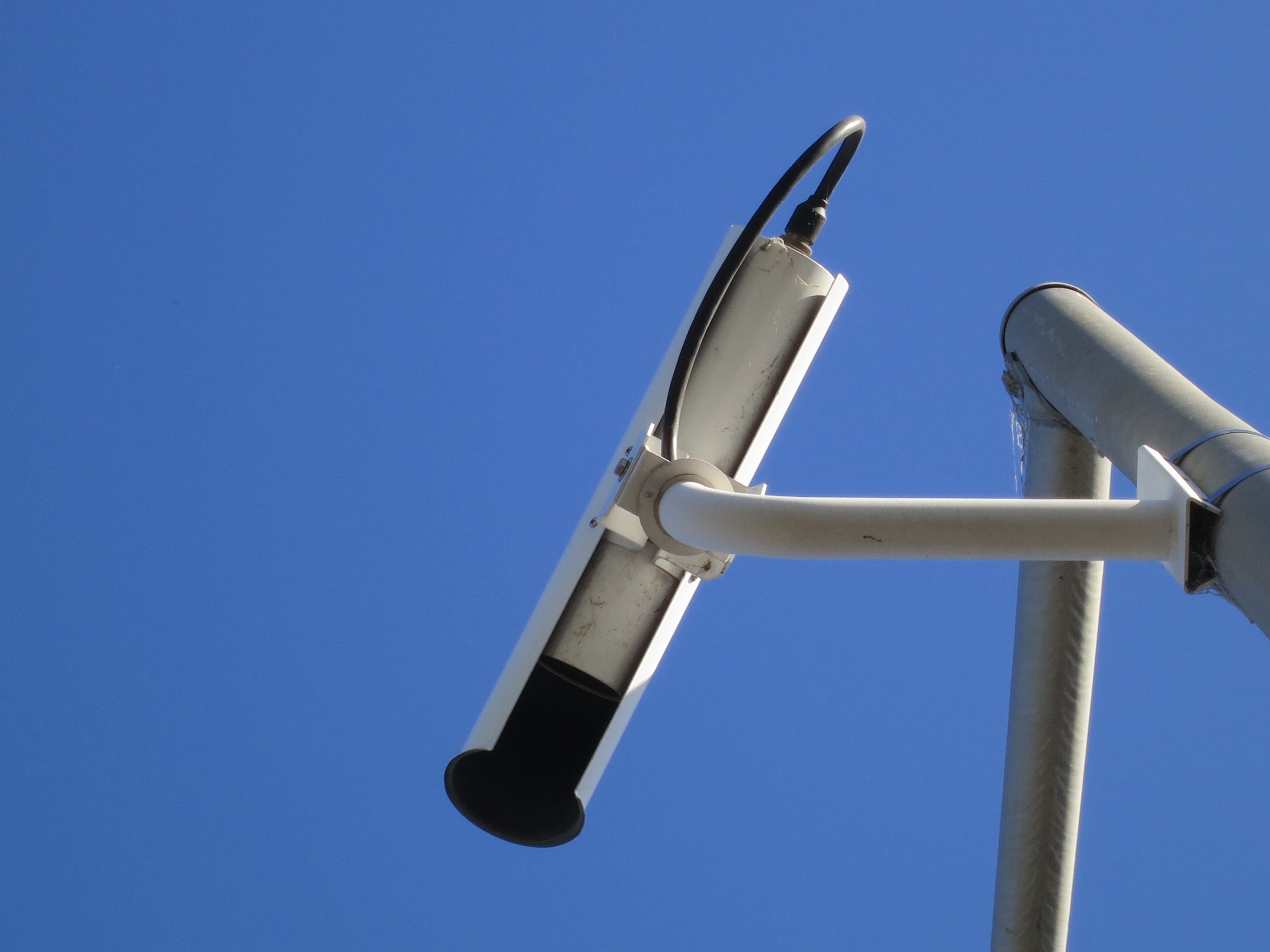
Recently I noticed a bunch of unmarked cameras on top of light poles at traffic intersections near where I live.  Suddenly, it seemed, every intersection with a traffic light suddenly sprouted a camera that was pointed at each lane of traffic.  A three-way intersection has three cameras, a regular four-way intersection has four cameras, and so on.  (To be honest, when I check archival Streetview images, I see they've been there for at least 7 years, so this isn't a new thing.  But I JUST now noticed them.  And when I ask people about the cameras, 9-out-of-10 people say "what cameras"?)  

Initially I thought these were for visual traffic detection, something to replace the big loops of wire that detect when a car pulls up to the stop line.  But that didn't seem to make sense because I saw maintenance folks still fixing the loops.  

I did a little poking around, and it seems pretty clear that these are not red-light violation detection cameras.  (Or if they are, nobody seems to be getting tickets, and it's a huge waste of money!)  

So the question is, what are they?  That's today's Challenge.  And I have to tell you that I do NOT know the definitive answer to this Challenge.  (I think I have a good idea based on my searches this week, but I'm not 100% sure.  We'll work this one out together.)  

   1.  What are these cameras doing? 

   2.  Who owns (or installed) the cameras?  

   3.  What happens to the images being captured by the cameras?  


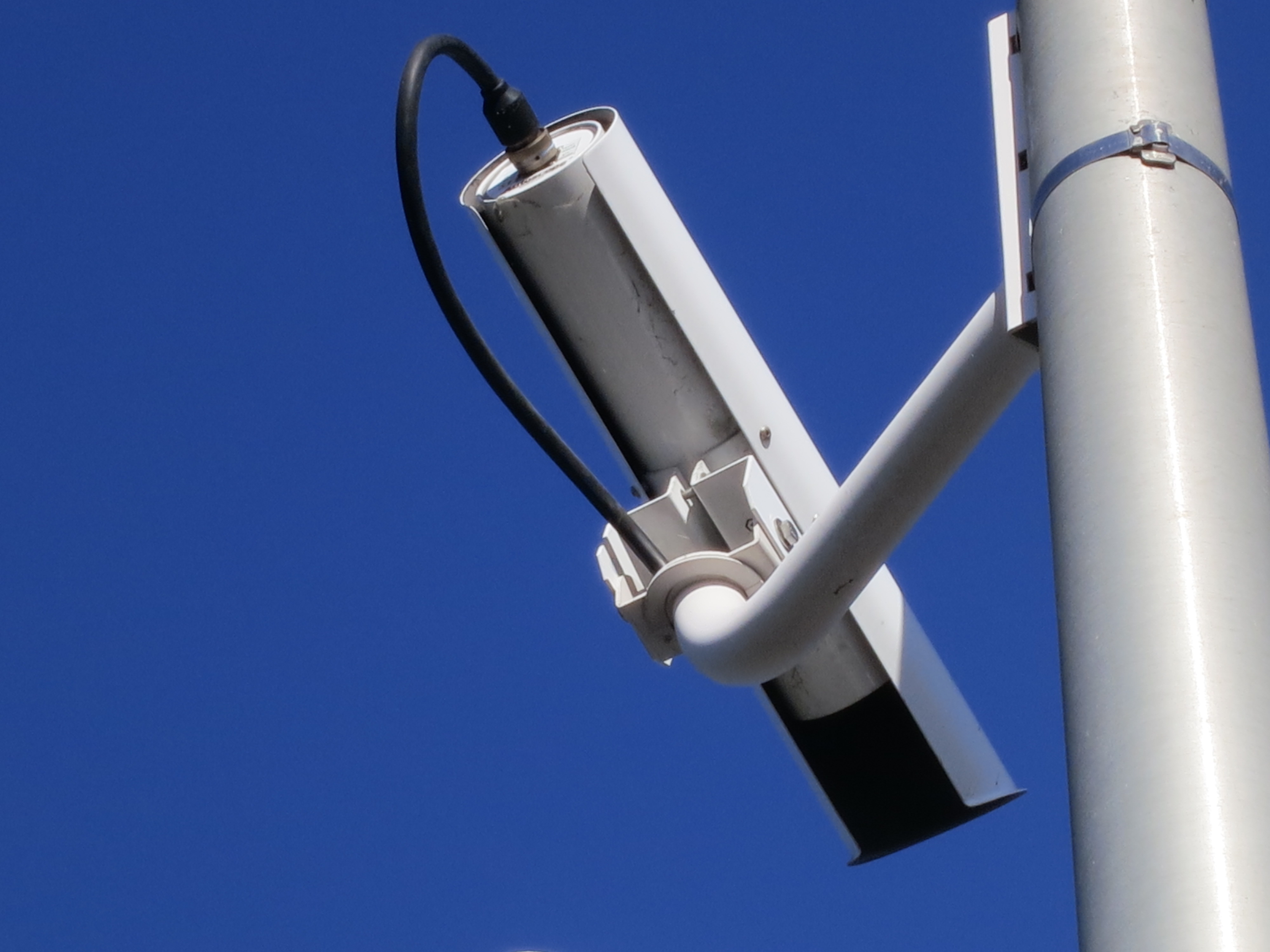
Here are 4 fairly high-quality images that I took just last week.  From this information, can you figure out the answers to the Challenge questions?   (You can click on these images to get the full resolution original file.)  


As you can see, there are few (or none?) identifying marks on the cameras.  No brand names, no part numbers that I can see... not much to go on.  This strikes me as odd in-and-of-itself.  The pole is marked; the light fixture is marked; there are part numbers on everything... except the cameras.

To save you the trouble of looking up the EXIF data, these are at the corner of Charleston and Nelson Drive in Palo Alto, CA.  (Lat/long:  37.4192351, -122.1115148)  But they're the same at essentially every intersection.  

Here are a bunch of images from Streetview of nearby intersections. 


It strikes me as odd that this major infrastructure deployment (cameras on EVERY streetlight) was done without any obvious announcement to the public.  Of course, it's possible that I missed the news item, but this seems fairly... well... odd. 

Can we figure out what these cameras are doing?  

Search on, Search Researchers!  


Friday, June 20, 2014

Answer: Can you see to the other side of this mystery building?


This week's challenge was semi-hard: 
1.  Where is this building?  (A street address or lat/long would be a fine answer.) 
2.  With your extraordinary SearchResearch powers, can you find a picture of the OTHER side of this building?  (Trust me, it's worth a look.) 
3.  How old are those trees on the left side of the building?  (Within a couple of years is fine.  But you have to tell us why you believe that's the correct date.) 
4. (Extra credit for the truly hard core searchers, and because you know I enjoy knowing the history of a place...)  What was located on this site in 1875?  


Here's what I did.  

First, start with the original photo,  then crop it down to just the big, white logo: 


Even though this is small, a Search-by-Image will tell you that this is, The Sea Ranch Lodge, 60 Sea Walk Drive, P.O. Box 44, The Sea Ranch.  As Debbie G found out, sometimes you might have to play around a little with the cropping to get it "just right."  But I've had good luck in the past by just cropping it tightly so that just the logo (or relevant symbol) is showing.  


Once you know the street address, you'd think that you might be able to use StreetView to get a look at the building--but no, that particular stretch of Highway 1 is removed from StreetView, so we'll have to do something else.

Simplest way:  Search for photos or photospheres near that location.

There are multiple different approaches:

1. Using StreetView:

Search for [ The Sea Ranch Lodge ] this gives you a map like this.  The red balloon is the location of the Lodge.  (This place is 30 miles north of Jenner and about 8 miles south of the mighty town of Gualala. The place is pronouned "wah-la-la."  Really.)

Now, to look for images taken near here, you can click on the upward pointing arrows in the bottom right--but first, let's check for any photospheres taken near this location by clicking on the Pegman (he's usually yellow, but this was shot during 2014 World Cup, so he's a soccer/football guy in this image).  


Once you do that, you can see the blue dot (just above the red balloon).  That blue dot is a photosphere.  


Clicking on the photosphere lets us look around.  Note that you can zoom in/out and by dragging the image, you can spin the point-of-view.  

(And as you might notice, the photosphere is ACTUALLY on the small peninsula labeled "Black Point" in the above map; the dot location is incorrect on the map.) 

LESSON:  It's sometimes worth checking around a site--people still mislabel, misfile, & misplace things. Here it is, the Lodge from the other side... It's a pretty spectacular location.  


2.  Using Maps Views search to locate photospheres:

It turns out that Google Maps also has a specialized tool to help you locate images (including photospheres, panoramas, etc.).  To find that, search for:  

     [ Google Maps view ]

This leads you to Google Maps View home page.  Notice that this is a collection of images, photospheres, panoramas and other images located on the world map.  As you pan around on the map, you'll see images that we know are located in that location.  


You could then search for [ The Sea Ranch, CA ] and see the photosphere this way.  (And all other, nearby photospheres as well.)


The Black Point photosphere in detail:

Note the slightly different UI from the regular Maps access to photospheres
(which you get by clicking on pegman) 


3.  Using other collections:


Now, to get a historic view of this site and start to answer the "when were the trees planted" question, you can search for a survey taken of the California Coast.

     [ California coastal survey ]

Surveys are one way that people name collections of images are tagged to a location.  They're usually run by organizations like the USGS or other maps-centered groups.    

(Remember that we've seen this resource before in an earlier SearchResearch post.) 

Using the CaliforniaCoastline.org survey, you can look at this location in 1972:  

Sea Ranch Lodge, 1972.  Image by CaliforniaCoastLine.org

As you can see, there are just a few tiny trees planted near the lodge.

But a picture taken just 7 years later shows the trees are starting to grow.  


 It's pretty clear those trees were planted in around 1969 - 1972.  This is agreement with the history of the Lodge as given on the Sea Ranch website. Found by the simple search: 

      [ Sea Ranch Lodge history ] 


To answer our last question, What was here in 1875? I was motivated to look for written histories of the place.  

Remember that above we discovered that this particular place is called Black Point, and it's located in the county of Sonoma.  In general, it's good to use specific place names when searching for histories.  I did NOT use "Sea Ranch" to search for a history of the place, because it didn't start as a named place until the late 1960's.  

So I did:  

     [ history of Black Point Sonoma ]

And then noticed that this leads to a book in Google Books.  Such history books are usually a great source of primary content, and well worth checking out.  Here, the Google Book scan is good:  "History of Sonoma County [Cal.]: Including Its Geology, Topography, Mountains, Valleys and Streams; with a Full and Particular Record of the Spanish Grants; Its Early History and Settlement" J. P. Fraser-Munro, 1850.


Search for "Black Point" in the text:  p. 380--"This is a small shipping point now owned by Wm. Bihler and D. L. B Ross... they built the chute in 1875..."  (The "chute" is a log chute to transfer lumber from the short to a ship waiting in the cove.) 

Several readers found that this location was part of the Rancho German (aka Rancho de Hermann), and that's true... it was part of that Rancho.  In the image below, I tried to align (as much as possible) the original Diseño for the Rancho de Hermann and a current image of the area.  The arrow show where the Lodge / mill-site is/were.  


If you read the Wikipedia article carefully there's a line:  "By 1855, German immigrants William Bihler and Charles Wagner acquired title to the northern 2.5 square leagues of Rancho German."  Guess where that was?  2.5 square leagues is 19,000 acres.  That's a lot of coastline... and forests for the mill.  So Bihler and Wagner had title and clearance to build their mill and chute in 1875.  The finished lumber would slide down the chute to waiting lumber schooners in the small cove below.  (Background story:  The lumber trade in the west coast in the late 1800's.)

A schooner waiting for lumber to come down the chute.
Courtesy MendoRailHistory.com

Search lessons: First, it's well worth looking around at images / maps / panorama resources that are nearby the site you're looking for--people frequently misfile or mislocate things on maps.  Near is often good enough (but be sure to then look for internal consistency-- the location of a building, the configuration of the coastline--to be sure that you're looking at the right thing.  

Second, remember that collections can often be rather useful.  By searching for a collection (such as the coastal survey from above), you can often find answers to your questions.  

Third, when searching for place history, be sure to use the name appropriate to the time ("Black Point" not "Sea Ranch") and consider including other location information (such as the county name, in this case, Sonoma).  

Lastly, when doing a search-by-image, OFTEN you'll have to crop the image to focus on just the part you're interested in matching.  And sometimes you have to recrop or adjust the image in some way to find a good match. 


Search on!